by Dr. Abd. Majid Bin A. Kadir
Abstract
Malaysia has an excellent cadastral system, providing a more secure basis for land and property ownership. However, the Malaysian Cadastral System is based on the dimensions of each parcel and its location with respect to adjacent parcels. In today's high-tech information era, this system is, to a certain extend, technologically unfriendly. Effective cadastral management in this ultra modern era necessitates a digitally friendly system with the adoption of modern technological tools.
Realising the needs of modern Geographic Information System (GIS) and the efficiency of Global Positioning System (GPS) as a positioning tool, there is a move by various countries to convert similar dimensional systems into "coordinate based cadastre". This paper present the results of a collaborative study between the Faculty of Geoinformation Science and Engineering, Universiti Teknologi Malaysia, and the Department of Survey and Mapping, Malaysia, on the implementation of Coordinated Cadastral System in Malaysia. The study focuses on two major issue: i) the application of GPS technique for control network densification to support the implementation of Coordinated Cadastral System, and ii) the application of least squares adjustment technique for the adjustment and analysis of any size of cadastral lots. A great length of analysis of results are presented.
1.0 INTRODUCTION
Malaysia has an excellent cadastral system, providing a more secure basis for land and property ownership. The cadastral system in the country is understood as a system which consists of the surveying and recording machanism in order to describe such information for example area, location and boundary line of a given lot. However, this machanism has its own drawbacks and has been categorized by Majid Kadir, et. al (1996) as: (i) the method of survey and error distribution is not truly whole-to-part method and is unable to handle redundent observations, (ii) the bearing and distance, as the main information, as well as the Cassini projection system do not augur well with the requirement of GIS and GPS technologies, (iii) the mapping system in Malaysia uses the Rectified Skew Orthomorphic(RSO) projection, therefore, the different coordinate system employed in the cadastral system has resulted in incompatibility as far as digital databases is concerned, and (iv) comparison of coordinates of survey points when a survey crosses from one state into another are very tedious.
The drawbacks as well as the demand from various user agencies for effective cadastral management have prompted the Department of Survey and Mapping, Malaysia (DSMM) in collaboration with the Universiti Teknologi Malaysia, to look for the alternative for the present system.
There are two different concepts of Coordinated Cadastral System. Dale (1992) has discussed the concepts at the International Conference on Cadastral Reform 92 in Melbourne, Australia. The first concept is coordinate-based cadastral system (Houghton, 1992; Menzies, 1992; Majid Kadir et. al., ibid) which simply means that coordinates are given legal significant. Bearings and distances are, therefore, only a means by which the final adjusted coordinates are derived. According to Majid Kadir et. al, ibid., central to this concept are: (i) the availability of abundance of survey control stations whose coordinates are given with respect to a geocentric datum; (ii) the adoption of a single coordinate projection system for the whole country; and (iii) the application of a rigorous network adjustment technique so that a unique pair of coordinates (N,E) and their respective accuracy information can be defined for every cadastral boundary marks. On the other hand, the second concept is coordination of the cadastre (Williamson,1992; Hopfer,1992) which can be understood as the coordination between agencies that are involved in the cadastral system. In this concept, coordinates have no significant role but emphasis directed toward the creation of a complete Cadastral Map in which every square centimeter of the land can be uniquely identified.
The Coordinated Cadastral System emphasised in this paper is the coordinate-based cadastral system. There are many advantages of the system: (i) it employs an authentic whole-to-part adjustment concepts, (ii) it make GPS and GIS compatible since coordinates are the basic Input/Output unit of such systems, (iii) it facilitates the integration of cadastral and map based information, and (iv) it facilitates the use of rapid data acquisition and storage, processing and management techniques.
The purpose of this paper is to present the results of a collaborative study between the Faculty of Geoinformation Science & Engineering, Universiti Teknologi Malaysia, and the Department of Survey and Mapping, Malaysia, on the implementation of Coordinated Cadastral System in Malaysia. The results reported in this paper represents only the first phase of the bigger project. This phase emphasised on the application of GPS technology in cadastral control network densification and the use of least squares technique for cadastral network adjustment and analysis. This paper provides some background of the project and deliberates in detail the method of reseach employed. A great length of analysis of results are presented. There are also recommendations given for future studies.
2.0 THE PILOT STUDY
2.1 The Background of Study
The Malaysian Cadastral System is based on the dimensions of each parcel and its location with respect to adjacent parcels. Realising the needs of Geographical Information System for cadastral information by various user agencies in the country and the potential of Coordinated Cadastral System to be integrated with any map based information, the Department of Survey and Mapping Malaysia(DSMM) has decided to conduct an in-depth study on issues pertaining to implementing the system for Malaysia. This study was jointly undertaken with the Faculty of Geoinformation Science and Engineering, Universiti Teknologi Malaysia.
2.2 The objectives
The main objectives of the study are three folds, namely:-
Although there are other objectives to be met in the overall study, the present investigations on the coordinated cadastral system will focus on the above three objectives.
2.3 The Study Area
It was decided that a pilot project is to be conducted first with the State of Melaka as the case study. The results of the study will be used to determine the feasibility of a nationwide implementation of the system. An area of 5km x 5km block was chosen from the district of Melaka Tengah, State of Melaka, as the study area. This area consists of hundreds of existing cadastral lots, spreading across 8 standard sheets. These lots are of various sizes, classes and the date of surveys can be traced as far back as 1930's. For this study, however, only those lots with first and second classes survey are chosen. With this requirement imposed, there are 3212 stations/ boundary marks involved in the adjustment.
3.0 METHOD
3.1 GPS Control Survey
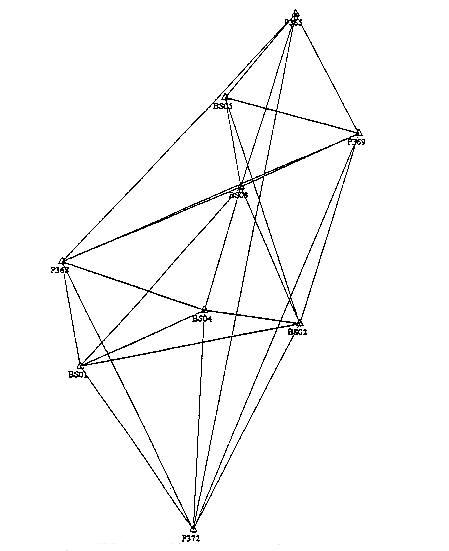
The densification of existing Peninsular Malaysia GPS Geodetic Control Network (DSMM, 1994) was effected through the establishment of 30 GPS control points at 5 km apart throughout the district. This GPS observations were carried out to provide a sufficient number of control points within the study area. As can be seen from Figure 1, this study area is bounded by GPS stations P365, P369, P372,and P368. An additional of five(5) GPS points (BS02, BS04, BS01 BS05 and BS03) were also established within the 5km block of the study area (Figure 1). All the GPS observations and data processing were completed in November 1995. The average relative accuracy of the established network is 1:250,000.
The GPS control points were connected to
cadastral boundary marks using Total Station traversing with
survey procedures adhering to the standards and specifications of
the Cadastral Standard Traverse survey. The traverse surveys to
connect the GPS points and boundary marks were completed in
December 1995.
Figure 1: GPS Control Network Densification in the Study Area
3.2 Cadastral Network
The 5km x 5km block of study area is consisted of eight(8) standard sheets where these sheets are identified as A,B,C,D,E,F,G and H. In addition, stations number given to boundary marks of a cadastral lot follow an alphabetical ordering which always starts with either A to H. As an example, let say a boundary mark 101 is in standard sheet C, therefore, following the convention above the boundary mark will be named as C101. A total of 3212 boundary marks are found in these study area (see Figure 2)
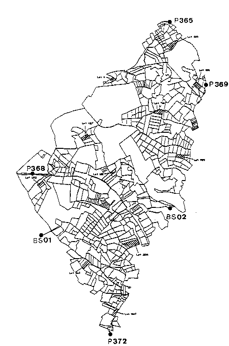
Figure 2: The 5x 5 km Cadastral Network
3.3 Network Adjustment
The workflow of data for the formation of cadastral network and adjustment is shown in Figure 3.
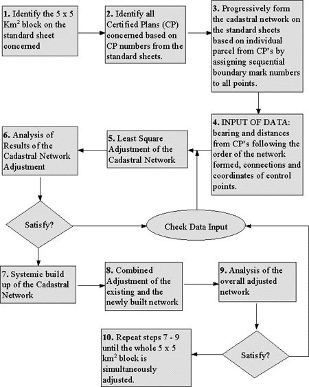
Figure 3: Workflow for the Formation and Adjustment of Cadastral Network.
The network was built up progressively from sub-block 1 to sub-block 2, sub-block 3 and so on (see Figure 4). Adjustment of a new sub-block is performed only after the successful adjustment of the preceding sub-blocks. Any data suspected to contain errors are removed during analysis and the adjustment is repeated.
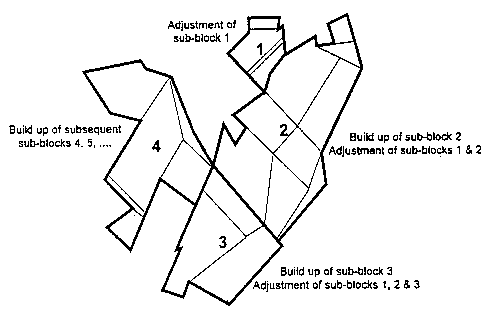
Figure 4: Creation and Adjustment of Sub-blocks
3.4 The Adjustment Software
In order to adjust the cadastral networks, the StarNetTM software which employs a rigorous least square adjustment technique was chosen for this study. The software has the capability of adjusting a two-dimensional (2D) network and a three-dimensional (3D) network as well as a combination of both type of networks. The input to the software can be bearings and distances (as in the case of this study) and other form of input. While the output is in the form of adjusted observations, coordinates and information for statistical analysis. The software is also capable to produce a graphic display of the adjusted network together with the respective error ellipses. This data can be exported to other software such as AutoCad . Special features of the StarNetTM software includes:-
The StarNetTM software may be divided into seven(7) processing components as shown in Figure 5.
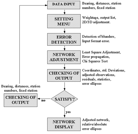
Figure 5: The Processing Components of
StarNetTM
4.0 ANALYSIS OF RESULTS
4.1 Adjustment with GPS Control Points (Adjustment I)
This initial adjustment was performed after the completion of data entry and the formation of cadastral network for the study area. Four GPS control points (P365, P368, P369, and P372) were included to constrain the network (Figure 2). As many as 7936 bearings and distances were used as observation data with 6416 coordinates parameter(N,E), thereby giving the adjustment a 1520 degree of freedom. Weightage to the observation are given inversely proportional to the accuracy of the data; 10" and 30" for first and second class bearings respectively and 0.001m for both first and second class distances. This weightage was applied throughout the whole network.
The adjustment of this fully constrained network was terminated after the fifth iteration with changes of coordinate values being less than 0.00005m and converging. Although the adjustment results indicate that the Chi Square test failed at 95% confidence level, the results were accepted since the estimated error factor of 4.12 is quite close to unity (the apriori error factor is set to unity). Table 1 provides a summary of the results of Adjustment I.
Table 1
Summary of Results of Adjustment I
| Max. Error Propagation | N = 0.157m | E = 0.137m |
| Max. Residual | Dist. = 0.012m | Az = 7' 38.73" |
| Max. Error Ellipse | S. major = 0.385m | S. minor = 0.252m |
The analysis:
A set of 83 adjusted coordinates are compared with their corresponding Certified Plan(CP) coordinates. The comparison between the two set of coordinates are shown in Table 2.
Table 2
Differences Between Cadastral Coordinates
(Adjustment I minus CP Coordinates)
Max. Diff. (m) |
Min. Diff. (m) |
Average Diff. (m) |
Range (m) |
|
| Northing | 1.738 |
0.196 |
1.258 |
1.542 |
| Easting | 1.029 |
0.261 |
0.784 |
1.768 |
The analysis:
4.2 Adjustment with Existing Coordinates as Control Points
(Adjustment II)
There are four(4) existing cadastral marks that are very close to the four GPS control points used as fixed stations as described in Adjustment I.These marks are chosen as control points for the network in Adjustment II. As many as 7914 bearing and distances were used as observation data with 6400 coordinates parameter(N,E), thereby giving the adjustment a 1514 degree of freedom.
The adjustment was iterated and the process was terminated after the fifth iteration. Again, similar to Adjustment I the results were accepted due to the closeness of the estimated error factor to unity. From Adjustment II, a set of 79 adjusted coordinates are compared with their corresponding Certified Plan (CP) coordinates. The results of this comparison is shown in Table 3.
Table 3
Differences Between Cadastral Coordinates
(Adjustment II minus CP Coordinates)
Max. Diff. (m) |
Min. Diff. (m) |
Average Diff. (m) |
Range (m) |
|
| Northing | 0.959 |
0.000 |
0.189 |
0.959 |
| Easting | 0.626 |
0.005 |
0.174 |
0.621 |
The analysis:
a) Assuming the control points are to be correct, the results indicate that there are some significant differences between the existing and the least squares adjusted coordinates.
4.3 Adjustment with More GPS Control Points (Adjustment III)
An additional of five more GPS points (BS01,BS02,BS03,BS04 and BS05) were added as control points in Ajustment III together with the four GPS control points used in Adjustment I. The increase in number as far as the GPS control stations is concern will provide a better error propagation control to the adjustment of the cadastral network. In Adjustment III, there are 7996 bearings and distances as observation data along with 6470 coordinates parameter (N,E), therefore, these gave a 1526 degree of freedom. The results of Adjustment III is summerised in Table 4. For ease of comparison, a summary of results for Adjustment I is given in Table 5.
Table 4
Summary of results for Adjustment III
(9 GPS Control Points Held Fixed)
Maximum |
Minimum |
Average |
|
Std. Dev. in Northing |
0.158m |
0.000m |
0.049m |
| Std. Dev. in Easting | 0.185m |
0.000m |
0.047m |
| Residual in Azimuth | 7' 38.73" |
0.00" |
42.87" |
| Residual in Distance | 0.012m |
0.000m |
0.001m |
Table 5
Summary of Result For Adjustment I
(4 GPS Control Points Held Fixed)
Maximum |
Minimum |
Average |
|
| Std. Dev. in Northing | 0.157m |
0.000m |
0.059m |
| Std. Dev. in Easting | 0.186m |
0.000m |
0.059m |
| Residual in Azimuth | 7' 38.73" |
0.00" |
41.61" |
| Residual in Distance | 0.012m |
0.000m |
0.001m |
The comparison between the adjusted coordinates obtained from Adjustment I and Adjustment III are shown in Table 6 while the comparison of adjusted coordinates with that of CP coordinates(for Adjustment III) are shown in Table 7.
Table 6
Differences Between Adjusted Coordinates
(Adjustment III minus Adjustment I)
Max. Diff. (m) |
Min. Diff. (m) |
Average Diff. (m) |
Range (m) |
|
| Northing | 0.259 |
0.000 |
0.077 |
0.259 |
| Easting | 0.309 |
0.000 |
0.137 |
0.309 |
Table 7
Differences Betwen Cadastral Coordinates
(Adjustment III minus CP Coordinates)
Max. Diff. (m) |
Min. Diff. (m) |
Average Diff. (m) |
Range (m) |
|
| Northing | 1.629 |
0.183 |
1.179 |
1.446 |
| Easting | 1.491 |
0.057 |
0.648 |
1.434 |
The analysis:
4.4 Adjustment of Upper and Lower Blocks (Adjustment IV)
The 5 x 5km2 block was split into two portion along the control point P368 and BS02 (refer to Figure 2). Separate adjustment were carried out for both portions. The upper portion of the block is called the upper block while the lower portion of the same block is called the lower block. The purpose of this test is to determine the consistency of least squares adjustment technique for the determination of coordinates of cadastral stations located along the common boundary between the upper and lower blocks. This is accomplished by making a comparison between adjusted coordinates of points along the common boundary that resulted from the separate adjustments of the upper and lower blocks, respectively. This will indicate the expected adjustment results between adjoining blocks.
Four GPS control points were used for each block: (1) the lower block used GPS control points P372, P368, BS01 and BS02, and (2) the upper block used the P368, P365, P369 and BS02. For the adjustment of the upper block a total of 1858 points were used with 4548 observations and 3708 parameters. This gives a 840 degree of freedom. On the other hand, in the adjustment of the lower block, 2002 points were used with 4888 observation and 3996 parameter, where these gave a 892 degree of freedom.
To determine the consistency of the adjustment results, a comparison of coordinates of points along the boundary line separating the upper and lower block were made. A total of 134 sets of coordinates were compared and the results are summerised in Table 8.
Table 8
Differences of Adjusted Coordinates
(Upper Block minus Lower Block)
Max. Diff. (m) |
Min. Diff. (m) |
Average Diff. (m) |
Range (m) |
|
| Northing | 0.128 |
0.001 |
0.083 |
0.127 |
| Easting | 0.103 |
0.000 |
0.035 |
0.103 |
The analysis:
4.5 Adjustment of an Internal Block (Adjustment V)
A small internal block was extracted from the cadastral network. This block were connected by six points used in Adjustment I (B302, C612, C594, C638, G2 and G69) (Figure 6). The control points were similar with that of Adjustment I. The purpose for this test is to simulate a future survey after the completeion of the adjustment of the existing network. A summary of the adjustment results are given in Table 9. Table 10 provides the summary of a comparison made between the adjusted coordinates of 110 internal points and their respective adjusted coordinates from the results of Adjustment I.
Table 9
Summary of Adjustment V
| Max. Error Propagation | N = 0.071m | E = 0.066m |
| Max. Residual | Dist. = 0.007m | Az. = 3' 57" |
| Max. Error Ellipse | S. major = 0.209 | S. minor = 0.117 |
Table 10
Differences of Adjusted Coordinates
(Adjustment V minus Adjustment I)
Max. Diff. (m) |
Min. Diff. (m) |
Average Diff. (m) |
Range (m) |
|
| Northing | 0.020 |
0.000 |
0.001 |
0.020 |
| Easting | 0.069 |
0.000 |
0.002 |
0.069 |
The analysis:
A comparison was also carried out on the standard deviation of the adjusted coordinates of the 110 internal points with that from Adjustment 1. The summary of the results is given in Table 11 and Table 12.
Table 11
Standard Deviations of 110 Adjusted Coordinates (Adjustment V)
| Std. Dev | Maximum (m) |
Minimum (m) |
Average (m) |
Range (m) |
| Northing | 0.097 |
0.005 |
0.055 |
0.092 |
| Easting | 0.091 |
0.007 |
0.057 |
0.084 |
Table 12
Standard Deviation of 110 Adjusted Coordinated (Adjustment I)
| Std. Dev. | Maximum (m) |
Minimum (m) |
Average (m) |
Range (m) |
| Northing | 0.083 |
0.027 |
0.066 |
0.056 |
| Easting | 0.074 |
0.051 |
0.054 |
0.023 |
The analysis:
a) There is no significant difference between the standard deviations of the adjusted coordinates of the internal points as compared with that from Adjustment I. This shows that the accuracy of the adjustment of the internal block is as good as that of the main block,
b) The results also shows that the accuracy of the internal block is within the accuracy of the main block and that the survey of the internal block is of a high degree of accuracy.
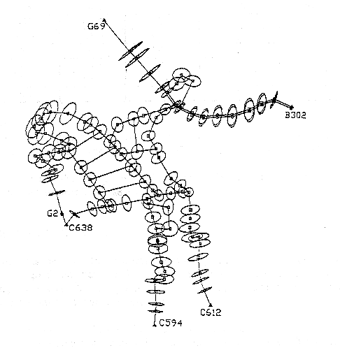
Figure 6: The Selected 2.5 km x 2.5 km Internal Network:
Error Ellipses indicate the Error Propagation Pattern
4.6 Comparison of Area
In this study, 11 lots of sizes between 1 to 5 hectares that are well distributed across the network was chosen (see Figure 2). Their areas were computed using the adjusted coordinates of Adjustment I and subsequently compared with their corresponding CP areas. The results of the comparison are shown in Table 13.
Table 13
Lot No. |
CP Area (Hectare) |
Comp. Area (Hectare) |
Difference (meter2) |
Difference (%) |
689 |
2.370 |
2.369 |
10 |
0.04 |
806 |
3.915 |
3.916 |
10 |
0.03 |
780 |
2.026 |
2.027 |
10 |
0.05 |
6 |
1.021 |
1.022 |
10 |
0.10 |
828 |
2.026 |
2.025 |
10 |
0.05 |
182 |
1.117 |
1.117 |
0 |
0 |
1256 |
4.735 |
4.733 |
20 |
0.04 |
1567 |
1.610 |
1.610 |
0 |
0 |
1217 |
2.026 |
2.026 |
0 |
0 |
1513 |
1.775 |
1.775 |
0 |
0 |
663 |
2.180 |
2.180 |
0 |
0 |
The analysis:
5.0 SUMMARY OF ANALYSIS
6.0 CONCLUSIONS
At this stage of study, the results indicates the vast potential of Coordinated Cadastral System and the study team is optimistic that the system will be feasible for Malaysia. This optimism stamped from the successful implementation of the system in other countries in the region (Australia and Singapore). The results of the study also collaborate well with this optimism. However, it must be noted that this positive results was due mainly to the high degree of accuracy and consistency of the existing surveys which in turn was due to the rigid requirements of cadastral survey by DSMM. Has this not been so, a resurvey of all existing lots would be required which is almost impossible to implement and would thus render the system impractical.
The concept of Coordinated Cadastral System may be simple, however, its full implementation would necessitates extensive administrative and procedural changes. A detail study is required of the surveying procedures to be adopted by both the public and private sectors, before the system could be fully implemented. In tandem with this, the relevant legislations will need to be revised to encompass these procedural changes. By and large, the implementation of Coordinated Cadastral System would place DSMM in a propitious position to harness the relevant technological advancement of the new millennium.
Further works are required to address the following problems:
An in-depth comprehensive study of the implications of changing the existing geodetic datum and the Cassini projection system is mandatory before any action can be taken to replace them. It is envisaged that the above study will be completed by the end of 1997 and this will be followed by a statewide pilot project in Melaka. The success of the statewide pilot project would be a needed impetus for the implementation of a nationwide Coordinated Cadastral System.
ACKNOWLEDGEMENTS
This study has been made possible through the initiative, support, cooperation and forbearance of the Director General of Survey and Mapping, Malaysia. We also would like to thank the Director of Geodesy and the Director of Survey of Melaka of DSMM for the cooperations rendered. We appreciate the kindness of the Dean of the Faculty of Geoinformation Science and Engineering, the Universiti Teknologi Malaysia for making available the computing facilities and other resources that vital for the successful implementation of this study.
REFERENCES
Abdul Majid Mohamad(1995): Keynote Address on Cadastral Surveying, the 5th. South East Asian and 36th. Australian Surveyors Congress, 16-20 July, Singapore.
Dale, Peter F. (1992): Cadastral Reform '92 - Let the user speak, Proceedings of the International Conference on Cadastral Reform '92, Melbourne, Australia, 29th. June - 1st. July, pp. 1-6.
DSMM (1994): GPS Stations in Peninsular Malaysia, Geodesy Section, Department of Survey and Mapping Malaysia, Kuala Lumpur
Houghton, H.J. (1992): Cadastral Reform: A status report for Western Australia, Proceedings of the International Conference on Cadastral Reform '92, Melbourne, Australia, 29th. June - 1st. July, pp.125-133.
Hopfer, A.(1992): Cadastral Reform-The Move From a Planned Economy to a Market Driven Approach: The Polish Case, Proceedings of the International Conference on Cadastral Reform '92, Melbourne, Australia, 29th. June - 1st. July, pp.142-151.
Majid Kadir et. al.(1996): Report on the Feasibility of Coordinated Cadastral System for Malaysia, Department of Survey and Mapping, Malaysia.
Menzies, T(1992): Cadastral Reform in the Northern Territory, Proceedings of the International Conference on Cadastral Reform '92, Melbourne, Australia, 29th. June - 1st. July, pp.116-125.
Rizos, C. (1996): Principles and Practice of GPS Surveying, GMAT5222 Course Notes, School of Geomatic Engineering, The University of New South Wales, Australia.
Tan Say Kee(1997): The Adjustment of Large Scale Cadastral Network To Support Cadastral Coordinated System, M.Sc(Surveying) Thesis, Faculty of Geoinformation Science & Engineering, Universiti Teknologi Malaysia.
Uotila, U. A. (1986): Notes on Adjustment Computations, Lecture Notes, Department of Surveying and Geodetic Science, The Ohio State University, Columbus, USA.
Williamson, I. (1991): Cadastral Reform - A Vision for The 1990s, Proceeding of the 4th. South East Asian Survey Congress, Kuala Lumpur, Malaysia, June 3-7, pp19-1 to 19-12.
Williamson, I.(1992): Cadastral Reform and the Politics of Land and Geographic Information System:-Keynote Address, Proceedings of the International Conference on Cadastral Reform '92, Melbourne, Australia, 29th. June - 1st. July, pp.7-23.