Article of the Month -
September 2005
|
New Danish Regional Development Plans – An Effort of
Combining Economy and Spatial Aspects for Urban and Rural Areas
Mette Fosgaard KRAGH, Denmark

 This article in .pdf-format
1) This article was
for the first time presented at the FIG/GSDI Conference in Cairo, Egypt,
16-21 April 2005.
Key words: spatial planning, regional development, the roles of
cities and territorial cohesion.
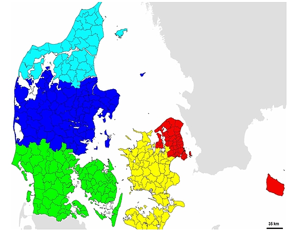
Figure 1: After the structural reform in Denmark the 12 regions will
be reduced to 5 which mainly will have the responsibility for hospitals –
but also will make regional development plans on an overall level.
1. THE PROPOSED REFORM IN DENMARK
The structural reform in Denmark creates new and very large changes in
the public sector. The reform gives more power to the municipalities, and it
gives less to the regions and more to the national level. The existing
“amter” (regions) will be deleted and 5 new regions will be created. The
existing number of municipalities will be reduced to the around 105
municipalities based on voluntary suggestions from the municipalities.
This process can be seen as an symptom of the fact, that the
municipalities are aware that to keep up in the competition, and their own
development, they must “be bigger” and more powerful.
As it is written in the agreement about the regional development plans,
the regions will be given the “task to develop a hole new and strategic toll
that covers general and overall aspects of relevance to the development of
the region.” (Agreement p. 77)
The new regions will be responsible for hospitals and will not have the
responsibility for nature and protection of land as they have had before.
Before the regions (amter) made “region planer” which was more area based
regulation of land, and the responsibility of this part of the planning
process is now, with the new reform, being giving to the larger and more
powerful municipalities. This paper will focus only of the new task being
giving to the new regions in spatial planning.
1.1 The regional development plans
The new regions shall make “regional development plans” based on visions
and strategies, based on business considerations, and the integration of
rural and urban development will be a key factor in the perspective.
The regions shall develop this new type of planning instrument in the
Danish planning system, which will be a focal point in the new regions and
their role as dynamos for regional development. The new strategic plan will
cover general and overall aspects of relevance to the regions
development, and it will be a base or inspiration and being a new umbrella
for “development initiatives” in the region.
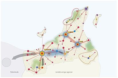
Figure 2: Just to give an idea of the intentions.
The regional development plan must have vision with a clear territorial
focus showing overall planning directions.
It is central that the regional development plans must show a complete
vision for the development in the region on a number of areas such as
nature, environment, tourism, employment, education, culture. Also the
development in the peripheral areas and rural areas must be taken into
account in the region.
It is required that the regional development plans have a figure - or map
- showing a “future picture” of the development in the region. The map will
not have legally binding commitments, but it will be an illustration of the
wished future development in the region, that the municipalities shall
follow in their own planning.
How detailed the signatures in the map will be can not the given before
hand, but the signature will bee close connected to the content of the
development plan. The signature shall illustrate, where the regional council
foresees a future development, which is suggested developed. The signatures
can show urban development, and as part of this housing and business
development, different recreation uses and infrastructure etc. The signature
is overall and broad and shows not a precise area or land.
The main function of the maps is to show, where the development plan
point on a wished development, but the regional council can not make
objections to the plans in the municipalities with the maps as the only
argument. If the map for instance show a “focus area” for future development
of knowledge based businesses in one particularly part of the region, this
does not mean that the regional development plan decides, where this type of
business can be located or can not be located. It only shows that the
regional council, after a dialog with the municipalities, the businesses and
the knowledge institutions, have found that there is a certain base for the
development of good framework conditions for that type of businesses in that
areas.
Therefore what is central when combining planning for urban and rural
development is to have a vision for the development in the whole region. The
vision must be drawn as a “future picture”, so that everyone can see, what
is agreed on as a common role for the region.
1.2 Regional business development strategies
There also is a so-called development perspective in the new plans being
presented in the parliament, which has the intention to integrate the
funding and other kinds of implementation into the plans.
The regional development plan will be based on regional business
development strategies, which are made by new so-called “Vækstfora”, being a
regional business agencies consisting of representatives from the region,
the municipalities, the local businesses, the knowledge institutions and the
labour organisations. There will be one or more if these in each region.
The regional business development strategies will take their starting
point in the main growth opportunities in the regions and the strengths and
weaknesses in the regional business structure. In the agency the initiatives
for future improvement of local growth opportunities is being developed and
prioritised, and as part of this, also the development of the rural and more
peripheral areas. The regional business agencies will also recommend to the
state how to spend the use of EU structural funds. This possibility to
integrate the structural funds also gives a other way to look at the rural
areas, by incorporating the role of cities as a driving force in the
regional development. This could give a larger focus on integrated urban and
rural development, where for division of roles between cities and rural
areas is put into focus.
2. TERRITORIAL COHESION AN EUROPEAN PERSPECTIVE
The moves made in Denmark goes towards more strategic planning, but it is
also important to recognise that for many years, this have been a
development, which has taken place also on EU level. The European ministers
responsible for spatial planning meet in Rotterdam in November last year to
informally discuss “territorial cohesion” and the new steps in their
co-operation on spatial planing, which all in all show tendencies toward a
more strategic planning. This angle will also be drawn into this paper.
2.1 European Spatial Development Perspective
The informal cooperation between the EU ministers started in 1993, where
it was decided to make an European spatial development perspective (European
Spatial Development Perspective (ESDP)).
The ESDP gave for the first time a ”strategic frame ” for a balanced and
sustainable development in the EU and it gave three principles for the
territorial development. First of all there should be a “polycentric
development”, which meant a more decentralised growth and a development of
the European territorial in other parts of areas than the main growth area
around the cities in the central part of Europe.

Figure 3: Regional development focusing on a
polycentric development, with different urban centres functioning as motors
in the regional development (polycentric development), ESDP 1999
Secondly the ESDP asked for a greater amount of equality in the access to
infrastructure, with a focus on local and regional accessibility to national
and transnational infrastructure network. And as a third part the ESDP
focuses on a reasonable administration of nature and cultural heritage,
where these are monitored after common guidelines and at the same time
viewed as regional development potentials.
Since the countries in 1999 agreed on the ESDP the political context has
changes dramatically. An important challenge is the proposed new EU treaty,
where territorial cohesion as a goal on the same line as economic and social
cohesion. The suggestion must be seen in close connection with the EU
enlargement, meaning tremendous changes in the spatial and economic balance
in the EU and in the balances in relation to the existing centre and
periphery structure. These challenges makes it difficult to deal with the
ambitions from the Lisbon strategy, about the EU being the worlds most
dynamic and competitiveness knowledge based economy in year 2010. Therefore
the Dutch presidency took the initiative to discuss the ESDP, and to analyse
the territorial structure.
2.2 The Rotterdam conclusions
The conclusions from Rotterdam can be argued to represent what could be
seen as steps in the direction of a more strategic planning, as also seen in
Denmark – aiming at integrating rural and urban development.
The overall theme that was discussed in Rotterdam was “territorial
cohesion”, and the message was that territorial imbalances and differences
must be taking into account, on the same line as socio- and economic aspects
as suggested in the EU Treaty.
The ministers agreed that development strategic must respect subsidiarity
but also have the important territorial and cultural characteristics,
identities and potentials in the regions as a focus point. Especially the
dynamic that lays in the cities development must the supported as a central
driving force in the regional development
The most important conclusion in the meeting was that regions and member
states must be aware of their development potentials and positions in
Europe. This is necessary to meet the challenges on for instance a
population that is getting older, about regional socio- and economical
differences, certain problems in urban and rural areas, the increasing
transport problem, the pressure on nature and cultural heritage etc.
Luxembourg already has - by the way - said that the next informal
ministers meeting will be June 2005. Here the ministers will discuss a short
synthesis report, which will give a view of the ”territorial conditions of
the union, and will be a common basis of inspiration for the future European
work.
3. THE REGIONAL DEVELOPMENT PLAN - A POSSIBILITY TO FOLLOW UP ON
ROTTERDAM
The thoughts from Rotterdam is not unknown in Denmark, where we, through
the work in the EU sub committee on ”Spatial and urban development”, been
active in the preparation of the ministers meeting.
Also the most resent documents on national spatial planning policy in
Denmark (“landsplanredegørelser”) have focused on the need and necessity of
an integrated urban and regional development, building on the regions unique
potentials and strengths.
In Denmark there are already different regional corporations that today
have reached territorial cohesion. There have been made different regional
strategies in co-operation between municipalities that discuss the
interrelation ship between cities and the surrounding rural areas. As well
as the regions overall role on a national and international level. This is
also being developed in so called ”dialogprojekter” – follow up projects on
the national spatial planning report. In these for instance the
municipalities in NorthWest Sealand and North Jutland discusses their
regional roles and possibilities in relation to the larger surrounding
world.
If the proposed regional development plan will be adopted in Parliament
in the form that is known today, there lays good possibilities for the
regional development plans to play further with the new European “planning
tunes”.
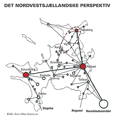
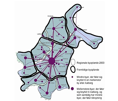
Figure 5: In Denmark different co-operation
between municipalities or unique characteristics in regions gives a starting
point in discussing a common strategy. The maps show regional relations in
NorthWest Sealand and North Jutland (below) [Dialogprojekt 2004: Bymønster
og bykvalitet], [Nordjyllands Amts Regionplan 2004]
The regional development plans shall as mentioned in the beginning draw
together the regional development strategies with education, employment,
culture, nature and environment. This will give the possibility to use the
regional development plan to co-ordinate the sectors with each other, with
their plans geographically and regionally. The discussion about what should
be the strategic focus in each region almost can not be taken with out also
having a discussion on where the development should take place. In other
words: “the future geographical profile” in different parts of the region,
its cities, rural areas and peripheral areas.
The regional development plan will not include a detailed regulation of
land use. This is for the future taken care of in the municipality plan. It
is there for too early to say, how detailed a geography and how much sector
co-ordination the regional development plans will contain.
3.1 National spatial planning level
On a national level it would be natural, that we in Denmark follow up on
the recommendations from Rotterdam and creates clearer physical and
functional strategies for whole Denmark, seen in a European and global
setting. In the national spatial planning reports it has been underlined
that each municipality and region organises it self in relation to the
regional development.
The national spatial planning policy has shown that there are different
territorial connections in the country, which gives different territorial
patterns and dynamisms. But a real territorial national strategy has not
been the case.
The message from the European minister is that the national policy also
should contain some kind of spatial strategies. The thoughts on what one
would like to do should not be thought without connection to an imagination
about where one would like to do this. There should be some kind of a
geographical profile in the national policies, which will be new for some of
them.
The meeting in Rotterdam was informal and could not take binding
discussions. The Danish government is not obliged to follow the political
directions. But the effort should on the other hand be tried, and the
national planning policy document, which will be made in 2005, would be a
natural place to start. The future regional development plans will be a
central element of the regional input to the future national planning
policy.
The government will in its national planing policy put forward a vision
for the country development and an overall decision on the development that
will take place in different parts of the country. The national analysis and
co-ordinated physical and functional problem areas can give a possibility to
see the development in one region in close connection to what the sate it
self wants to do. Depending on what the government want to do, the national
planning document give the possibility for each region to see itself into a
larger connection.
4. CONCLUSION
The Danish case has shown new attempts for integrating spatial planning
in urban and rural areas. It has also shown efforts in developing a more
strategic planning where business and development perspectives plays a
central role.
What is important - is to have a common vision among the municipalities
about the development of the whole region, and what this will mean for the
development in different parts of the region. And also what is important is
to have a possible combination with the economic funding, which gives the
possibility to implement the plan.
The move made in Denmark goes towards more a strategic planning, and this
have been development, that has taken place also on EU level. The European
ministers responsible for spatial planning meet in Rotterdam in November
last year to informally discuss “territorial cohesion” and the new steps in
their co-operation on spatial planning. This show also tendencies toward a
more strategic planning.
The conclusions from Rotterdam can be argued to represent an aiming of
integrating rural and urban development.
The overall message that was discussed in Rotterdam was that territorial
imbalances and differences must be taking into account, on the same line as
socio- and economic aspects.
Territorial cohesion is not new in Denmark. On the regional level there
have been made different regional strategies in co-operation between
municipalities that discuss the interrelation ship between cities and the
surrounding rural areas, as well as the regions overall role on a national
and international level. This is also being developed in so-called
”dialogprojekter” – which is following up projects on the national spatial
planning report.
The new regional development plans shall now as mentioned in the
beginning draw together the regional development strategies with education,
employment, culture, nature and environment. This will give the possibility
to use the regional development plan to co-ordinate the sectors with each
other, with their plans geographically and in a regionally perspective. The
discussion about what should be the strategic focus in each region almost
can not be taken with out also having a discussion on where the development
should take place. In other words: “the future geographical profile” in
different parts of the region, its cities, rural areas and peripheral areas.
On a national level the national spatial planning reports has underlined
that each municipality and region organises it self in relation to the
regional development. The national spatial planning policy has shown that
there are different territorial connections in the country, which gives
different territorial patterns and dynamisms. But a real territorial
national strategy has not been the case.
The government will - in its national planing policy - put forward a
vision for the country development and an overall decision on the
development that will take place in different parts of the country.
Depending on what the government wants to do, the national planning document
could give the possibility for each region, and the regional development
plan, to see itself into a larger connection.
Therefor much is still to be observed. Never the less a shift in how to
make good spatial planning has come to Denmark, introducing strategic
elements on regional and municipality level. In a time where different
sectors – transport, environment, nature ect. - increasingly uses planning
methods in their own sector planning, the good old spatial planning has
moved towards being much more integrated with business consideration and
using scenarios in the development planning for the future.
REFERENCES
- The agreement between the gouvernment and dansk folkeparty, June 2004
- Miljøministeriet, “Landsplanredegørelse 2003. Et Danmark i balance –
hvad skal der gøres ?”
- Nordjyllands Amt, 2004, “Fremtidens Nordjylland – et debatoplæg til
den nye regionplan”, NordVest Sjælland samarbejdet, “Dialogprojekt 2004:
Bykvalitet og Byroller”,
- Europe Commission, European Spatial Development Perspective (ESDP),
Potsdam, May 1999
BIOGRAPHICAL NOTES
Mette Kragh is employed in the Danish Spatial Planning Department,
tasks related to EU structural funds, Nordic regional policy and the Danish
national spatial planning policy. She has also been employed in two Danish
regions dealing with land use planning, management and administration.
Member of the FIG Commission 8, Danish delegate.
CONTACTS
Mette Kragh
Danish Ministry of the Environment
Spatial Planning Department
Danish Forest and Nature Agency
Haraldsgade 53
DK-2100 Copenhagen Ø
DENMARK
Tel. +45 39 47 20 00
Fax +45 39 27 98 99
Email: Kra@sns.dk
www.lpa.dk
 |