FIG PUBLICATION NO. 64 2nd EditionReference Frames in Practice ManualCommission 5 Working Group 5.2 Reference Frames
|
 |
|
|
 |
This publication as a .pdf file (60 pages, 3.3 MB) |
![]()
Commission 5 of the International Federation of Surveyors (FIG) helps practising surveyors in FIG member associations to apply Positioning and Measurement technologies efficiently and effectively in their day-to-day survey activities. One of the most significant technologies to positively impact positioning in recent decades is that of Global Navigation Satellite Systems (GNSS).
The broad adoption of GNSS positioning technologies introduced the need for countries to move from locally defined geodetic datums to more regional and global datums based on the International Terrestrial Reference Frame (ITRF). In 2014, Commission 5 responded to this industry need with great initiative, by curating a series of fact sheets to educate surveyors of key issues around reference frames. One decade later, the document you are now reading is the first update to this reference frames in practice manual and includes updates around GNSS constellations, positioning modes, and new international initiatives and organisations working towards sustainable reference frames.
Commission 5 endeavours to raise awareness around relevant positioning and measurement information for our members through publications, workshops, seminars and online events. Alone, this cannot be done effectively. So it should not be surprising to hear of the collaborative efforts of Commission 5 partners – both longstanding and new – who have generously provided their support over the years to amplify the effectiveness of our Commission efforts, such as this updated reference frame manual. These partner organisations include the United Nations Office for Outer Space Affairs (UNOOSA) and its International Committee on GNSS (ICG), the International Association of Geodesy (IAG), the International GNSS Service (IGS) and the newly established UN Global Geodetic Centre of Excellence (GGCE). Gratitudes are given to the evergreen group of technical experts who continue to share their time and insights in the ongoing Commission 5 Workshops on reference frame topics, held alongside FIG and partner organisation events.
In particular, I wish to acknowledge the strengthening partnerships of Commission 5 with IGS and the UN-GGCE. With a common vision around the critical need to build capability and develop capacity in all things geodesy, including reference frames, I am very grateful for the forewords provided by Allison Craddock and Nicholas Brown, and the opportunities we all have to ‘move the needle’ in a positive direction.
For the foreseeable future, and beyond, Commission 5 will continue to collaborate together with its partners to deliver relevant and fit-for-purpose information on Positioning and Measurement through publications, seminars, working groups, joint study groups and those yet to be created.
We look forward to your continued readership, participation and support in understanding, appreciating, promoting and adopting consistent, robust and sustainable reference frames for the greater good of humanity and environment – no matter what application or market.
Ryan Keenan
Chair, Commission 5 (2023–2026)
International Federation of Surveyors
![]()
People around the world use Global Navigation Satellite Systems to connect to the reference frames that describe every location on Earth with three coordinates, and accurately relate this to any other location.
The International GNSS Service (IGS) is a key contributor to the International Association of Geodesy (IAG) and its Global Geodetic Observing System (GGOS), and part of the International Union of Geodesy and Geophysics (IUGG). It seeks to enable the highest-accuracy usability of Global Navigation Satellite System (GNSS) technologies by producing high-quality, openly and readily available GNSS data and products.
The IGS operates as a voluntary federation of more than 200 worldwide agencies and institutions in over 90 countries. It combines resources and expertise to provide the highest quality Global Navigation Satellite Systems (GNSS) data, products, and services in order to support high-precision applications of GNSS. Additionally, the IGS coordinates a global network of over 500 GNSS ground stations, along with data and analysis centers to provide the data and derived data products that enable the use of GNSS technologies for scientific applications, such as the improvement and extension of the ITRF, monitoring of solid Earth deformations, monitoring of Earth rotation and variations in the liquid Earth. Applications also include satellite orbit determinations, precise timing, and monitoring of the ionosphere and troposphere.
The IGS, through its participation in regular historical data reprocessing campaigns, is also a major contributor to the realization of the International Terrestrial Reference Frame (ITRF), which is a fundamental standard that provides the scale for global measurements in science, engineering, and an ever-expanding number of applications now common in daily life. The distributed IGS products, which include the orbits of GNSS satellites, are expressed in the latest realization of the ITRF and allow any user of the GNSS systems to express its coordinates in this frame anywhere on the planet.
In 2020, we formally recognized the important link between the IGS and FIG Commission 5 through mutual representation in our governance and close collaboration on community engagement, outreach, and capacity development. This manual, along with in-person and hybrid meetings held around the world, is an important resource ensuring that the surveying and land use community has access to – and the capacity to benefit from – the openly available GNSS data that IGS provides.
Our global geodesy community forms the backbone of an ever-increasing number of everyday applications depending on GNSS-based positioning data. Surveyors are an important part of this community, as they are the ultimate translators of GNSS data to legal and reliable positioning information that touches lives all around the world.
The IGS is thankful to our colleagues and organizations around the world for their contributions to our work. We look forward to continuing our close collaboration with FIG and the surveying community, and encourage anyone curious about learning more about the IGS to visit our website at: www.igs.org
Allison B. Craddock
Director of the International GNSS Service Central Bureau
(2018–Present)
UNITED NATIONS GLOBAL GEODETIC CENTRE OF EXCELLENCE (UN-GGCE)
![]()
I remember going to geodesy classes at university. I found, and still find, the topic equal parts fascinating and daunting. The need to measure changes in the shape, orientation and gravity field of the Earth with great accuracy and then sometimes fix it to provide a stable point of reference for practical applications. This is not an easy exercise and highlights the importance of the Reference Frames in Practice manual. I trust this manual will help you embark on a journey through the practical application of reference frames. We’ll explore how to choose the most appropriate reference frame for a given scenario, how to transform between reference frames, and how to use reference frames to solve problems.
So, whether you’re charting the trajectory of a spacecraft, designing a land administration network, or simply pondering the mysteries of the cosmos, let this manual be your companion in the fascinating world of reference frames.
Happy exploring!
Nicholas Brown
Head of Office
United Nations Global Geodetic Centre of Excellence (UN-GGCE)
Editors:
Ryan Keenan and
Graeme Blick
Authors: Graeme Blick (New Zealand), Nicholas Brown (Germany), Allison
Craddock (United States), Nic Donnelly (New Zealand), Roger Fraser (Australia),
Matt Higgins (Australia), Ryan Keenan (Australia), David Martin (France), Luibov
Poshyvoila-Strube (Germany), Paul Rebischung (France), Chris Rizos (Australia),
Daniel R. Roman (United States), Ryan Ruddick (Australia), Rob Sarib
(Australia), Tomas Soler (United States), Richard Stanaway (Papua New Guinea),
Neil D. Weston (United States).
Read the full FIG Publication 64 2nd edition in pdf (English)
(This publication is available only in pdf)
Copyright © The International Federation of Surveyors
(FIG) 2024., May2024
All rights reserved
International Federation of Surveyors (FIG)
Kalvebod Brygge 31–33
DK-1780 Copenhagen V
DENMARK
Tel. + 45 38 86 10 81
E-mail: FIG@FIG.net
www.fig.net
Published in English
Copenhagen, Denmark
ISSN 2311-8423 (pdf)
ISBN 978-87-93914-14-8 (pdf)
Published by
International Federation of Surveyors (FIG)
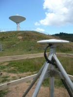
Front cover photo: © Land Information New Zealand;
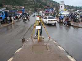
back cover photo: © Henry Murwa, Digmap Consultants, Kenya
Design: International Federation of Surveyors, FIG and Lagarto
Reference Frames in Practice Manual
Commission 5 Working Group 5.2 Reference Frames
Published in English
Published by The International Federation of Surveyors (FIG), May 2024
Copenhagen, Denmark
ISSN 2311-8423 (pdf)
ISBN 978-87-93914-14-8 (pdf)