Historical Surveying Instruments from Bohemian Region
by Pavel Hánek and Antonín Švejda
Key words: history of surveying, production of surveying
instruments, verification of surveying instruments quality.
Abstract
1 Introduction
On the occasion of FIG Working Week Prague 2000
there will be held (within the framework of Prague 2000 European town
of culture activities) an exhibition of "Historical Geodesy
Instruments from Bohemia" in The National Technical Museum (NTM)
from May 15 to July 15, 2000. The exhibit will focus on the two
periods associated with advanced economic and political development of
the Czech state: the reign of Emperor Rudolf II and the end of the
19th and beginning of the 20th centuries.
An important aspect of preparing for this
exhibition has been the testing of the quality of the historical
instruments using modern methods based on international standard
ČSN ISO 8322 (1996) in addition to some tests which are no
longer performed. These results have been incorporated into several
thesis studies on geodesy which were defended at the Faculty of Civil
Engineering at the Czech Technical University (CTU) in Prague.
2 History
One of the peaks of science advancement in the
Czech lands occurred during the reign of Rudolf II (1552 – 1612). In
his court, which was significant in Europe, worked the naturalist and
doctor of medicine Tadeáš Hájek z Hájku, who conducted the
first triangulation of the area surrounding Prague. Thanks to him,
Tycho Brahe and Johannes Kepler came to Prague where he designed a new
type of astronomical telescope in 1611 and defined the first two laws
on the movement of planets. In addition, several important European
craftsmen worked for the Emperor. Jost Bürgi (1552 – 1632) became
the Emperor’s watchmaker in 1604. In 1610 he compiled logarithmic
tables which J. Kepler himself relied on. Erasmus Habermel (+1606)
designed a theodolite, levelling and triangulation instruments and
artillery direction finder. He also made astronomical instruments,
sundials and armillary spheres. The mathematical instruments of Doctor
Franciscus Paduarius of Forli on exhibition also come from Habermel’s
Workshop. A particularly fine decorative piece in the exhibition is
the gilded theodolite with an azimuthal sundials and diagrams of
mathematical functions from the period 1608 – 1613. The piece was
created by Heinrich Stolle, who collaborated with J. Bürgi.
At the time, outstanding results were achieved in
practical geometry which confirms the quality of the instruments. For
example, a unique water tunnel was constructed in Prague during
Rudolph’s reign. Just before the project was completed in 1593 a
member of the court office, Isaac Phendler, made a drawing of it for
the Emperor. The scale of the plan is 1: 540, and is also presented in
exhibition.
The Thirty Years War brought economic collapse in
the Czech Lands and resulted in the emigration of many intellectuals
and a general decline in the importance of Prague. Nevertheless,
thanks to Kristian Joseph Willenberg (1676 – 1731) and a charter by
the Emperor, the Estate Engineering Institute in Prague (which was
predecessor of the Czech Technical University) began to offer two-year
instruction beginning on January 1, 1707. Lectures were given in
arithmetic, geometry, practical geometry (geodesy) and fortress
engineering.
In the 19th century, which witnessed economic
growth and the Czech national revival, the growing economic influence
of the Czech Lands resulted in new workshops devoted to the production
of measuring instruments and aids. The first workshop was founded in
1808 by Josef Božek (1782 – 1835), a watchmaker and craftsman at
the Prague Polytechnical Institute. His sons František (1809
– 1886) and Romuald (1814 – 1898) continued his work. The Spitra
workshop manufactured instruments which were comparable with similar
European products of that time. Three generations of this family (František,
Václav Michal and Otakar) worked in Prague from 1820 till the end of
the century. About 1840, another significant master, Mathias Richard
Brandeis (1818 – 1868), started to produce his own measuring
instruments. After his death, the workshop was taken over by the firm
Haase & Wilhelm. Prague became a centre of this sort of
production, and in 1890 there were 24 workshops of this kind; by the
end of century there were 40 such firms. Of those craftsmen who did
not stay in Prague we have to mention the forester Karl Gangloff (1809
– 1879).
Individual instruments were designed by many Czech
specialists. We should note the hypsometer of Karel František Edvard
knight Kořistka (1825 – 1906), professor of Prague Technical
University. Professor František Müller (1835 – 1900) designed an
instru ment for graphical levelling. Forester and land surveyor
Antonín Tichý (1843 – 1923) designed a logarithmic tachymeter.
Professor of Czech Technical University F. Müller and his successor,
professor and chancellor František Novotný (1864 – 1918), were
authors of the first modern Czech textbook of geodesy (Compendium
geodesy higher and lower, Prague (1884 – 1913).
In 1883 brothers Josef (1861 – 1945) and Jan
(1863 – 1897) Frič established in Prague the family firm which,
till the beginning of the 1950s, manu factured a full range of
geodetic instruments and aids including a two-second triangulating
theodolite 6R. In 1884 / 85 the firm made a small series of mining
theodolites under the name of DUPLEX. The divided circle used in these
instruments were made from glass for the first time in the world. The
firm of Eichler was another important manufacturer in the town of
Ústí nad Labem in the first half of the 20th century. Srb and Štys
was a firm founded in 1919 and its successful department of geodesy
was taken as a base for the national
enterprise MEOPTA Košíře after 1945. They successfully overcame
the obstacles caused by World War II and went on to attain high levels
in European production. In 1961 Czechoslovak technical experts
learned about the development of new full range of the theodolites.
Shortly after this announcement production was stopped.
The Koula factory manufactured photo reproduction
instruments and instruments for the evaluation of photographs. Between
1930 and 1935 the factory supplied semiautomatic and fully automatic
aerial chambers to the Czechoslovak Army. Hand aerial chambers were
also produced by the Prague firm HAAGER. Photogrammetry instruments
were designed and produced by Prague’s
firms A. LÖSCHNER and V. KOLÁŘ.
Ass. Prof. Pavel Hánek, PhD
Czech Technical University of Prague
Faculty of Civil Engineering
Department of Special Geodesy
Thákurova 7
16629 Praha 6
CZECH REPUBLIC
E-mail: hanek@fsv.cvut.cz
Dipl. Ing. Antonín Švejda
National Technical Museum Prague
Exact Sciences Department
Kostelní 42
17078 Praha 7
CZECH REPUBLIC
E-mail: antonin.svejda@ntm.cz
Historical Surveying Instruments from Bohemian Regioan
1. INTRODUCTION
On the occasion of the FIG Working Week Prague 2000, „Exhibition
of Historical Surveying Instruments from Bohemian Region" is taking
place in the National Technical Museum in the period of 15.5. - 15.7.2000
within the action Prague 2000 – European City of Culture.
The authors of this contribution, who are also the
authors of the exhibition topic, informed the scientific public about the
history of manufacturing of surveying instruments in the Czech lands at the
XXI. FIG Congress in Brighton (Hánek, Švejda 1993). The exhibition is
complemented with a production of photogrammetric instruments and tools. The
focus of the exhibition is – in accordance with the economic and political
development of the Czech state – the time of the rule of Emperor Rudolph
II and the turn of the 19. and 20. centuries. Besides the National Technical
Museum, an organiser of the exhibition, the exhibits were borrowed also from
collections of the Technical Museum Brno, the Technical University Ostrava
– the Faculty of Mining, the Departments of Geodesy of the Faculty of
Civil Engineering, CTU Prague, and also from the private collections.
The part of preparation was a verification of surveying
instruments quality in accordance with the international standard ČSN
ISO 8322 (1996), with a completion of parameters, which have already been
nearly forgotten. The verification was an objective of some diploma works
conducted at the Department of Special Geodesy and defended at the Faculty
of Civil Engineering, CTU Prague. The short review is listed in the
conclusion of this contribution.
2. HISTORY OF PRODUCERS
2.1. THE RUDOLPHINE AGE
One of the peaks of the science flourishing, the part of
which was also a surveying instruments production on our territory, is the
period of the reign of the art-loving Renaissance ruler Rudolph II. (1552
– 1612). In 1583, he moved his seat to Prague, which became a significant
European metropolis, attracting specialists of all fields. At the imperial
court, the notable scientist and doctor Tadeáš Hájek from Hájek, known
also as an author of the first triangulation of the Prague’s area, was
working. Due to him the renowned astronomers Tycho de Brahe and Johannes
Kepler, who also cooperated on the instruments construction, came to Prague.
Around 1610, Kepler designed his type of the so-called astronomic telescope,
which is widely used even in geodesy. Besides these scientists, some
significant European mechanics were also working at the imperial court. Many
of their masterpieces soon spread out or were lost in the Thirty Years’
War (1618-1648). All the collection from the aforesaid period comes from the
collection of the National Technical Museum (Švejda 1997).
The famous Jost Bürgi (lat. Iost Byrgi, 1552-1632),
Swiss by origin, worked on the Dukes of Hessen court, which belonged to one
of the prominent European scientific centres. Since 1602 his works had been
protected by the imperial privilege, a certain precursor of the patent
protection. In 1604, he became the Emperor’s watchmaker. An instrument for
perspective drawing, working on the basis of a theodolite, is dated with the
year 1604, too. In 1609, Jost Bürgi made for the Duke of Hessen a precise
triangulation instrument, based on the triangles similarity, which is today
a pride of the collection of the Museum in Kassel. In 1610, J. Bürgi
assembled, according to J. Kepler, who himself used them, logarithmic
tables. Even if he surpassed John Napier, he was hesitating with the
publishing for ten years, so that John Napier had published it before him.
The Bürgi’s type of ratio compasses from the 17. century is also
presented at the exhibition.
Another eminent creator was Erasmus Habermel (?-1606). He
is an author of theodolites, the levelling instrument, and the triangulation
and artillery surveying instruments, which are mostly in foreign
collections. A part of the world-renowned collection of gnomonic instruments
installed in the National Technical Museum in Prague (NTM) is the functional
and by its artistic manufacturing, perfect equatorial sundial clock with
altimeter. The exhibited collection of mathematical instruments (ratio
compasses, mason’s levels, compasses and drawing instruments), fabricated
for the Emperor’s physician Franciscus Paduanius from Forli, also comes
from Habermel’s workshop.
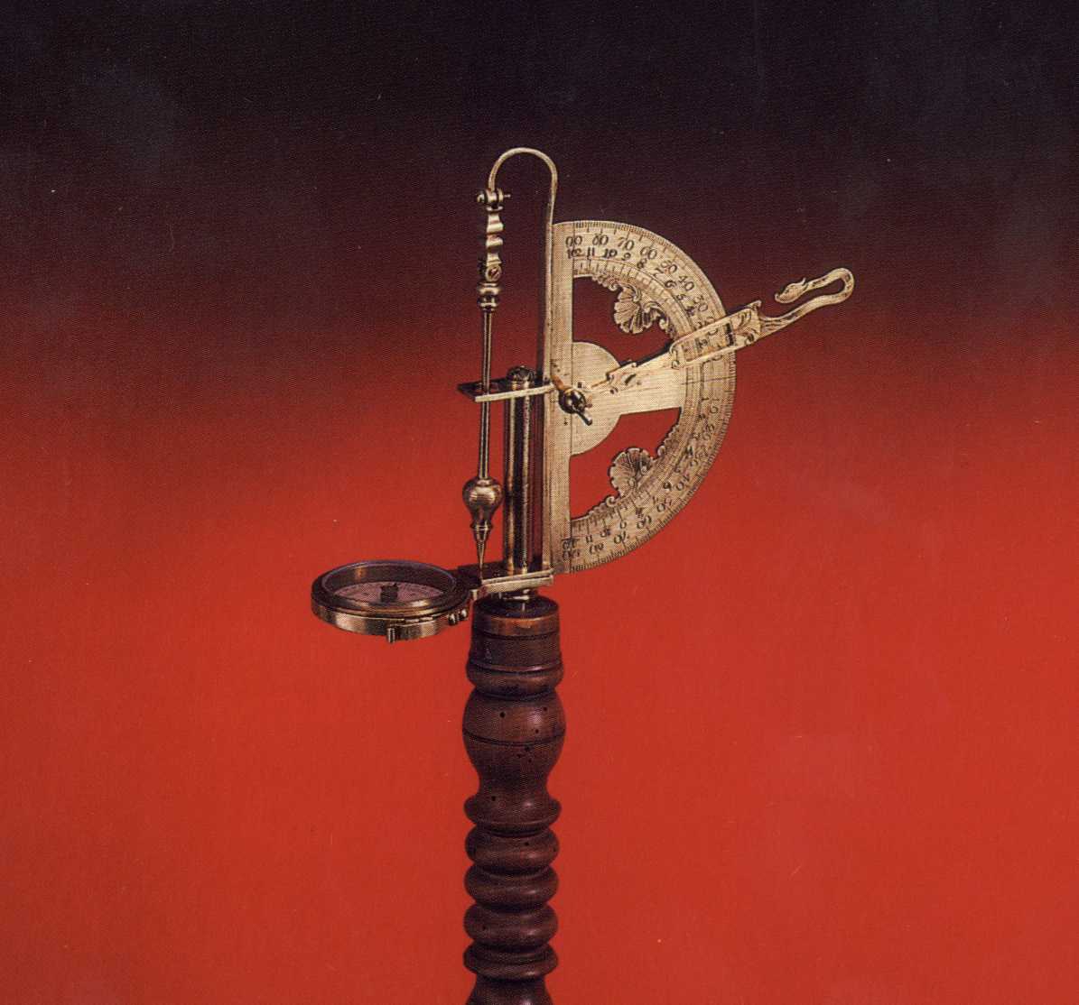
A decoration of the exhibition is the gilded brass
theodolite with the azimuthal sundial clock and an extensive set of
mathematical functions (e.g. goniometric functions, lengths of triangles
sides) coming from the years 1608-1613. The author is Heinrich Stolle, a
co-operator of aforesaid J. Bürgi.
The mentioned instruments were, for their purpose,
certainly rather exceptional. Nevertheless, the surveying practice itself
reached excellent results, which is an evidence of the high level of the
commonly used instruments. The construction of the unique water tunnel (the
so-called Rudolph’s Tunnel), finished after eleven-year-work in 1593, is
an excellent example. The straight tunnel, with a diameter of (0.7-1.5) x
(3-4) m approximately, traverses mostly natural rock, 43 m under the surface
at maximum. It is 1.1 km long with an elevation of the ends of only 1.12 m.
The tunnelling was performed from both ends simultaneously, on the route
there were 4 vertical shafts, sunk from the surface. (Note: the tunnel is
running near the building of NTM). Outstanding engineers of that age
gathered at the tunnel construction. Just before the tunnel finishing, a
clerk of the court office Issac Phendler drew for the Emperor’s
information a front view map at a scale of 1:540 (Hánek 1994). A modern
copy is presented at the exhibition.
2.2. PRODUCTION OF THE 18. CENTURY
The events of the Thirty Years’ War brought on our
territory, little by little, an economic collapse, an emigration of many
intellectuals and an overall decline into the provinciality, which also
affected fine mechanics. In the following years only small surveying,
mapping and drawing tools or unique pieces, manufactured on commission, were
produced in small workshops. This period is at the exhibition represented by
the mining instrument, the so-called schinzeug, the all-circle astrolabe, or
the telescopic drawing board (sketching pad), designed by Reitzenstein.
It is good to remind at this place that it was just an
imperial engineer Joseph Christian Willenberg (1676-1731), at whose
initiative and request from 1705, the Estates School of Engineering in
Prague was established. This institution, which was a precursor of today’s
Faculty of Civil Engineering, was founded on the basis of the Foundation
Charter, issued by Emperor Joseph I and written in Czech. Two-years teaching
included arithmetic, geometry, practical geometry, the so-called geodesy,
and military engineering. A distinguished professor of Prague’s
Engineering School, František Linhart Herget (1741-1800), was the leading
surveyor and the examiner of united estate cadastre, founded in 1785 by
Emperor Joseph II (1741-1790). He also issued certificates for the designed
surveying instruments.
2.3. DEVELOPMENT IN THE 19.CENTURY TO THE HALF OF THE
20. CENTURY
In the 19th century, connected with the industrial
revolution and the Czech National Revival, a recovery of surveying
instruments and tools arouse. It corresponded to the increasing economic
influence and development of Bohemia within the Habsburg monarchy. The first
mechanical workshop was founded in 1808 by Josef Božek (1782-1835), who had
been since 1805 a watchmaker and mechanic of the Prague Polytechnic
Institute. A successor in his function and the workshop became his son
František (1809-1886), and also his second son Romuald manufactured
instruments. They both continued in the manufacturing of individual, often
unique scientific instruments, including surveying instruments. Above the
average, in comparison with other European production, works signed by the
name Spitra excelled. Three generations of the family (František, Václav
Michal and Otakar) were working in Prague since 1820 till the end of the
century. Roughly since 1840, another outstanding master, Mathias Richard
Brandeis (-ys; 1818-1868), was manufacturing surveying instruments. After
his death, the firm Haase & Wilhelm overtook his workshop. At the
exhibition these very producers are represented by the extensive collection
of angular and levelling instruments, topographic sets diopters and a
heliotrope.
In 1890, there were in Prague, the centre of production,
twenty-four workshops producing surveying instruments, at the end of the
century there were even four dozens. As for the quality, the company Strejc
& Dušek was the best among producers of drawing sets. From the
designers and producers outside Prague, the most remarkable one was Karl
Gangloff (1809-1879), a head forester in Rožmitál under Třemšín. He
was an author of many tools and aids for the so-called forestry geodesy,
various types of dendrometers and planimeters in particular. In the first
half of the 20. century, the company Eichler, whose production is at the
exhibition represented by a universal theodolite, had its seat in Ústí
upon Labe.
Many Czech specialists designed individual instruments
– often for companies in Vienna. To name at least a few: the hypsometer
designed by a distinguished professor at the Prague’s Polytechnic, Karel
František Edvard Knight Kořistka (1825-1906), the instrument for
graphic levelling by Professor František Müller (1835-1900) or the
logarithmic tachymeter by an outstanding forester and railway surveyor Dipl.
-Ing. Antonín Tichý (1843-1923).
Professor of Prague’s Czech Polytechnic, František Müller
and his successor, the professor and rector František Novotný (1864-1918),
became authors of the first modern Czech textbook of geodesy (very quality
four-parts unfinished Compendium of Higher and Lower Geodesy, Prague
1884-1923).
2.3.1. COMPANY J. & J. FRIČ
In 1883, a turning point in the hitherto production of
surveying instrument arouse, when brothers Josef (1861-1945) and Jan
(1863-1897) Frič founded in Prague „the Shop for the Precise
Mechanics". The area of interest and a creative invention of both
brothers were very broad. Besides the designing and the production of
manufacturing instruments for an equipment of their own shops, they also
constructed a polarizer and an analyser, and also a bareoscope for the
indication of the sugar juices density. They also designed machines for the
division of circles of surveying instruments, for grinding of lenses, and
many other constructions. Their participation at the General Land Exhibition
in Prague in 1891 ended with a big success. After 1906 the enterprise J.
& J. Frič produced a polarimeter for sugar content indication,
which was accepted as the official standard in the USA.
The family led enterprise of the Frič Brothers was
during its existence producing the whole assortment of surveying, mapping
and cartographic instruments and tools, including the prestigious
triangulation theodolite 6R with the screw micrometers and reading by
estimation up to 2² , and special instruments for the measuring of the dam
deformations and the tunnel constructions. The enterprise closed down after
its nationalization at the beginning of 1950s’, when it was within the
national enterprise Metra switched to another production.
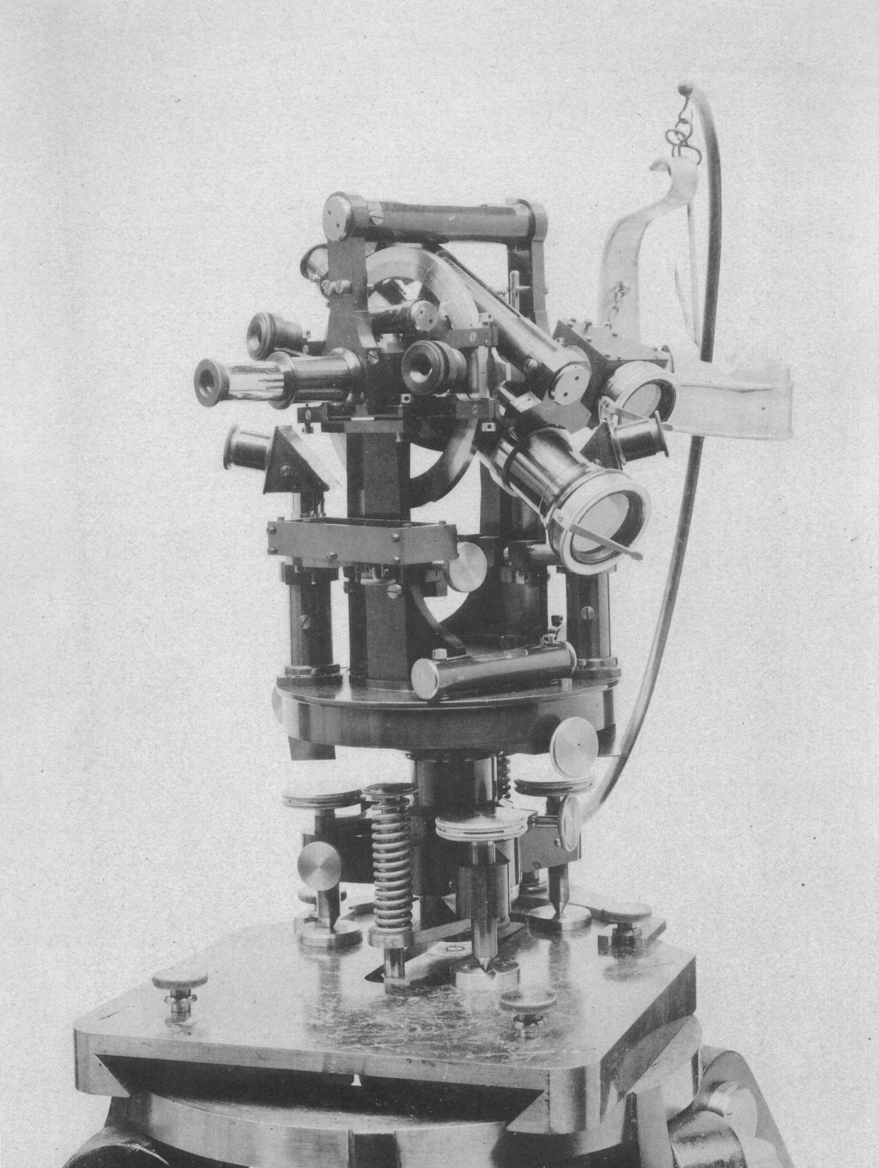
In 1884/1885, a small series of mine theodolites DUPLEX,
in which for the first time in the world a divided ring of glass was
utilized, was produced. The horizontal ring with 130 mm in diameter was made
up from the 8 mm thick mirror glass. At the upper edge it was divided with
diamond chisel by 1° , the numbering was engraved with the pantograph of
Milanese type with 25x reduction. The engraving was filled with graphite
powder. The ring was illuminated with a burner through a small window at the
bottom of the ring cover. The angle minutes were read directly, by estimate
30² , by means of two opposite microscopes with 24x magnification, with the
optical axis bent by a prism. The theodolite was universally usable for
angular measurements (astronomic connections at the surface, and
polygonization and steep measurements under the surface), but also for
levelling. The Frič Brothers posed themselves 17 conditions for the
construction of the repeating instrument with fine settings. Many of them
are commonplace today (e.g. folding tripod, fixed and flexible fastening,
nadir and zenith centering, reversible telescope with a visor illumination
of a viewing field, covering of rings and other parts, and a possibility of
the complete rectification of all mechanical axis relations). The Duplex had
a height, including the setting level, of 28 cm and the width of 21 cm,
which is roughly half of the usual sizes of that time. For easy targeting in
vertical planes, two telescopes of variable lengths were chosen. The axis of
the telescope for very steep measurements went through the concave turning
axis of the top and insertion telescope with the reverse levelling tube and
it was in the objective part (on the opposite side of the vertical metal
ring with verniers) rectangular bent. A description of the construction was
published in 1886 in the prestigious journal „Zeitschrift für
Instrumentenkunde“ (Frič J. & J. 1886).
At the exposition in Brussels in 1888, another remarkable
novelty was presented, a hanging mining measuring compass of Kassel type
with a vernier needle. Lateral oscillations of the knife needle were dumped
with a friction mica disk so effectively that it might had been at the both
ends equipped with verniers. The compass was divided into the traditional 24
hours, the smallest section of the ring had the value of 2m, a
section of the vernier 10s, i.e. 2¢ 30² in the sexagesimal ring
division into 360° .
On the basis of the brilliant idea of Prof. F. Nušl, the
construction of astronomic-geodetic circumzenithal instrument for definition
of geographic coordinates by the method of the same heights was solved out.
The advantage compared to astrolabes was, among others, a vertical division
of the picture and a placement of the mercury horizon in the centre of the
instrument. In 1932, the impersonal micrometer, according to the design of
Prof. E. Buchar, was constructed. In 1970s, the construction was further
improved by the Research Institute for Geodesy, Topography and Cartography (VÚGTK
in Czech, now located in Zdiby), which is producing the instrument under the
name 1000/100. The same staff constructed other astronomic instruments –
the so-called diazenithal and radiozenithal instruments.
It is obvious that all mentioned surveying instruments
are presented at our exhibition.
2.3.2. ENTERPRISES SRB & ŠTYS AND MEOPTA
In 1919, shortly after the formation of independent
Czechoslovakia, the optical-mechanical enterprise Srb & Štys was
founded in Prague. The company was rapidly developing mainly thanks to
military commissions. The new enterprise introduced the modern system of
factory production and gained a number of excellent mechanics from the
Frič Brothers Company. Since 1923, the whole range of surveying
instruments and tools (rods, planimeters, clinometers, pantographs, sets of
drawing instruments) was being produced.
The instruments for special purposes, e.g. for the water
level measuring, were also produced. Among the most successful constructions
we can name the nice triangulation theodolite with screw microscopes with
reading precision by estimation of 1² ; the school theodolite Th Š; the
theodolite TN 25; and the technical levelling instrument NN 25. A
two-pictures distance-measuring adapter was also very popular.
After 1945, on the foundation of the geodetic department
of the Srb & Štys Company, the national enterprise Meopta Košíře,
which adopted the manufacturing programme, was established. A lot of
designers from the old firm started to work in the newly established
enterprise, e.g. A. Holý, Höger, A. Dvořák, who during the short
time caught up a delay, caused by the war and reached a solid European
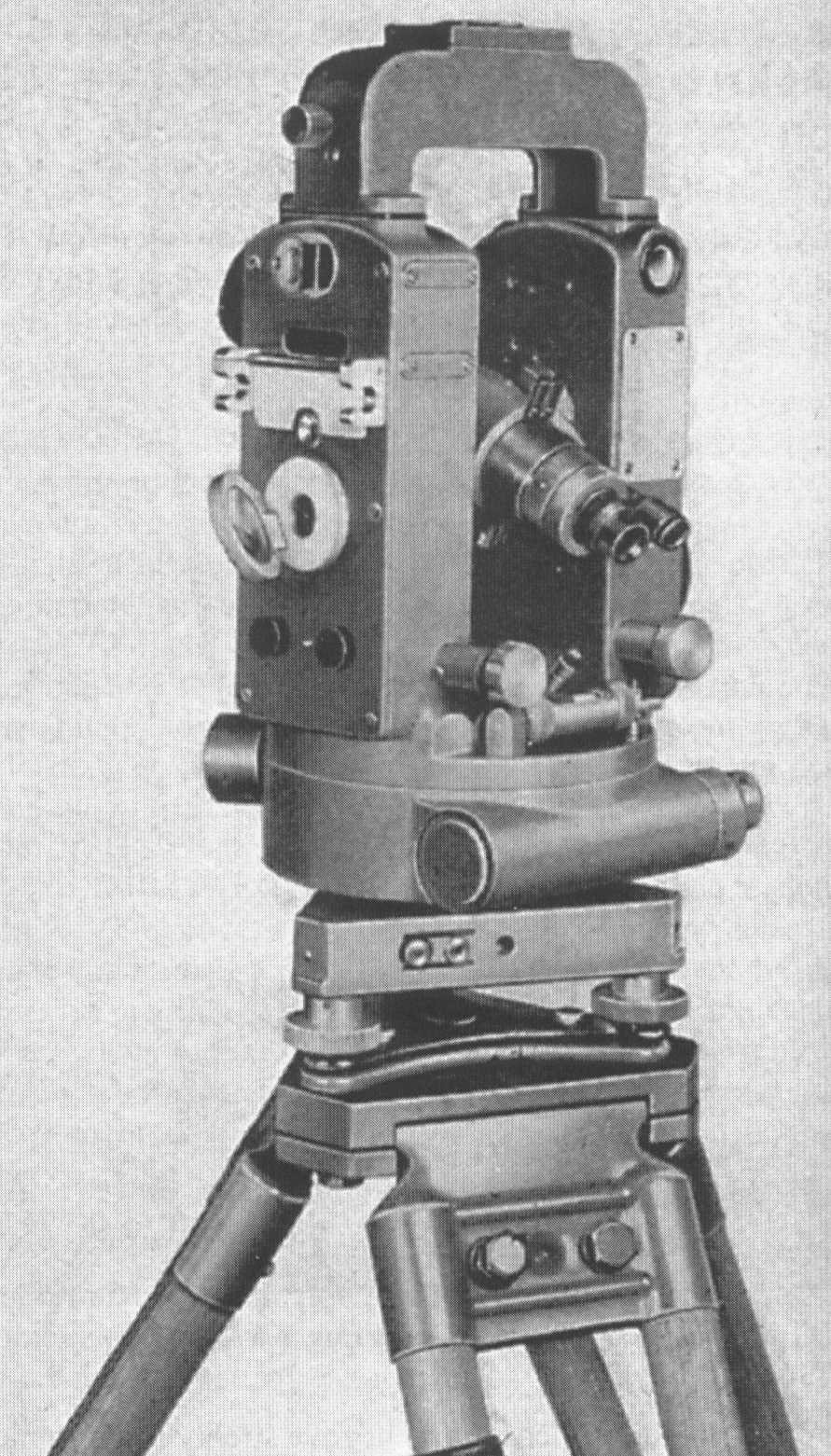
standard. In the catalogue from 1961, the modernized version of theodolite
TH 30 with metal rings and readings by verniers of 30² , but also a
construction of the theodolite Meopta T1c from 1955 with glass
rings and reading by simple optical micrometer enabling estimation of 2 mgon
(2cc). For the army it was equipped with a periscope. In the
catalogue there was also a balloon (meteorological) theodolite, a
topographic set, a base-measuring bar, a construction levelling instrument
NK 30x with a glass minute ring, an older small (the so-called pocket)
instrument KNK 8.8x, and the novelty MN 10x. There were also a plotting
cartographic set and plates there and a very popular triple pentagon.
In 1961, the Czechoslovakian professional public was
acquainted with the development of a quite new series of theodolites with
very good function and design. (Type MT 0, magnification 15x, reading of 5c,
MT 10, 28x, 1c, MT 11 with an automatic index of vertical ring,
MT 20, 28x, 10cc, and MT 30, 34X, 1cc). The series was
complemented with school and compass theodolites and of course with a
complete line of accessories. None of these instruments was used in
practice, because already in 1963 the production was suddenly abolishes and
delimited within the Council of Mutual Economic Help; the enterprise with
the new production programme was incorporated into the enterprise ZPA. The
situation in the production of levelling instruments was slightly better.
The new type MN 20 with a micrometer, designed for the accurate levelling,
and the building type MN 10 were developed and their production launched.
The last produced model was elegant MNK 20 for the technical levelling with
an automatic adjustment of measuring line by means of a compensator.
2.4. PHOTOGRAMMETRIC AND OTHER PRODUCTION
The tradition of photogrammetry is on the Bohemian
territory, which was a part of Austrian-Hungarian monarchy, very rich. After
the formation of Czechoslovakia, succesful civil firms were established; the
Czechoslovakian Military Geographic Institute continued in work launched by
the Military Geographic Institute in Vienna. The enterprise Koula in Prague
produced quality photogrammetric and photoreproductive instruments. On
commission of the army in 1930-1935, the enterprise supplied semiautomatic
and automatic aerial cameras, types A-I-25 and A-II-30, with the size of 13
x 18 cm, a blind shutter and a focus length up to 500 mm. Besides, there
were small instruments for a quick pictures evaluation: a sketch master, a
mirror stereoscope, and a drawing stereoscope. Another Prague’s firm
Haager supplied the army with a hand aerial camera, e.g. type A-VII-38. The
other Prague’s companies A. Löschner and V. Kolář also designed and
produced photogrammetric instruments before the II. World War. The Mahr-Kolář
rectifier with a bent optical axis leading to the considerable height
reduction was excellently designed, but it stayed only at the prototype
level. The Zbrojovka Brno Company produced in 1933 stereoautograph for a
terrestrial pictures evaluation in dimension of 6 x 9 cm.
Prof. F. Svoboda designed and with his co-operators
constructed the series of geodetic-astronomic instruments at the astronomic
observatory of CTU Prague. The mirror instrument, the so-called almukantar
for geographic latitude measuring from 1937, is the most known.
After the II. World War there were, besides the
enterprise Meopta, other small manufacturers. The aforesaid Research
Institute of Geodesy, Topography and Cartography constructed electronic
hydrostatic levelling sets HYNI, controlled by computer, and produced one of
the first prototype of luminous distance meters, supplied invar steel bands,
and it has produced an adapted construction of the so-called cirkumzenithal
till now. Ring tachymetric rules Cirta, polar coordinatographs and
orthogonal plotting sets were also produced in the enterprise Meopta.
Currently, reflecting prisms of distance meters and other small tools are
being produced in the Czech republic.
3. VERIFICATION OF QUALITY AND PARAMETERS OF HISTORIC
INSTRUMENTS
In years 1996-2000, six diploma theses dealing with a
verification and completion of parameters of the Czech production
instruments, mainly from the turn of the 19. and 20. centuries, as well as
with a determination of their quality in accordance with the Czech
International Standard (ČSN ISO 8322/1996) were defended at the
Department of Special Geodesy of the Faculty of Civil Engineering, CTU
Prague. Even if such a verification of exhibits does not give a precise
picture of their properties in the time of their practical usage, we presume
that they can considerably contribute to the classification of collection or
to the study and analysis of older engineering works yet.
The prerequisite of the verification, according to the
ČSN ISO Standard, is measuring with the tested instrument in two
different days, always in one series. Regarding theodolites, a series
consists of measurements of 4 horizontal directions, placed on the whole
ring in 3 groups without a closure, or a measurement of 4 vertical angles
measured on points with various elevations, respectively. The result are
standard deviations sφ of a horizontal direction and
vertical (or zenith) angle sζ, always for measurement in two
positions. For theodolites equipped only with the segment of a vertical
ring, the value sζ relates to the measuring only in one
position. Levelling instruments are for a determination of the standard
kilometre deviation skm of double levelling tested on the path,
long 240 m with stabilized lengths, sight line 20 m. One series consists of
5 two-ways measuring. The non-typical instruments, e.g. tubular liquid
clinometer or levelling diopter, were also tested by this procedure. The
magnification of telescope was determined in the laboratories of the
Department of Higher Geodesy. The constant of a cross-wires distance meter
and its addition constant were determined from the levelling of measurement
on the bases of the known lengths. The accuracy ranges from 0.1-0.2 of the
unit, 1-2 cm respectively.
In depositaries of NTM, the basic set of angular and
levelling instruments and the so-called universal levelling instruments,
nowadays called rather tachymeters (theodolites) with a sensitive levelling
tube, was chosen. The basic parameters of some instruments, chosen from the
whole set to characterize the given designed group, are shown in Tables 1,
2, 3 (Hánek 1999). Dimensions, mass weight, index levels sensitivity,
telescope lengths in the edge positions of focusing etc. are stated in
diploma theses.
Instruments were before the measuring carefully cleaned
and rectified, according to the original procedures. Because of the shortage
of original statives, the adapters on Zeiss statives were made. The common
bars with E division were used for levelling instruments. They were for
tubular clinometer and levelling diopters complemented with sliding circular
target, horizontally divided with a contrast colour. The level sensitivity
was determined from repeated measurements on the rectified rule with
accuracy of 1² approximately. At the cross alidade levels, the level
sensitivity perpendicular to the sight line is given at the first place,
after the slash a sensitivity of a longitudinal level or a level placed on
the telescope fork, follows. The sensitivity of striding levels or levelling
bubbles of theodolites is in Table 1 given with an abbreviation of location
in a column „other levels". In Table 2, there are levelling
instruments with a fixed telescope. The exception is the Spitra’s
instrument, equipped with the free telescope.
Table 1: Theodolites
|
Producer |
Type |
Year |
Purpose |
Magnifi-cation |
Standard deviation ["] |
Level sensitivity ["] |
Note: Multiplic. constant |
|
sj |
sz |
alidade |
others |
|
J.& J. Frič |
6R |
1907 |
Triang. |
30x |
5.8 |
- |
19.6/93.5 |
striding level not measured
. |
Screw microscope
|
|
40x |
4.0 |
- |
|
60x |
5.8 |
- |
|
J. & J. Frič |
9R |
1910 |
Polyg. |
30.0x |
8.5 |
8.9 |
30.6/50.0 |
15.0 levelling
bubble
|
100.2± 0.2 |
|
J. & J. Frič |
13RN |
1911 |
Tach. |
undetected |
31.8 |
not measured |
22.4/4.1 |
- |
100.2± 0.1 |
|
Srb & Štys |
No. 256 |
1927 |
Triang. |
26.1x |
3.6 |
- |
17.9/16.2 |
5.0 strid. |
Screw micr. |
|
Srb & Štys |
THN |
1939 |
Polyg. |
23.3x |
10.3 |
7.2 |
34.7/37.8 |
22.0 lev.b. |
100.4± 0.1 |
|
Srb & Štys |
THN |
1947 |
Tach. |
20.0x |
14.6 |
8.2 |
53.3/40.6 |
23.6 lev.b. |
100.0± 0.1 |
Table 2: Instruments for determination of elevation
|
Producer |
Construction |
Year of Production |
Sensitivity of levelling bubble ["] |
Rule [mm] |
Magnification |
Standard Deviation
skm [mm]
|
|
Spitra |
Tabular Liquid. |
2.half of the 19.cent. |
- |
800 |
- |
44.5 |
|
Božek |
Levelling diopter |
1838 |
90 |
860 |
- |
11.9 |
|
Spitra |
Levelling diopter |
1.half of the 19.cent. |
150 |
320 |
- |
19.0 |
|
Haase & W. |
Levelling diopter |
1880-98 |
46 |
310 |
- |
18.5 |
|
J. & J. Frič |
Levelling diopter, No 597 |
1899 |
34 |
315 |
- |
10.7 |
|
Spitra |
Levelling diopter |
The half of the 19.cent. |
25 |
- |
10x |
4.3 |
|
Haase & W. |
Levelling diopter |
2.half of the 19.cent. |
16 |
- |
8x |
6.3 |
|
J. & J. Frič |
Levelling diopter, No 866 |
1902 |
16 |
- |
44x |
1.8 |
|
J. & J. Frič |
Levelling instrument
No.1541
|
1908 |
21 |
- |
17x |
2.9 |
|
J. & J. Frič |
Levelling instrument, No.3630 |
1918-25 |
20 |
- |
28x |
2,6 |
Table 3: Universal tachymetres (with a sensitive levelling bubble)
|
Instrument |
No. |
Year |
Alidade Level/ Levelling Bubble ["] |
Magnification |
Standard Deviation |
Multiplic. constant |
|
alidade l. |
lev. bubb. |
sj ["] |
sz ["] |
skm [mm] |
|
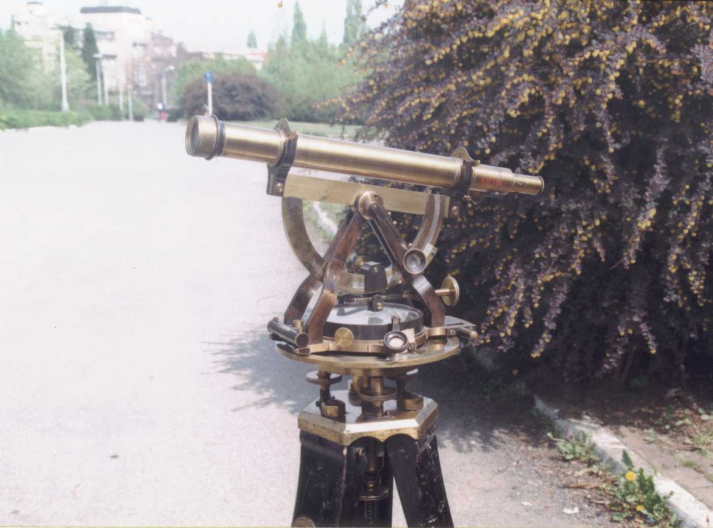
Brandeis |
40314 |
1860-70 |
102 |
damaged |
18x |
126 |
30 |
not meas. |
100.07 |
|
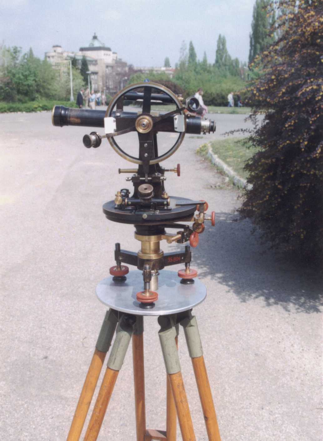
J. a J. Frič |
260 |
19./20. century |
58/65 |
17 |
19.2x |
60 |
45 |
12.7 |
99.94 |
|
J. a J. Frič |
4179 |
1925-30 |
129/142 |
13 |
25.7x |
10 |
17 |
1.6 |
no |
|
Haase & W. |
35658 |
1881-98 |
55/56 |
17 |
11.2x |
102 |
90 |
23.4 |
100.20 |
|
Haase & W. |
8964 |
1881-98 |
162/162 |
10 |
21.8x |
90 |
36 |
7.9 |
99.98 |
|
Haase & W. |
8965 |
1881-98 |
32 |
23 |
15.8x |
84 |
60 |
5.0 |
99.50 |
Instruments of the Haase & Wilhelm production do not have production
numbers; an inventory number of NTM is quoted
References
Frič J. & J., 1886: Der neue
Grubentheodolit "Duplex". Zeitschrift für Instrumentenkunde 6,
č.7, s. 221-232 a č.9, s.305-308
Hánek, P., 1994: A Renaissance Period Front-View
Map Depicting the Emperor Rudolph's Adit. Proceedings IX Congress ISM,
Prague, p. 158-161
The Czech Standard ČSN ISO 8322, 1996: Verification
of Surveying Instruments Quality in Investment Construction. Part 3:
Theodolites. Part 5: Levelling Instruments. (In Czech)
Švejda, A., 1997: Science and Instruments. In: Rudolph
II and Prague. Prague’s Castle Administration, Prague.
Hánek, P. - Švejda, A., 1998: To
the History of the Production of Geodetic Instruments in Bohemia. XXI
Congress FIG, Brighton. Papers from the ad hoc Commission History of
Surveying, s. 59-67, Papers from commission 1 & 11, p.417-425
Hánek, P., 1999: To the History of Surveying Instruments v Bohemia.
7. Mine Surveying Conference – Current Problems of Mine Surveying and
Geology. Association of Mine Surveyors and Geologists, Nový Hrozenkov,
p.49-56. (In Czech)
PICTURES
 |
Brandeis |
 |
Frih |
 |
Frih Dup |
 |
Meopta T |
 |
Schinzeu |
 |
Spitra |
 |
Stolle |
Ass. Prof. Pavel Hánek, PhD
Czech Technical University of Prague
Faculty of Civil Engineering,
Department of Special Geodesy
E-mail: hanek@fsv.cvut.cz
Dipl. Ing. Antonín Švejda
NTM Praha, vedoucí odd. exaktních věd
E-mail: antonin.svejda@ntm.cz
29 April 2000
|