|
|
||||||||||||||||||||||||||||||||||||||||||||||||||||||||||||||||||||||||||||||||||||||||||||||||||||||||||||||||||||||||||||||||||||||||||||||||||||||||||||||||||||||||||||||||||||||||||||||||||||||||||||||||||||||||||||||||||||||||
|
| (1) |
where D Xx are corrections due to various time changing effects (solid earth tide displacement including permanent effect, ocean loading, polar tides, post glacial rebound, atmospheric loading, seismic and volcanic effects, underground water level variations, geocenter variations), X0, t0 are coordinates and time of the initial epoch. To get the required relative accuracy 10-10, the corrections must be determined with the accuracy of about 1 mm.
Realizations of the ITRS are produced by the IERS under the name International Terrestrial Reference Frames (ITRF). These realizations consist of lists of coordinates and velocities for selected IERS sites. IERS is represented by successively improved realizations known as ITRF-YY published in the IERS Annual Reports for the year YY. From each annual frame labelled ITRF-YY a corresponding frame ETRF-YY can be derived which is represented by coordinates of sites belonging to ITRF and located in Europe.
2.5. World Geodetic System 1984
The terrestrial reference system used by the U.S. Department of Defense (DoD) for GPS positioning is WGS84. This global geocentric system is the fourth in a series of global geocentric coordinate systems defined by the DoD since 1960, see (Malys and Slater, 1994). The World Geodetic System 1960 was succeeded by improved systems in 1966 and 1972 and culminated in the development of the WGS84 fifteen years ago. This Conventional Terrestrial Reference System provides a coherent set of global models and definitions which form a basis for all current DoD mapping, charting, navigation and geodesy. It was originally based on TRANSIT Doppler observations performed by a globally distributed set of tracking stations. These TRANSIT satellite techniques provided a global reference frame with an estimated accuracy of 1 - 2 m. During the last decade the efforts by the worldwide scientific community, driven by scientific applications which require millimeter-level accuracy, have resulted in the development of highly accurate terrestrial reference frames (ITRF). In between, some DoD´s geodetic positioning requirements have demanded an accuracy approaching one decimeter accuracy level. For this reasons, the NIMA has been undertaking a review of WGS84 and has initiated a maintenance and enhancement effort to satisfy the more demanding DoD requirements for the accuracy and precision. This effort has included improved DoD GPS tracking station coordinates, refinements of the Earth gravity model, establishment of the improved WGS84 geoid (EGM96) as the preferred world vertical reference and an examination of the other models and parameters embodied in the definition of WGS84. After several improvements, which also included a more precise geocentric constant according to IERS standards, the last version, called WGS84(G873), coincides with the ITRF96 within a few centimeters. It is assumed that the future refinement activities will focus on an improved Earth gravity model and its associated geoid. Reference frame maintenance will be driven by plate tectonic motion and station relocations. The most demanding WGS84 users will find it necessary to incorporate models for tidal effects.
2.6 Transformations between Reference Frames
The relation between the International Celestial Reference Frame and the International Terrestrial Reference Frame is described by the formula
| (2) | XICRF = PNTXY . XITRF |
where P is the precession matrix, N is the nutation matrix, the matrix T expresses the rotation by a true sidereal time S and XY are the transformation matrixes from the terrestrial frame into the frame connected to the instantaneous ephemeris pole, XICRF is the vector related to the ICRF and, similarly, XITRF is the vector related to the ITRF axes.
The transformation formula between two terrestrial reference frames reads
| (3) | 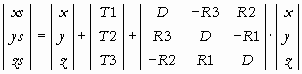 |
where T1, T2, T3 are the translations, R1, R2, R3 are the rotations and D is the scale coefficient. In Table 2.1 the numerical values of the transformation parameters between the latest realization - ITRF97 and the preceding realizations ITRF-YY are given. Note, that with regard to completely different way of forming ITRF93 the time changes "/y" must be introduced in transformations to this system. The ITRF 97 was created by combination of coordinates of more than 550 observing sites located in 325 places. The coordinate sets came from individual space geodetic techniques (4 VLBI individual solutions, 5 SLR, 6 GPS, 3 DORIS, 1 combined SLR + DORIS) collected by IERS in 1998-99.
Table 1. Transformation parameters between ITRF97 and preceding frames
|
Reference frame |
T1 |
T2 |
T3 |
D |
R1 |
R2 |
R3 |
Epoch |
|
ITRF88 |
1.8 |
0.0 |
-9.2 |
7.4 |
0.1 |
0.0 |
0.0 |
1988.0 |
|
ITRF89 |
2.3 |
3.6 |
-6.8 |
4.3 |
0.0 |
0.0 |
0.0 |
1988.0 |
|
ITRF90 |
1.8 |
1.2 |
-3.0 |
0.9 |
0.0 |
0.0 |
0.0 |
1988.0 |
|
ITRF91 |
2.0 |
1.6 |
-1.4 |
0.6 |
0.0 |
0.0 |
0.0 |
1988.0 |
|
ITRF92 |
0.8 |
0.2 |
-0.8 |
-0.8 |
0.0 |
0.0 |
0.0 |
1988.0 |
|
ITRF93 |
0.6 |
-0.5 |
-1.5 |
0.4 |
-0.39 |
0.80 |
-0.96 |
1988.0 |
|
ITRF94 |
0.0 |
0.0 |
0.0 |
0.0 |
0.0 |
0.0 |
0.0 |
1988.0 |
|
ITRF96 |
0.0 |
0.0 |
0.0 |
0.0 |
0.0 |
0.0 |
0.0 |
1988.0 |
The distribution of stations defining ITRF97 is displayed in Fig.1
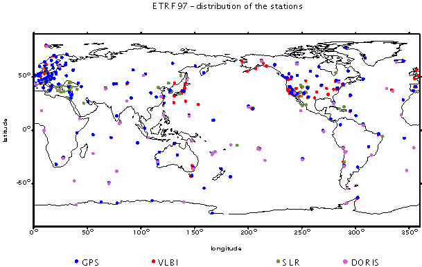
Figure 1
3. EUREF - EVOLUTION, CURRENT STATUS AND PERSPECTIVES
In the first phase of its employment GPS was only used as a new method of measurement in classical horizontal control networks. The benefits mainly resulted from its flexibility, efficiency, accuracy over long distances and from its economy as compared with other methods of measurements.
The request of GPS users in Europe for a new 3D reference frame became urgent to the end of eighties. Therefore in 1987 the IAG Section I (Positioning) had decided to form the new Subcommission for the European Reference Frame (EUREF) the goal of which was to develop a new GPS-based European Reference System. At the same time the CERCO (Comité Européen des Responsables de la Cartographie Officielle) Working Group VIII on Geodesy, independently of the IAG, came to the same decision. The new system, which started to be realized jointly by both authorities, should fulfil the following requirements:
- to represent a geodetic reference for any precise geodetic or geodynamical project on the European plate,
- to be a precise reference, very near to the WGS-84, for geodesy as well as all sorts of navigation in Europe,
- to be a continent-wide modern reference for multi-national Digital Cartographic Databases in Europe, which could not any longer be based on a variety of national datums over Europe.
As at that time the IERS combined SLR/VLBI solutions (ITRS/ITRF) were by far the best global realizations of a geocentric reference system, it was decided to base EUREF on the ITRF by selecting about 35 European SLR/VLBI sites for the epoch 1989. Thus, the European Terrestrial reference Frame (ETRF89), defined in this way, is a subset of the global solution ITRF89. Due to plate tectonic motion the coordinates of this subset of stations are slowly changing by about 2.7 cm/year. Therefore, it was decided that ETRF89 should rotate with the stable part of Europe so that the geometrical relations among stations are kept fixed. Obviously, as a consequence of that, the geometrical relations, defined in another reference system, may be slightly different. Therefore, the transformation parameters between the ETRF89 and other geocentric systems (ETRF-YY, ITRF-YY, WGS-84) have to be determined and regularly modified.
The main campaign of the project was carried out in 1989 for Western Europe and starting from 1991 the new reference frame was extended through a rapid sequence of post-campaigns to the territories of most European countries and adjacent areas. At present EUREF covers almost all European countries except Russia and Belarus and in most countries its intensive densification and update is in progress or has been accomplished. A review of the EUREF campaigns is given in Table 2 and the distribution of EUREF sites in Europe is depicted in Figure 2. Since EUREF as a whole is based on various campaigns carried out over a period more than 10 years, it seemed to be useful to introduce quality classes for sets of station coordinates coming from individual GPS campaigns. The quality class A means the accuracy level 1 cm with respect to the ITRF (ETRF) frame on the period 89 - 99, class B the accuracy level 1 cm at a given epoch and class C the accuracy up to 5 cm on the period 89 - 99.
Table 2. EUREF campaigns
|
No |
Name |
Time interval |
No of stations |
Country |
|
0 |
ITRF |
|
42 |
|
|
1 |
GPS EUREF 89 |
May 89 |
93 |
Europe |
|
2 |
Mobile VLBI 89 |
June-sept. 89 |
6 |
Europe |
|
3 |
EUREF NW 90 |
July-Aug. 90 |
39 |
North West |
|
4 |
EUREF CS/H 91 |
Oct.-Nov. 91 |
22 |
Czechoslovakia, Hungary |
|
5 |
Mobile VLBI 92 |
May-Aug. 92 |
8 |
Europe |
|
6 |
EUREF POL 92 |
July 92 |
30 |
Poland |
|
7 |
EUREF BAL 92 |
Aug.-Sept.92 |
24 |
Baltic |
|
8 |
EUREF BUL 92 |
October 92 |
14 |
Bulgaria |
|
9 |
EUREF GB 92 |
October 92 |
31 |
G. Britain |
|
10 |
EUREF CYP 93 |
January 93 |
11 |
Cyprus |
|
11 |
EUREF D93 |
May 93 |
27 |
Germany, Netherlands |
|
12 |
EUREF F93 (RRF93) |
March-April 93 |
23 |
France |
|
13 |
EUREF LUX BD94 |
March 94 |
19 |
Luxemburg, Belgium, Germany |
|
14 |
EUREF SLO/CRO 94 |
May-June 94 |
22 |
Croatia, Slovenia |
|
15 |
EUREF DK 94 |
Aug.-Sept. 94 |
12 |
Denmark |
|
16 |
EUREF Ukraina 94 |
Jun 94 |
14 |
Ukraina |
|
17 |
EUREF ROM 94 |
Sept. 94 |
17 |
Romania |
|
18 |
EUREF NOR 94/95 |
Sep-Oct 94, |
87 |
Norge |
|
19 |
EUREF A 94/95 |
Oct 94/95 |
17 |
Austria |
|
20 |
EUREF EIR/GB 95 |
April 95 |
24 |
Ireland, GB |
|
21 |
EUREF Iberia 95 |
May 95 |
43 |
Spain, Portugel |
|
22 |
EUREF Iceland 95 |
July 95 |
191 |
Iceland |
|
23 |
EUREF FYROM 96 |
Aug 96 |
10 |
Macedonia |
|
24 |
EUREF Malta 96 |
Oct-Nov 96 |
13 |
Malta |
|
25 |
EUREF Balear 98 |
April 98 |
6 |
Baleares |
|
26 |
EUREF Alb., BH, Yug. |
Sept. 98 |
29 |
Albania, Bosnia-Herz., Yugoslavia |
|
27 |
EUREF Moldova |
May 99 |
5 |
Moldova |
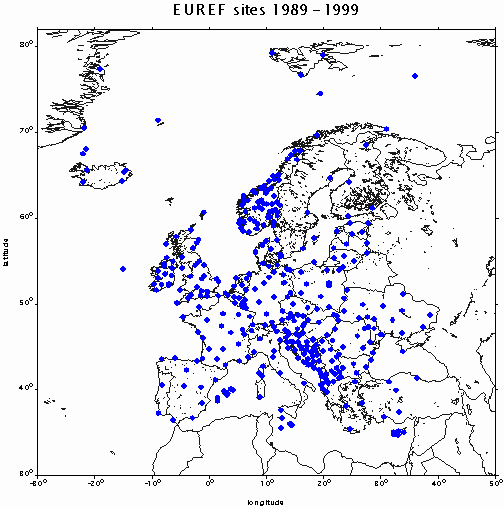
Figure 2
The densification and maintenance of EUREF is mainly being done by GPS and it benefits from growing number of permanent GPS stations in Europe. These stations are in general being established for
- providing link between ETRS/ITRS and the national (local) reference system through EUREF/IGS,
- surveying applications based on post-processing,
- real-time navigation and/or surveying on different accuracy levels (DGPS, RTK ...),
- deformation monitoring (post-glacial uplift, tectonic movements along active faults).
Most of these permanent stations are not a part of the global IGS network and therefore in 1995 the EUREF Symposium, in response to the IGS "Call for Densification of the ITRF through Regional GPS Analysis as IGS Network Associate Analysis Center", proposed to the IGS to consider the EUREF permanent network to be a European densification of the global IGS network. The proposal was officially accepted by the IGS in May 1996. In this connection EUREF guaranteed a routine analysis of the data from all permanent European sites on the basis of distributed processing. The work is ensured by 10 EUREF Local Analysis Centers which submit weekly solutions for a particular EUREF subnetwork to the EUREF Regional Analysis Center (CODE, Bern) which is responsible for combining these weekly free-subnetwork solutions into one European solution delivered to the IGS. In May 1997 the CODE analysis center delivered its first yearly EUREF solution to the IERS and since that time all EUREF permanent sites have been included in ITRS realizations and it has been possible to use them as core stations for analysis of EUREF campaigns. Initially the network consisted of about 50 permanent sites and today nearly 90 European permanent GPS stations are regularly contributing to the European combined solution. Some of them are providing hourly data files for meteorological GPS applications. The work of the EUREF Permanent Network is coordinated by the Royal Observatory of Belgium and now it is in transition towards the EUREF Network Service which should consist of permanent stations, data centers, analysis centers, an executive board, a central bureau and of special projects.
4. EUREF AND NATIONAL TERRESTRIAL REFERENCE SYSTEMS
As it already has been said, there is a little doubt that GPS allows a completely new efficient approach to the establishment of a 3-D reference frame ensuring very precise and homogeneous positioning over the entire globe. In Europe the rapid development during the last decade has in most countries resulted in a situation where the geodetic control networks of the new generation (ETRF) coexist with classical horizontal and vertical control networks which are still being used by a very large number of users using advanced terrestrial surveying techniques. While the first are characterized by a very high degree of both accuracy and precision, homogenity and integrity and by the density ranging in different European countries from 1 point per 50 km2 to 500 km2 depending on the actual status of the densification process, the second are distinguished by the classical distinction between the horizontal and the vertical component, by the reference to the national horizontal coordinate frame and national vertical datum, by the density of 1 point/2-20 km2 depending on the area of the country, by the accuracy by one order worse as compared to the GPS based frames and usually also by a poor homogenity. At present there are 46 countries in Europe and, according to Grothenn (1994), 5 different reference ellipsoids and at least 8 cartographic projections.
Obviously, the first task is to provide transformation parameters between the national terrestrial reference system and ETRF. In this respect the problem is usually reduced to an optimal choice of the transformation routine and of the number and distribution of the identical points. Both aspects are directly related to the area and shape of the territory. But from the above mentioned coexistence an inevitable question must always arise - how can the precise and homogeneous GPS based reference frame be used for the improvement of the classical terrestrial frame? With respect to the surveying and geodetic "tradition", to the existing map work, to the economical point of view and to present needs of the surveying community the contemporary coordinate frame should, in general, fulfill the following requirements:
- to allow a direct use of GPS techniques, i.e. to be represented by a set of geocentric coordinates,
- to allow the use of advanced terrestrial classical surveying techniques, i.e. to be represented by a set of plane coordinates referenced to the national user map projection,
- to allow the use of existing map work in scales 1:1000 and smaller without changes,
- to meet the needs of engineering and cadastral surveys and of GIS/LIS data locations,
- to make an extensive use of the existing reference systems.
Nowadays, each European country, which has joined the EUREF project, has the opportunity to improve the accuracy of the present geodetic network, to obtain high accuracy coordinates of tens of thousands control points and, in addition to it, to obtain the ETRF coordinates of all these points on the accuracy level of the improved terrestrial coordinate frame through a suitable transformation. Different strategies can be used for the improvement of terrestrial control networks through ETRF reference frame. In the following one possible approach is illustrated on the example of the Czech Republic.
Transformation (B,L,Hel)ETRF89 Þ (x,y,Hn)national
(B,L,Hel)ETRF89Þ (1)Þ (X,Y,Z)ETRF89Þ (2)Þ (X,Y,Z)nationalÞ (3)Þ
Þ (B,L,Hel)national Þ (4)Þ (x,y)national
(Hel)Þ (5)Þ (Hn),
where (1) is the transformation between the ellipsoidal and cartesian coordinates, (2) is the 3-D Helmert (7-parameter) transformation, (3) is inverse to (1), (4) is the national map projection (in this case conformal oblique conical projection) including the polynomial distribution of the residuals D x, D y obtained after transformation.
A transition from ETRF89 to the national reference system (S-JTSK), represented by the plane coordinates resulted from the oblique conformal conical projection of the Bessel ellipsoid, has been realized by two-step transformation. First, the 7-parameter Helmert transformation was used with a consequent application of the national map projection to the transformed ellipsoidal coordinates to obtain the plane coordinates x,y. Second, the residuals D x, D y, which can in this case reach up to 60 cm, have been distributed by a polynomial approximation. The approach is described by the following flow diagram and the results are illustrated in Fig. 3. In Fig. 4 the residual vectors, covering a part of the territory and coming from the transformation of directly observed ETRF89 coordinates to the improved national coordinates, illustrate the accuracy of the "improved" national terrestrial reference frame.
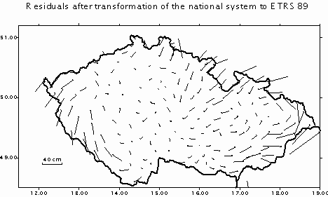
Figure 3
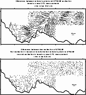
Figure 4
5. GPS AND EUROPEAN HEIGHT DATUM
In Europe there are at present national height systems with different datums (zero levels represented by reference tide gauges) and with different kinds of heights. Over 40 European countries use altogether 19 reference tide gauges the differences of which with respect to the UELN reference tide gauge (Amsterdam) vary from +16 to -231 cm, see (Sacher et al., 1999). The tide gauge stations of the European national height systems are located at various oceans and inland seas - Baltic Sea, North Sea, Mediterranean Sea, Black Sea, Adriatic Sea, Atlantic Ocean. It should be noted, that the used height datums often are of historical nature and that not all zero points are referred to the mean sea level. Some zero points are referred to the low tide (Ostend) or to the high tide. For example the Amsterdam zero point is referred to the mean high tide in 1684. About 50% of European countries use normal heights, 35% orthometric heights and about 15% normal orthometric heights.
Along with the unification of the GPS reference frame the CERCO urgently requires the realization of a uniform European Height System for unified Digital Cartographic Data Bases. The new system will be based on normal heights and will be referenced to the Amsterdam Tide Gauge. Since 1994 also this task has been solved within the EUREF Subcommission. The approach follows two aspects. The first is the "extensive" and "intensive" enlargement of the UELN (Unified European Levelling Network), which means the incorporation of both primary levelling networks of the new (Central and East European) countries and lower order levelling networks of all European countries. The second is the realization of an extensive GPS project aimed at the interconnection of all European height datums.
In Europe there are at present two continental levelling networks co-defining two height systems - the Amsterdam and the Baltic Height System. The first continental network is UELN, the second one is UPLN (United Precise Levelling Network) which covers the European part of the former Soviet Union and the territories of several European countries of the former Soviet block. The UPLN consists of the first order levelling lines passing through Bulgaria, the Czech Republic, East Germany, Poland, Slovakia, Hungary, Belarus, Estonia, Latvia, Lithuania, Ukraine, Moldova, Romania, Russia and Georgia. The UPLN was first observed in fiveties and re-observed in seventies. It comprises over 350 of nodal points, the observables entering the adjustment were normal height differences and the reference tide gauge is Kronstadt (Russia). The establishment of the UELN started in early seventies, the re-adjustment was carried out in 1986 and a new project of the extension and densification of the UELN with its repeated re-adjustment was launched in 1995 (UELN-95). The continuous re-adjustment should result in the development of a "kinematic height network". The observables in the adjustment are geopotential height differences, the estimated parameters are geopotential numbers. Such an approach gives a possibility to get easily from geopotential unit an arbitrary kind of height. In 1998 the UELN comprised more than 3000 nodal points. The problems to be solved are the further extension of the network to the Black Sea and strengthening the Great Britain and Scandinavian blocks by incorporating more levelling links and levelling networks of Baltic countries.
The objectives of the EUVN project are basically to contribute to the unification of European height systems on the accuracy level of a few centimeters, to provide fiducial points for the European geoid determination, to connect the European tide gauges for investigations of sea level variations and to prepare a European geokinematic height reference system. The EUVN connects three European networks - two levelling (UELN and UPLN) networks and the EUREF network.
The initial phase of the project, called EUVN97, was carried out in 1997/1998 as a joint venture of all European EUREF countries. The total of 217 EUVN sites, distributed over almost all European countries, comprises 37 permanent stations, 79 EUREF sites, 53 first-order levelling bench marks (nodal points) and 63 tide gauges. All EUVN sites were tied to the first-order national levelling networks. The GPS campaing was simultaneously carried out at all these sites from May 21 to May 29, 1997. Distribution of stations is depicted on Figure 5. The observations were processed by distributed processing carried out by 8 analysis centers, the final combined solution was performed by two combination centers (BKG Leipzig and CODE Bern). Three processing strategies were followed, one of them being accepted as "official". The accuracy of the resulting "GPS height component" with respect to the ITRF definition sites is characterized by the r.m.s. residual after Helmert transformation equal 5 mm, the daily repeatability is 4 - 5 mm. A realistic accuracy estimate may be worse but in any case the accuracy of the height components of EUVN sites is better than 10 mm. The project is to be continued by collecting related levelling and gravity data.
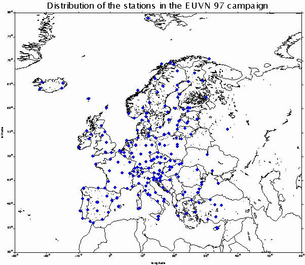
Figure 5
6. GPS HEIGHTING AND GEOID IN EUROPE
As it is known that the definition of sea-level heights on land is implicitely linked to the geoid (orthometric heights) or quasigeoid (normal heights), a new regional or global vertical datum can be defined with (quasi)geoid as the zero reference surface.Thus, both the land elevations and ocean depths can be defined with global geodetic consistency. Once the new definition of the reference surface is adopted, sea level heights can be computed with respect to it and/or can be directly surveyed using GPS at an arbitrary place of the globe in the future.
A feasibility of GPS heighting strongly depends on the quality of the geoid model for the territory under study. This model must be fitted to both the GPS reference frame and the levelling network co-defining the height system of the respective territory. Making a precise and homogeneous geoid model of a continental extent is a rather complicated problem due to poor gravity data availability for the entire continent.
Simultaneously to the GPS and levelling interconnection of different European height datums the investigations towards construction of a very precise high resolution (quasi)geoid model for Europe are being done. The best presently available global geopotential model, from which geoid heights can be computed, is EGM96 (360,360). It was developed in a joint effort of the NIMA (DoD, USA) and NASA GSFC. The model is based on satellite tracking observations, terrestrial gravity anomalies and satellite ERS-1/TOPEX/POSEIDON altimeter data (Lemoine et al., 1997). Several methods of testing have been used to assess the accuracy of this model. For Europe the rms error amounts about 0.3 m after elimination of the bias and trend but there are several geopotential anomalies exceeding 0.75 m (see e.g. Burša et al., 1998).
On the basis of EGM96 a new quasigeoid solution EGG97 was computed for entire Europe at the Institut für Erdmessung, University of Hannover. For the long wavelength gravity field information the geopotential model EGM96 was employed whereas the short wavelength gravity field components were modeled using the residual terrain model reduction technique, where the reference topography was constructed by an average filter moving along a 15´grid, see (Torge and Denker, 1998). The numerical evaluation of the integral formula with residual gravity anomalies was done by spherical 1D FFT technique. The EGG97 model constitutes a significant improvement over older models due to employment of high resolution gravity and terrain data and availability of high quality global model. For areas with a good coverage and quality of the gravity and terrain data the accuracy of a new solution is estimated to be 1 - 5 cm over 10 - 100 km distance and 5 - 20 cm over 1000 km distance. By comparison with GPS/leveling data medium and long wavelength (over 100 km) errors have been found. These can be mainly attributed to errors of the global model but also systematic errors in the gravity data are possible in some regions. Future improvements may come from the results of new space missions, improved gravity coverage and from combined solutions with GPS/leveling geoid heights as soon as a homogeneous data set for Europe becomes available.
7. EUREF AND ITS USE IN NAVIGATION AND GIS
The growth in air transport seen in the last two decades indicate that air traffic movements in Europe will more than double by 2015 compared with those in 1997.This will maintain a continued pressure to upgrade the capacity of the European Air Traffic Management system. A navigation strategy for the European Civil Aviation Conference (ECAC) member states has been developed and agreed for the period 2000 - 2015. An important part of this strategy is represented by issues related to geodetic reference systems and geographic coordinate data. The first issue involves the availability, consistency and integrity of global terrain and obstacle data, along with the horizontal and vertical reference systems and frames to which they are associated. The second looks at issues of geographic data for GNSS in the Terminal Control Area, associated with approach, landings and departures along with their relationships to aerodromes, terrain and obstacles data.
In Europe the implementation of a common horizontal reference frame has been adopted for navigation facilities. The EUREF network provides high quality European solution with Navigation Critical Data determined and published for European states. Terrain and obstacle data are still held primarily in the national mapping systems. Whilst transformation parameters may be available to convert this data, this relies upon the availability of the source data in electronic format. A number of issues ned to be evaluated for the harmonisation of related geographic data.The issues for both the horizontal and the vertical reference systems will need to be considered. With regards to data availability, the following points need to be assessed: the availability and feasibility of consistent European digital terrain data sets; transformation parameters between reference systems; data quality, its validation and verification; error analysis; availability of precise geoidal models for Europe; cost benefit analysis; data quality risks. With respect to reference systems and frames the following points need to be assessed: agreed European and global definition of a unified vertical reference system and frame; the European level of adoption of the unified horizontal and vertical reference systems and frames for mapping and terrain data; national policy with regards to national datums and ETRF for national mapping and positioning requirements; anticipated migration from national vertical datums and height systems towards a unified vertical system.
Another example of importance of unified geodetic information is the pan-European project LaClef. It is aimed at finding ways of unlocking some of the valuable data held in the public sector. One of its objectives is to demonstrate how an effective pan-European multi-sector service can be developed and successfully integrated. It will build on existing European initiatives, among them on MEGRIN (Multipurpose European Ground Related Information Network) distributed geographical database to identify how an effective geographical information metadata and on-line data supply service can be developed. The LaClef service will provide a variety of search and query tools to interrogate the metadata. A coordinate search and geographical search will be two of the most important facilities. The users may select the coordinate reference frame of their choice and input the relevant window coordinates or alternatively select an area from a geographic representation. Additionally, the project will offer a coordinate transformation service. Two main categories of such a service are envisaged:
- geodetic coordinate user support - the main objective will be to help users to identify and understand the geodetic reference systems and coordinates used at the national or international level and give them guidance and tools to transform data from one system to the other,
- localisation and calculation - additional services such as distance and surface computation, coordinate calculation of features; the additional functionality to be considered is related to geographic data transfer format translation, point data conversion, datum transformations, map projection conversion, coordinate conversion.
A possible role the EUREF project may play in the realization of the LaClef concern several geodetic aspets - data gathering (collection of all European coordinate systems with the appropriate parameters and algorithms), data use agreements, definition of maintenence procedures, design of calculation algorithms, data validation, coordination with relevant European expertise.
8. REFERENCES
BOUCHER C., ALTAMIMI Z., FEISSEL M., SILLARD P. (1996): Results and analysis of ITRF94. IERS Technical Note 20. Observatoire de Paris, March 1996.
BOUCHER C., ALTAMIMI Z. (1999): Report on ITRF97 data analysis. IERS 1999. (http://lareg.ensg. ign.fr/ITRF/ITRF97-rep.htm).
McCARTHY D. (ed.) (1992): IERS Standards 1992, IERS Technical Note 13, Observatoire de Paris, 1992.
McCARTHY D. (ed.) (1996): IERS Conventions 1996, IERS Technical Note 21, Observatoire de Paris, 1996.
BRUYNINX C. (1999): Status and Prospects of the Permanent EUREF Network. Presented at: EUREF Symposium 1999, Prague, The Czech Republic, June 2 - 5, 1999.
EUREF WEB site: http://www.oma.be/KSB-ORB/EUREF
SEEGER H. (1997): The Current Status and Perspectives of EUREF. Presented at: XXII General Assembly of the European Geophysical Society, Vienna, Austria, 21 - 25 April 1997. Reports on Geodesy No. 3 (26) 1997, pp. 31 - 76.
ALTINER Y. (1999): Results of the EUREF98 GPS Campaigns in Albania, Bosnia and Herzegovina and Yugoslavia. Presented at: EUREF Symposium 1999, Prague, The Czech Republic, June 2 - 5, 1999.
RÜDJA A. (1999): A New ETRS89 Realization for Estonia. Presented at: EUREF Symposium 1999, Prague, The Czech Republic, June 2 - 5, 1999.
HUGENTOBLER U., GURTNER W. (2000): Moldova EUREF Campaign 99. Presented at: EUREF TWG Meeting, Brussels, March 20 - 21, 2000.
SACHER M., IHDE J., SEEGER H. (1999): Preliminary Transformation Relations between National European Height Systems and the UELN95. Presented at: EUREF Symposium 1999, Prague, The Czech Republic, June 2 - 5, 1999.
CIMBÁLNÍK M., KOSTELECKÝ J. (1996): Direct Transformation between the ETRS-89 and the Czech Cadastral System S-JTSK. Report on the Symposium of the IAG Subcommission for the European Reference Frame (EUREF) held in Ankara, 22 - 25 May 1996. Veröffentl. der Bayer. Komm. für die Intarnationale Erdmessung der Bayer. Akad. der Wissenschaft., Heft Nr.57, München 1996, pp.325 - 330.
LEMOINE F. et al. (1997): The development of the NASA GSFC and DMA joint geopotential model. In: J. Segawa, H. Fujimoto, S. Okubo (Eds), Gravity, Geoid and Marine Geodesy, IAG Symp., Vol. 117, pp. 461 - 469, Springer, Berlin, Heidelberg, New York.
BURŠA M. et al., (1998): Accuracy estimates of EGM96 with emphasis on Central EUROPE, Scandinavia and Baltic region. In: M. Vermeer, J. Ádám (Eds), Second Continental Workshop on the Geoid in Europe, Budapest, Hungary, March 10 - 14, 1998, pp. 81 - 86, Rep. of the FGI No. 98:4, 1998.
TORGE W. and DENKER H. (1998): The European Geoid - Development over More than 100 years and Present Status. In: M. Vermeer, J. Ádám (Eds), Second Continental Workshop on the Geoid in Europe, Budapest, Hungary, March 10 - 14, 1998, pp.47 - 52, Rep. of the FGI No. 98:4, 1998.
MSc. Jaroslav Šimek
Prof. MSc. Jan Kostelecký, DSc.
Research Institute of Geodesy
Topography and Cartography
Geodetic Observatory Pecný
E-mail: gope@asu.cas.cz
Home page: http://www.vugtk.cz
18 April 2000
![]()
This page is maintained by the
FIG Office. Last revised on 15-09-04.