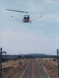
AERIAL SURVEY OF FIX ASSETS IN THE RIGHT-OF WAYHuug HAASNOOT, the NetherlandsKey words: LiDAR, Corridor Mapping, 3D-geometry, Ortho-rectified, geo-referenced video images, Automatic Filtering Routines, Synchronised video imagery. AbstractHigh density airborne LiDAR, being an innovation in remote sensing techniques, have now taken away the barriers of the traditional survey techniques. Especially for long corridors like roads, railway and electricity lines, laser alitimetry provides a new survey method to collect remotely sensed data in a quick way. In this lecture emphasis will be put on LiDAR systems which operate with the latest technology at low altitude (50-70 m) and low speed (50 km/hour) which results in a survey tool that can compete with traditional survey methods as it is precise (5-8cm absolute accuracy), reliable, fast (150 km per day) and cost-effective. The advantages of aerial surveys are twofold: obviously the safety aspect is very important as surveyors are not required to physically occupy the area and secondly for the train / road operators it is essential that the survey will not interrupt the schedule of the transport. Further aerial surveys are not compromising the environmental conditions, nor any permits are required to have access to every property.
A dedicated processing package supplies filter algorithms and CAD functionality "on top of" the laser data as well as fully synchronised video imagery, providing additional capabilities to the operator in extracting valuable information from the LiDAR data. This extracted information can easily be incorporated in external specific GIS or CAD software packages. As long corridors do not lend themselves well to conventional land survey techniques, this new high-detail aerial survey method has been used successfully world-wide with a total of more than 13,000 survey kilometres. During the last 1.5 years projects have been completed in various industries with a variety of endproducts, e.g. detailed Digital Terrain Models with more than 10 points per m2 for flood control, planning of new roads for the expansion of tourism on French Polynesia, high-accuracy cross-profiles of the Expressway near Kuala Lumpur, planning of noise protection walls for the German railroad, coast line protection survey in Portugal. In more detail a major project executed for Spoornet, the South African railway division of Transnet, will be discussed during this presentation session. This project comprised of surveying 3 875 km of heavy haul railway lines covering all fixed assets in the right-of-way. The purpose was to define the accurate geographic position and attributes of all fixed assets in order to build an integrated information system to manage and maintain the fixed railway assets. Given the inaccuracies and incompleteness of the historic asset records, the decision was made to re-survey Spoornet's mainlines. As conventional landsurvey methods were more expensive and time consuming, the project was executed with FLI-MAP, the laser altimetry system from Fugro, in close liaison with the Chair of Railway Engineering at the University of Pretoria (South Africa), Prof. Ebersöhn. BIOGRAPHICAL NOTEHuug Haasnoot has more than 12 years experience in the survey industry after graduating in 1988 from the Technical University of Delft, The Netherlands, with a MSc. in Geodesy. He is currently working for Fugro-Inpark B.V. in the Netherlands and as Director of the division FLI-MAP® responsible for all corridor mapping projects with the laser altimetry system FLI-MAP® in the Eastern Hemisphere. Fugro-Inpark B.V. is an engineering and consultancy company, offering expertise and project support in the areas of geographic information systems, and their applications to photogrammetry, subterranean infrastructure, telecommunications, railroad industry, electricity utility industry and civil engineering. CONTACTHuug Haasnoot 23 March 2001 This page is maintained by the FIG Office. Last revised on 15-03-16. |