A GIS SOLUTION TO LAND CONSOLIDATION TECHNICAL PROBLEMS IN MOROCCOEl Hassane SEMLALI, MoroccoKey words: land consolidation, reallocation, conceptual data model, CONGOO, database, GIS, parcel, soil classes, precision. 1. INTRODUCTIONAgriculture plays an essential role in restructuring and country planning. However, the agricultural world undergoes economic pressures that act on the efficiency of landowners. To insure a good productivity, the farmer needs a space spatially organized and well fitted. To fit the agricultural rural space, it is first well to know it, and therefore to collect and distribute information that concerns this space. Data on this space are in continuous expansion, what makes their management and their manipulation increasingly difficult. Nowadays, the development of GIS technology renders this task easier and contributes efficiently to the improvement and the management of agricultural spaces. In Morocco, the agriculture constitutes a fundamental development parameter and occupies an essential place in the national economy. Among important agricultural projects, land consolidation constitutes a dynamic mean for the development of the rural world. It finds its importance especially where the mechanized agriculture feels difficulties to reach a good profitability in the exploitation of earth. Unfortunately, in Morocco land consolidation projects do have a great number of problems, on the administrative plan as well as on the technical plan. Among important technical problems there are: methodologies used in the establishment of basic documents, combination of data of different precisions, imposed constraints, computational problems, landowners claims and difficulties encountered in the establishment of the final reallocation project. Administrative problems are not discussed in this context. Our objective in this study is to show the contribution of GIS to find a solution to these technical problems. This solution concerns especially land consolidation in irrigated areas, it is based on five main key points:
2. A CONCEPTUAL DATA MODEL FOR LAND CONSOLIDATIONDatabase design is a delicate operation that necessitates an important investment. Methods of database design are composed of several stages that remain similar through the different available methods. The development of a database passes through four levels. The external level, the conceptual level, the logical level and the internal level. In this article, we will focus on the conceptual level because it is the basis for the conception process. At this level, we describe information to manipulate and their organization independently of the physical storage, so that the same conceptual model may be appropriate for several physical implementations (Laurini and Thompson, 1993). A conceptual data model is the representation of the whole data of an area, without taking into account economic and technical aspects, and without referring to conditions of utilization by such or such processing. The principal objective of a conceptual data model is to identify and describe objects of the studied area and their relationships. The conceptual level terminates by the establishment of Conceptual Data Model (CDM) using a formalism. The formalism we are using in this study is CONGOO (CONception Geographique Orientée Objet). It is applied to data having spatial graphic representation as well as to other types of data. In this formalism the basic components used to represent data of the real word are layers, classes, objects, relationships between different data, and integrity constraints. CONGOO distinguishes two types of topological relationships between all spatial objects, superposition and neighborhood, these facilitate processing imposed by spatial researches not defined a priori (Pantazis and Donnay, 1996). 2.1 Identification and description of geographical objects in land consolidationAccording to this formalism, the established CDM contains 2 layers of geographical objects, 20 classes, 29 objects, 4 relationships of structure, a constraint and near two thousands of topological relationships. The established model is an original model that combines and presents the past and the present of a project of land consolidation (Semlali, 1999). It contains data before and after land consolidation, as well as relationships that exist between the two situations. Data before land consolidation are two layers and six classes. Layers are EXCLUS and EAU. Classes are SECTEURS, PARCELLES, SOLS, ROUTES, PISTES, PUITS, and PT_CONTROLE. In the situation after land consolidation, we find the same two layers. The classes SECTEURS, SOLS, ROUTES, PUITS and PT_ CONTROLE are also kept without change. New classes in the new situation are PARCELLES_AT, BLOCS, and CAANAUX_IRRIGATION. The class PARCELLES transforms to a new class which is PARCELLES_AT that constitutes the class BLOCS. This model can serve for the control of errors such that the control of areas within a sector of land consolidation. The sum of areas of all instances of EXCLUS, EAU, PARCELLES and ROUTES, has to be equal to the area of the class SECTEURS. The sum of areas of the class PARCELLES_AT should be inferior to that of the class PARCELLES on the one hand, and inferior or equal to that of the class BLOCS on the other hand. 3. A PROTOTYPE DATABASEAt the logical level, we use models of the conceptual level to describe information as function of software used for the installation of the database. In other words, it is a transformation of the conceptual model with the tools offered by the logical modeling. In our study, a prototype database is built using the georelational vector model of the ArcInfo software. The spatial information identified in the conceptual level is assigned the corresponding entities in ArcInfo representation. Entities are classified as function of their geometric representation, such as point, line and polygon. ArcInfo uses coverages to represent vector data layers. Classes and layers of the conceptual data model are transformed into equivalent coverages, and the necessary related attribute tables are formed, these data constitute the structure of the prototype database (Semlali, 1999). 4. SOLUTION TO COMPUTATIONAL AND OVERLYING PROBLEMSA project of land consolidation is composed by several phases. Among these phases, reallocation is an operation that involves several criteria and has to take into account some constraints. At this level plan we have proposed a methodology of reallocation that exploits the analysis functions offered by ArcInfo. This methodology has for goal to seek solutions to imposed constraints such that:
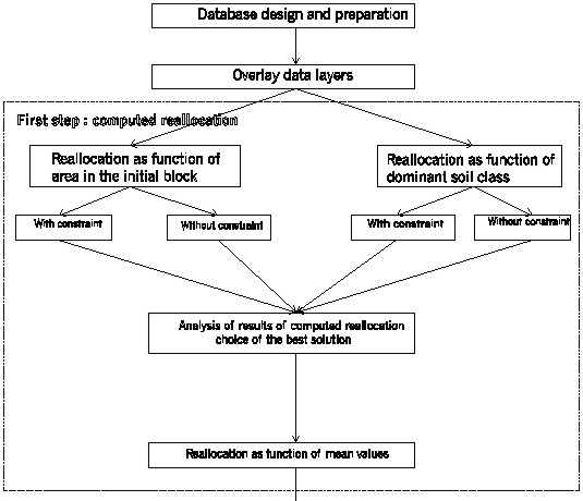
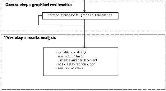
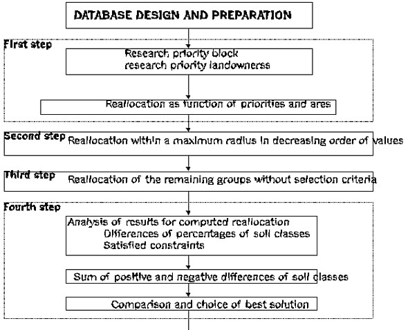
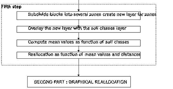
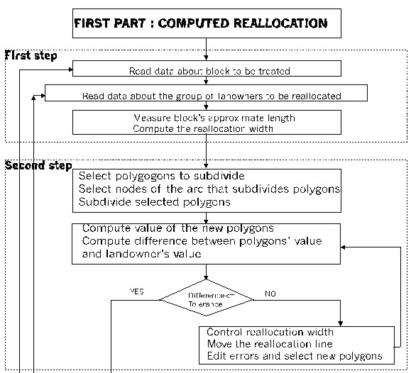
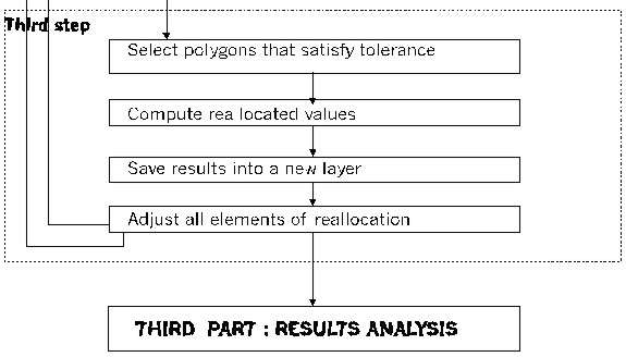
4.1 Methodology for land reallocationIt is of course impossible to reply to all these constraints. Therefore it is necessary to fix a choice in order to find the new position that responds to constraints in decreasing order of importance. This choice has to be identical to put all landowners on the same level of equality. In the proposed methodology, we suppose that if a majority (more than 50%) of landowners are reallocated according to the conditions above, this can be considered as a success in the realization of a land consolidation project in Morocco. In this methodology we separate land reallocation operations into three great parts: the computed reallocation, the graphical reallocation and the analysis of the results. Figure 1 describes different steps of this methodology. In the first part, we compute new positions of land ownerships within irrigation units as function of chosen constraints. In this part, we propose four computation methods. Each method tries to respond to a criterion and takes into account constraints that the user desires to satisfy. This part terminates with an analysis of the obtained results by the four methods. The user can then choose among these methods one that gives a good redistribution of soils and a result that satisfies the constraints chosen, details on this part are presented by figure 2. The second part is based on results of the preceding part, it consists in determining graphically the exact position of the new parcels by respecting tolerances on reduced values, figure 3 shows most important steps of this part. The third part concerns the analysis of results by comparison of the situation before reallocation to that after reallocation according to criteria chosen at the departure. Used criteria are of two types: First type: criteria that depends on the used method, these are :
Second type: criteria imposed by the methodology, these are :
As for constraints, we define them for groups and blocks (irrigation units). A group of landowners can have one or several of the following constraints:
A block possesses a constraint if it contains one or several groups having a constraint. A landowner has the priority if it possesses a constraint, a block may have the priority if it contains a landowner which have priority. The four proposed methods of computed reallocation are based on these definitions: Method A: each group of landowners is reallocated according to his possessions in its initial block. The computed redistribution takes into consideration groups and blocks which have priority. Method B: reallocation according to the group's possessions in its initial block, but without taking into consideration groups and blocks which have priority, except for the constraint appreciation which depends on the user's choice. Method C: each group of landowners is reallocated according to his dominant soil class in its initial block. The computed redistribution takes into consideration groups and blocks which have priority. Method D: reallocation process takes into account the dominant soil class in the property but without considering groups and blocks which have priority, except for the constraint appreciation that depends on the user's choice. 5. APPLICATIONSIn order to test the proposed methodology, we have conducted three applications to two different projects of land consolidation in Morocco. In the first and second application we have applied methods A and C to data from sector 2-1. In the third application we have used method B to data from sector 14. In the following we present a summary of the obtained results for method B applied to sector 14. This sector covers an area of 942 ha, the length of the sector is 4500 m, its width is 4200 m. This sector is divided into 81 blocks of irrigation. These irrigation units have areas that vary between 3,2 ha and 16,6 ha. The number of parcels is 1065 distributed between 534 groups of landowners. Solis of this sector are separated into three classes, their respective values are 10 000 points, 8 600 points and 7300 points by ha. 6. ANALYSIS OF THE OBTAINED RESULTSComputed reallocation gives the choice between four methods. In order to analyze the results of the computed reallocation, we determine for each of the four methods the differences between the percentages of soil classes in two situations: situation before computed reallocation and situation after computed reallocation. The analysis of the results for the four methods shows that method B gives the minimum differences between the two compared situations. Therefore, we chose the results of this method for the rest of the reallocation process. In order to test the graphical reallocation we have chosen a test area in the sector 14, the characteristics of this area are:
6.1 Distances and displacement analysisAfter graphical reallocation two parameters are used to analyze displacement of parcels with respect to their positions before reallocation, these parameters are distance and mean displacement. The first parameter, distance, expresses the distance between the center of the greatest parcel of a land ownership and the center of the new property. While the second parameter, mean displacement, takes into account all parcels of a land ownership before reallocation. It expresses the mean displacement of parcels' masses between the old and the new position. It is computed as the ratio of the sum of products of distances by areas, over the sum of these areas for each land ownership. In this application we have compared these two parameters for 133 groups of landowners. The obtained results show that distances vary between 1m and 3040 m, the average distance is 529 m. We notice that 73% of distances are inferior to 400 m. Therefore we can say that 73% groups of landowners are reallocated within their initial blocks (the block before reallocation) or in a block that it is adjacent. However, 2% of distances are contained between 400 m and 600 m and 25% of distances are superior to 600 m. This means that only 27% groups of owners will be reallocated at a distance superior to 400 m within their old position. The parcel displacement varies between 29 m and 2899 m, with an average of 577 m. Nearly 35% of groups have an average displacement less than 200 m and 19% have an average displacement between 200 m and 400 m. Therefore 54% of land ownerships are going to be moved less than 400 m. 6.2 Analysis of soil classes' areasComparison between differences of percentages of areas: at this level of comparison the percentage of landowners that got the same proportions of soils after reallocation are 34%, 32% and 81% for soil classes 1, 2 and 3 respectively. While those who receive a proportion of these soils superior to their possessions before reallocation are 22%, 41% and 11% respectively. Consequently, the majority of groups are going to receive a proportion of soil superior or equal to their belongings before reallocation for soil classes 2 and 3. While for soil class 1, the majority of groups are going to receive a proportion of this class inferior to that they possess before reallocation. 7. CRITERIA OF SATISFACTION OF A LAND CONSOLIDATION PROJECTIn any project of land consolidation, the criteria on which we can judge the success of the project is expressed in terms of reallocated areas or the attributed values, the displacement of the new land ownerships with respect to their ancient and the satisfied constraints. To get an indication on the degree of satisfaction of these parameters, we propose to evaluate a coefficient for each criterion and a global satisfaction coefficient for all the results of any land consolidation project. The first coefficient expresses the relation between the reallocated values and the tolerances on these reallocated values. The second coefficient is function of the average displacement per hectare in a sector and the tolerance on this displacement. The third coefficient is a factor of satisfaction of all constraints appreciation. Each coefficient will be assigned a weight Pi that would take into account the importance of the parameter in the project. The global satisfaction coefficient is noted Csg, it is computed as the weighted mean of these three coefficients. Subsequently, we define two categories of land consolidation projects: Projects of first order: Csg = < 1. These projects satisfy to tolerances, they are qualified of very high quality. Projects of second order: Csg > 1. These projects are out of tolerances; projects of this class are qualified of medium or poor quality. If we suppose that the three parameters have the same weight, and that the tolerance on the average displacement is 1 km/ha, the application of these definitions to the results of method B above, gives a global satisfaction coefficient Csg = 0,89. Consequently, we can tell that the application of our methodology to the studied project ensures results of very good quality. 8. PRECISION ANALYSISThe evaluation of precisions, in theory and in practice, has been our concern in this study. Thus, after a description of errors associated with terrain observations, and errors related to the establishment of basic documents, we have studied the propagation of errors in a land consolidation project conducted by the proposed methodology. Our main interest was to get an estimation of the precision of reallocated surfaces. Results of overlying parcels to soil classes are influenced by three main factors: the coordinates of soil class limits, shape of parcels and intersection angles. The precision of the attributed areas is very influenced by that of soil class limits (Semlali, 1999; and Semlali, 2000). 9. CONCLUSIONSIn this article, we have described a GIS solution to technical problems in a land consolidation project in Morocco. The proposed methodology was tested using two sample data with three methods A, C and B. For these three applications we can retain the following conclusions:
The comparison of the obtained results by this GIS solution to those of the classical method allows us to conclude that:
Figure 1. Hierarchical steps of the reallocation methodology
Figure 2. Hierarchical steps for computed reallocation
Figure 3. Hierarchical steps for graphical reallocation ACKNOWLEDGEMENTThe author would like to thank the laboratory SURFACES of the university of Liege where this study was conducted, and the society SETA from Morocco, who provides necessary data. REFERENCESBisson B., 1997, Modèles de Données - Etudes Conceptuelle et relationnelle, 112 p., Editions Economica, Paris. E.S.R.I., 1992 (a), ArcInfo Data Model, Concepts, & Key Terms. E.S.R.I., 1992 (b), ArcInfo Managing Tabular Data. E.S.R.I., 1992 (c), Editing Coverages & Tables with ARCEDIT. E.S.R.I., 1994, ArcInfo Data Management, Concepts, Data Models, Database Design, and Storage. E.S.R.I., 1997 (a), ArcInfo version 7.1.2. ESRI, Inc., Redlands, USA. E.S.R.I., 1997 (b), ARC Macro language: Developing ArcInfo Menus and Macros with AML, ESRI distributed by GeoInformation International. ESRI, 1997 (c), Understanding GIS, The ArcInfo Method, ESRI distributed by GeoInformation International. Laurini R., Thompson D., 1993, Fundamentals of Spatial Information Systems, 680 p., The APIC séries, Academic Press, London. Pantazis D. and Donnay J-P., 1996, La Conception de SIG - Méthode et Formalisme, 343 p., Collection Géomatique, Paris: Hermes. Semlali E. H., 1997, Identification et estimation de quelques erreurs de position dans les systèmes d'information géographiques, Bulletin de la Société Belge d'Etudes Géographiques- SOBEG 1997-1, pp. 43-57. Semlali E. H., 1998, Methodology for parcel redistribution using ArcInfo. Proceedings of the GIS Planet'98, CD Rom, paper 105, Lisbon 7-11 septembre 1998. Semlali E. H. and Donnay J-P., 1998, Estimation de la précision de la superposition des polygones à travers la propagation des erreurs, Bulletin de la Société Française de Photogrammétrie et Télédétection, No. 150, pp. 28-33. Semlali E. H., 1999, La géomatisation des projets de remembrement rural au Maroc- Essai de conception et d'implémentation, Thesis doctorate of Sciences, Université of Liège, Belgium. Semlali E. H., 2000, Propagation des erreurs sur les superficies d'un projet de remembrement traité au moyen d'un SIG, Revue XYZ de l'association française de topographie, No. 85, pp. 43-47. BIBLIOGRAPHICAL NOTEEl Hassane Semlali CONTACTEl Hassane Semlali 30 April 2001 This page is maintained by the FIG Office. Last revised on 15-03-16. |