APPRAISAL OF THE LAND INCONSISTENT WITH THE CADASTRAL RECORDSSangkyu KIM, KoreaKey words: 1. INTRODUCTIONThe vicinity of Usu volcanic region in Hokkaido, Japan have been suffering from unexpected aftermath of volcanic eruption of early this year, appearing in succession of real estate disputes. If the lava gushed from the volcano right in the middle of the Pacific Ocean, the dispute on claiming title to the land would not be a big problem, as the land lain hidden under the sea merely floated up to the surface of the water. However, it can be a different matter when the lands are resided by inhabitants, involved with various rightful relationships. As the boundaries of an estate were in a mess as a result of the crustal disturbance followed by an eruption, even though the volcanic activities were finally settled down, the rightful relationships of real estates were getting incredibly complicated. Getting confused about land ownership between the neighbors, friendly relationships of neighbors continuously got to loggerheads over land rights. Aerial photogrammetry proved that the surface of the land around Usu Mountain had moved up to 20 meters by the eruption of five month ago. Consequently, an example of physical inconsistency occurred between the rights in the cadastral records and the present state of real estates due to the natural disaster. Some expressways have occupied the private land while some houses have abruptly 'moved' into another's territory. If that is the case, some properties became broader while some properties became smaller. There arose complicated problems such as my building dispossessing another's territory or someone encroaching on my territory. For an expressway passing through the volcanic region, the development is watched with keen interest how to solve this problem with landowners as it invaded about 11 Km length of private land. Though the relevant authorities have been considering any countermeasure continuously in the Emergency Council, there seems to be no extraordinary solutions coming out as a result. 'We can not take any measures until we understand exactly how far and wide the land have been moved', said an official betraying his embarrassment. What is worse, volcanic activity of Usu Mountain hasn't been extinct yet so such a crustal disturbance may happen again in the near future. The above is the case that inconsistency of land register has occurred by natural disaster. In fact, it is no exaggeration to say that 'there are almost no lands without having any problems of inconsistency of land register' throughout the country in Korea. In Korea, the disordered use of land while the Korean War threw the country into social chaos was indicated as a key cause of inconsistency. In addition to this, main factors of inconsistency of land register are geographical factor, surveying technique, the primitive state of supplying and demanding technical manpower and land use in disorder. As the inconsistency of land register will affect the land behavior, it is necessary to analyze its causes and improve relevant plans. With that in minds, this paper has firstly dealt with key factors of inconsistency of land register and produced several actual cases. Despite the fact it was an inconsistent land with Cadastral records, there were some cases even professional appraisers misjudged and issued appraisal statement of identity just because the present condition has strong resemblance to the cadastral map. How many appraisers can be able to raise a question when they face the situation without knowing the fact that it is an inconsistent land with Cadastral records. We will bring up this matter and try to find a solution to it. 2. THE CAUSES OF THE INCONSISTENT LAND WITH THE CADASTRAL RECORDS2 1. OverviewAs the local autonomy systems were implemented electing local administrator by popular vote, the ways to deal with public grievance of local residents have been changed for the better. If surveying issues are standing in the way of the local development and the unity of residents, the popularly elected local administrator ought to be concerned about it. In an instance of inconsistent land with Cadastral records in Masan, the entire area of Hoeseong-dong Hoewon-gu Masan, had been managed as a target area of public grievance since 1985 due to bad performance of surveying. As part of residents' participation in administration, this area recently has been designated as 'Redraw Our Land - Scale Alteration Project Zone'. 2.2. Causes of inconsistent land with Cadastral recordsFor Masan, there were many cases of changing ownership due to the cadastral partition, merger and reclassification of land as well as converting the farmland into the citified purposes such as houses, railways and roads. In the process, the inconsistency between the actual boundary and the registered one in an official ledger occurred due to the mixed use and conflicts between users. With additional secondary sub division of land, the poor result from an inadequate performance of surveying went on accumulating. It also probably had various variables that affected the selection of surveying technique and decisive factor of performance. According to the current law, the locations where there is almost no change of position such as naturally formed footpath between fields or fence of the house can be used as criteria of boundary. Otherwise, you have to obtain an optimal surveying result and conduct a subsequent surveying based on it. Nevertheless, the observational error of surveyors and investigator might be accumulated in process due to lack of understanding and experience. Causes may vary depending on the area. However, the principal factors lie in the problems with an operating method with which the cadastral detail surveying against trigonometric point buried under the ground was conducted; the impoverished condition of country by Korean War; and the loose management of land under the situation in a transition period toward industrial society focused on the national land development. 2.2.1 Geographic Causes As the geodesic datum of special minor triangulation and the united
geodesic datum are simultaneously in place in Masan, the error caused
by different coordinate junctions between trigonometric points and the
error caused by unconformity of surveying unit and precision might
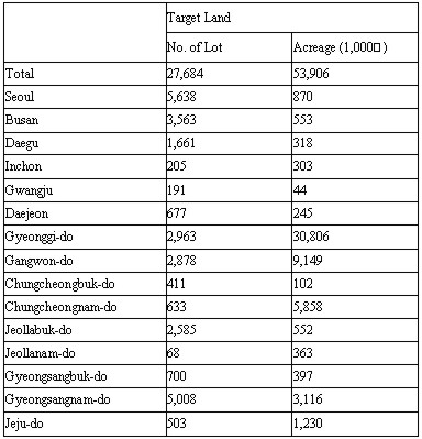
have affected this problem. 2.2.2 Technical Causes Minor error is always expected in the surveying technique. Though the cadastral skeleton surveying, a method connecting around 40 points of graph lines, can accomplish accurate value of the concerned graph line, the accuracy of its value may be deteriorated while connecting with adjacent graph line due to an affected match. In those days, as there were no grounds of restoration on the cadastral law, the surveying had to be done by questions and answers, tact and guidelines without clear institutional support. Furthermore, overall lags such as repetition of creating same drawing, errors on creation and quality of paper could contribute to the problems. The scale of the forestland map should be 1/6000 or more, however, it was most likely to have lots of errors occurring due to insufficient technique while changing the scale in the process of converting the use. 2.2.3 Primitive Technical Manpower The supply of technical manpower had not yet met the demand at the time of intensive need of them by transition of physical status quo of land such as the national development project, disposal in government-vested land from Japanese, adjustment of unauthorized variation of moving zone, distribution of farmland according to the farmland reform and facility compensation system of measurer. The time was not at all or very little productive of technical manpower from the higher educational institutions. Consequently, the supplementary member who were self-trained by the management unit had to involve dealing with those tasks. As the skills were acquired by apprenticeship, the supply-demand of human resources was primitive due to lack of systematic and conversant initiation of skills. 2.2.4 Land use in disorder After the Korean War, jumbling up unauthorized houses by refugees, unauthorized land transformation, construction work without regard for boundaries, voluntary alteration of boundary and illegal bargain with neighbors were observed without arranging the land register as a follow-up measure. Thus, actual boundary was different from that of an official ledger, and it would result in bad performances i.e., optical illusion of surveying boundary. Particularly, as the overlooked land occupancy between neighbors became a hot issue of boundary dispute someday, it resulted not only in being cancerous against local development and the unity of the people, but also becoming a cause of inconsistent land with Cadastral records. 2.3 Actual cases of inconsistent land with Cadastral records2.3.1 Masan This case was for a band-shaped rectangular land abutting on the Kyung-Jeon railroad east to west at full length. It was divided into two areas on a cadastral map as the concerned lot of land stretched over in and out of the land readjustment region. Southern part of the lot was identified as a facility green zone along the railroad side while northern part was completed the land readjustment project. The administrative district of this area was changed from Changwon-kun to Masan-si in 1973. With upward tendency of land values due to administrative change at that time, the recognition of residents who wanted for using available land might have accelerated development. This area was where the city of Masan had built about 20 blocks of popular houses in 1970s as a part of house improvement plan within visible range of railroad side and Saemaul project improving dwelling structure. The actual state of inconsistency in this case included overlapping, blank, irregularity of deviation and location error caused by any mistake on changing registration, connection of boundary between Ri and Dong, arrangement of cadastral skeletons, conversion of slop ways and optical illusion on sectional point presented by the owner. In addition to this, there was inconsistency in relation to the ownership. 2.3.2 Busan The inconsistent land with Cadastral records around Hanwoo apartment located in Sahaku, Busan was found in 1976. In the meantime, despite of many attempts to readjust this area, it was aborted in the face of backlash and noncooperation of some residents. With recent suspension of neighboring road-building program, the residents were complained about impediment to local development. Thus, this area had problems more than inconsistency. In several occasions whenever the official in charge changed, they promised readjustment but transferred to another station without fulfillment of promise. Accordingly, the residents were voicing their discontent loudly. The problem also lied in the residents themselves so they had conflicting interests between the neighbors in connection with boundary dispute. Every surveying attempt resulted in different sizes and different boundaries. The current market value in compensation should be applied to a person for having a reduced size land. On the other hand, the past acquisition cost should be suggested to a person for having an increased size to acquire. Finally, whole residents were successfully reached an agreement. With their cooperation, several surveys were carried out for measuring the state of occupancy and creating the corrected surveying performance drawings, the size variation report, the old and new comparison chart, reports by lot number and application for correction based on the surveying results. The readjustment tasks were concluded by visiting the residents to deal with their own problems individually. 2.3.3 Gunsan Our land registration was established the system for the first time from the land survey project that Chosun Government-General carried out to construct infrastructure of governing colony and plundering tax under the colonial period in 1912. The land registration system in Korea started with land registration for tax, the most primitive, and currently developed to a legal land registration that should provide public trust of land indication, protection of the right to resident's property and accurate information data. However, it led to massive public grievance and resident's inconvenience as well as impediment of local development due to inconsistency of actual land occupancy and boundaries. Therefore, the Administrative Reform Committee adopted it as an improvement task to establish readjustment plan to inconsistent land throughout the country in 1993. Despite the plan had been annually promoted, the actual performance to readjust inconsistency of collective properties did not give us entire satisfaction. In Gunsan, primary cause of inconsistency came from the surveying method. This area employed the special minor triangulation. As the whole quantities of four special minor triangles were missing and error occurred during the basic surveying, the special coordinates converted into ordinary were used. Therefore, it resulted in lack of unity on detail datum. In cadastral detail surveying, some causes for the inconsistency of moving zone were the disposal of government-vested property, the special law for transferring farmland ownership, the compensation system of actual expense without previous notice and the technical error occurred by measurer during the survey on moving zone. After the Korean War, the mixed causes occurred by owners such as unauthorized construction in disregard of actual boundary, reconstruction and extension were observed in the collective resettlement area for the out-of-towners and populaces. In an affirmative surveying, the deepened conflict between the neighbors might invite the boundary dispute by letting the landowners to indicate boundaries of their own occupancy. Also this affirmative surveying were carried out based on an actual state of occupancy in disregard of registered boundaries on the official cadastral ledger so the collection of agreement were not easy from a person having a reduced size land due to tenacity of compensation on land value. In a numerical surveying, despite a calculated size were fixed as an affirmative size, unwillingness of submitting application for ownership due to size variation between affirmative size and that of an official ledger, and the rigid work process of a person in charge were observed. On surveying against boundary dispute, a person in charge often decided an inconsistent land randomly and left the matter unsettled in a negative attitude without verifying, identifying and solving the boundary problems. Furthermore, at the time of dividing the official duties for the readjustment of inconsistent land, they simply took plans with perfunctory procedures rather than solving problems on the spots. 2.3.4 Donghae A case in Donghae, Gangwon-do showed that the last lot of coastal area was located on the precipitous cliff as the Cadastral records were pushed toward the cliff one by one during the basic survey with modern surveying technique in the rule of Japanese imperialism. This inconsistent land with Cadastral records was originated by an elemental error that could not be found with basic surveying method in the field survey. There were no particular problems, for example, exercising possession right or damage of income from use as long as nobody claims its rights from the cliff. National Current Status of Inconsistent Land with
Cadastral Records
3. THE IMPACT ON THE LAND ADMINISTRATIONThe impact of inconsistent land with Cadastral records on the land administration ranges from taxation, effective decision-making and implementing land policy to the social/managerial field. 3.1 Social Aspect3.1.1 Weakening national unity and land market Inaccurate land indication easily can be a cause of land dispute between the neighboring landowners. The restored land on the surface of the earth by determining land size on the basis of the cadastral map always results in a legal issue between the neighboring landowners. The boundary restoration survey can be accepted when it looks advantageous, in turn it may develop to a lawsuit when it is at disadvantage. The inconsistency with actual land results in impediment of exercising land ownership and problems on the transactional order. The duplicated registration can also be a double transaction with other intention. It may become a target of fraudulent practices when it is misused. For these reasons, national unity and land market can be weakened. 3.1.2 Confusion on the rights of entity Since the entity of rights is different due to inconsistency of land boundary, an official cadastral ledger may lose its functionality of public announcement as well as ownership registration of land transfer and settlement of fixed collateral are in much trouble. Thus, the inconsistency of land boundary being basis for recognizing rights of entity will become a significant social issue. 3.2. Administrative aspect3.2.1 Overview The cadastral registration that is a core factor on the rights of entity consists of boundary and size. Inaccurate cadastral registration may not only cause economic damage and enormous inconvenience in exercising land ownership but also incur peoples' distrust. Administration on Cadastral records may also be under threat of collapse by suspension of land transfer. 3.2.2 Impact on taxation and public works Since composite land tax, acquisition tax, capital gains tax and development allotment are levied depending on the registered land on the official cadastral ledger, the resistance may be increased against unfair assessment. It also has significant influence on facilitating public works. Hence, the inaccuracy of Cadastral records can be seen to impact greatly on the administrative aspects of day-to-day administration. 4. READJUSTMENT PLAN FOR THE INCONSISTENT LAND WITH THE CADASTRAL RECORDSThe most ideal readjustment plan for the inconsistent land with the Cadastral records would be explaining the iconographic cadastral registration system in numbers. It could be most desirable to proceed re-survey project as scheduled in order to shift cadastral registration from detail to multi-purpose. In terms of this, I will propose a range of methodology as follows: 4.1 Traditional methodologyIt is necessary to analyze the causes of inconsistency of land register and manage intensively based on the result until completing full readjustment. In the course of converting scale from minor to major, the variation should be processed based on the agreement of interested parties. Organizing the readjustment committee, a proper measure should be adopted autonomously to solve the problems. In correction of boundaries, there is a method to accept minor variation within tolerance. However, this method requires circumspection as it may encourage another inconsistency. 4.2. Introduction of land merger with the public worksIt refers to scaling up the land, which is yet far from achieving while leaving in the land market. Plans that local government or public organization can play a leading role to scale-up the lot by the urban development or renewal projects may be considered. In the process of changing scales, the surveying on the present state of buildings should be executed at the same time to attract residents' attention. 4.3. Election of competent leaderIt is a plan to carry out re-surveying under the present state that the owner actually recognizes its own occupancy. The boundary and size are decided according to the current on-the-spot boundary in disregard of existing records. This methodology is only possible when competent leader who gains absolute trust by local residents is elected. 4.4. Land contribution to the local developmentIt is a plan to be considered in line with election plan of competent leader, which land readjustments are carried out based on the actual boundary. The owner having the reduced land contributes the relevant land to the local development fund. To recognize the spirit of sacrifice and cooperation, the local government erects a monument at the entrance or specific location in the concerned area. Thus, the devotion to its hometown will be handed down to posterity as well as the here and now. For instance, less than 5 Pyong will be regarded as an exception to settle while more than 5 Pyong of the reduced size will be settled as a contribution to the local development. 4.5. Review on launching the public readjustment bodyThe plan to launch the public readjustment body specialized in the matters of inconsistent land separated from the management of land registration throughout the country can be considered. 4.6. Boundary set-up on affirmative surveyingPrior to the investigation surveying, the target land for merger should be suggested merger in advance and boundaries should be fixed on the basis of distinct on-the-spot landform and natural features such as fence and road. When the boundaries are unclear to judge, those that do not affect the size of the land in the official ledger should be identified and then decided as definite boundaries based on the feasibility study and agreement. In setting up boundaries, bypaths should be included in the lot registered on the cadastral map while boundaries of public sites or trunk roads (national land) are fixed at the present state of occupancy. For an individual occupancy of national land, the private lot should be fixed based on the size specified in the official ledger. Excess occupancy should be identified and notified to the related administrative department so as to suggest possessor for acquiring it in future. Hence, boundaries of the lot having a broad range of variation should be adjusted according to the present state of occupancy. 4.7. Determination of sizeUnder Enforcement Ordinance of Cadastral Act Article 48 Section 1, for the result of an affirmative surveying, the size specified in the official ledger should be determined as an affirmative size when the size variation falls within tolerance. On the other hand, allowable size should be dealt out and determined as an affirmative size when the size variation is exceeded tolerance. The affirmative land size should be determined in the way to minimize the variation. 4.8. Organization of readjustment committeeAccording to the operating policy, the readjustment committee designates head of a Tong (the second-lowest city administrative unit) or someone who are familiar with neighborhood among the land owners in the concerned area on the recommendation of Dong (village) headman to create an adjustment atmosphere. They may assist to arbitrate boundary dispute or act as go-between the parties within the target land and encourage the parties to submit a correction of registration data. 4.9. Campaign of publicity to residents for the readjustment planOn the basis of the surveying results, the target area should be decided and the determined boundary, size and target land along with intention to make correction of relevant registration data should be notified to the residents with a notice for requesting support on the readjustment plan. Also a series of campaign of publicity to residents should be stepped up, for instance, holding a steering committee to explain readjustment policy and hear what the residents say. 4.10. Identifying the target land for correction of registrationAfter holding a steering committee and collecting residents' opinions, the target land for correction of registration should be identified in the land register. The would-be corrected land ledger with old/new comparison drawing should be notified. In addition to this, the application of readjustment should be created for allowing the concerned owner to file an application. 4.11. Collecting application of readjustment and readjusting the official ledgerAfter collecting the application of readjustment, the corrected drawing reflecting new registration input should be recreated under the approval of recreating the cadastral map. Boundaries and sizes should also be corrected in the land register. The process will be concluded by notifying the results to the interested parties and sending an acknowledgement to the steering committee. 4.12. Challenge to eliminate the inconsistent land with the Cadastral recordsWhen the land dispute occurs, the measurer often settles the dispute by correcting the registration data as a follow-up measure. What is the most important solution would be to eliminate the cause of occurring the inconsistent land with the Cadastral records by precise surveying in the first place that allows producing accurate surveying results. Administrative methodology to eliminate the inconsistent land is to correct the registration data, change scales and re-survey. However, correcting the registration data would actually be difficult task. Establishing a provision should be reviewed to allow readjusting the size in the official ledger in virtue of its official authority without agreement of owners when the boundary would only be corrected within the tolerance of affirmative size in readjusting the inconsistent land. Avoiding the concept of affirmative surveying that redraws a new cadastral map, the registration data should be corrected based on the registered boundaries of cadastral map to allow becoming a clear evidence for the cadastral administration and exercising the privilege of land ownership. 5. THE INCONSISTENT LAND WITH THE CADASTRAL RECORDS IN APPRAISALIn appraisal, it is a fundamental process that the estimation of the inconsistent land with the Cadastral records should be rejected, being basically considered as physical inconsistency. However, though the land is in inconsistent with the Cadastral records, the possessory rights of the final possessor should be protected at the time of appraisal when the possessor in good faith uses in behavior of occupancy or construction without knowing an elemental cause and such a state of occupancy is being transferred to the next possessor. For instance, though the land in the original Cadastral records locates in a forestland enclosing by dense forest, sea, lake or on the top of precipitous cliff as the case of Donghae, Gangwon-do, there seems no objection raised as long as the current possessor can use the concerned land to realize profit without resistance by third party. For the purpose of an auction or recognizing the degree of inconsistency, the appraisal should be carried out on the basis of the present state of occupancy. However, the degree of advantage/disadvantage of target land compared to other interested parties and opinions of administrative authorities or other interested parties should be indicated as comment in a written statement of appraisal. Also the fact that the land may damage its right of possession or occupancy someday in compliance with title should be clearly specified. 6. CONCLUSIONThere seem no places not having any problem of inconsistency with Cadastral records throughout the country. We have studied causes and actual cases of inconsistent land with Cadastral records, effects of inconsistency impacted on the land administration and the process pattern of inconsistent land in appraisal. To avoid occurrence of additional inconsistent cases in the cadastral management, criteria of assigning boundaries and obligatory provisions should be established together with the need of the organic consensus between the land-related departments. Furthermore, it is necessary to improve legislation that allows including the cadastral registration act in the land-related law. In case of inconsistency between the boundaries of house and road, the sidewalk should be secured by altering the strip of an existing road and the collective grievance should be carried out as a realistic short-term plan. When the position of boundary were recorded incorrectly without causing any variation of lot size registered in the drawing while the application for readjustment had been received from authorities and owners respectively to the target land for correcting boundary and size of the road and old place of residence, the relevant law should be applied to adjust it in virtue of official authority. The relevant procedural and technical regulation should be applied logically to avoid the inconsistent land produced by building a road and prevent the collective grievance in advance. In closing, though the rejection is basically an adequate measure for the appraisal on the inconsistent land with Cadastral records, the conditional appraisal based on the present state of occupancy may be applied according to the purpose of appraisal. If this is the case, the detail should be specified on an appraisal condition or comment so as not to damage any rights of the concerned parties or the third party who trust the written statement of appraisal. REFERENCESAmerican Institute, The Appraisal of Real Estate, 11st edition, AIREA, Chicago, 1999 Chang Gu Yun, Principles of Real Estate Appraisal, pumronsa, 1990 Gil Soung Hong, An introduction of Real Estate Appraisal, Pumronsa, May, 1982 Chang Seok Lee, A Study of Real Estate , Heong Seol Press, Feb 1999 Sang Kyu Kim/Sang Soo Ra/Kyeong Yoong Park, A Study of Real Estate Consulting, Korea Appraisal Board, Oct, 1998 Sang Joon Yoon, Readjustment case of land inconsistent with the cadastral records, KCSC bulletin, June, 2000 Kyeong Hwan Lee, Readjustment case of land inconsistent with the cadastral records, KCSC bulletin, September, 2000 Hong Yeol Moon, Causes and readjustment plan for land inconsistent with the cadastral records, KCSC bulletin, May, 2000 Inspection Report of Korea Appraisal Board annual reports, Korea Appraisal Board, 1988 CONTACTSang-Kyu, Kim 1 May 2001 This page is maintained by the FIG Office. Last revised on 15-03-16. |