GUIDELINES FOR GPS SURVEYING IN AUSTRALIAMatthew B HIGGINS, AustraliaKey words: GPS, Guidelines, Standards, Surveying. ABSTRACTThe use of the Global Positioning System (GPS) continues to revolutionise surveying. With such a rapidly developing technology, many practising surveyors seek guidance to help them correctly perform GPS Surveying. Two issues relating to GPS Surveying in Australia are of relevance to this workshop and will be outlined in this paper. The first issue is Australia's Standards and Practices for Control Surveys. The Standards part of the document establish a way for specifying and reporting the quality of surveys while the second part outlines Recommended Practices for achieving the standards. The second issue of relevance is the process being developed to ensure Legal Traceability of GPS Measurements. Australia has a National Measurement Act, the purpose of which is to define legal units of measurement and provide a uniform system of weights and measures throughout Australia. Processes are currently being developed to allow GPS Surveying measurements to be traceable to the relevant standard and thus conform with the Act. 1. INTRODUCTIONAustralia is a federation of States and has a National (or Commonwealth) Government as well as a second level of Governments for each of its States and Territories. Surveying and Mapping in Australia is a shared responsibility between those levels of government. The need for a high level of cooperation between the various agencies involved has been recognised since the 1950s. The Inter-Governmental Committee on Surveying and Mapping (ICSM) has the responsibility of ensuring such cooperation occurs. ICSM has member agencies from the Governments of the Commonwealth and of all States and Territories of Australia. The New Zealand Government is also represented. The ICSM also has a number of Technical Sub-Committees to address specific issues or subject areas. Issues related to GPS are often referred to the Geodesy Technical Sub-Committee (GTSC). Two activities of the ICSM GTSC relating to GPS Surveying are of relevance to this workshop and will be outlined in this paper:
2. STANDARDS AND PRACTICES FOR GPS SURVEYSOne important function of ICSM is to develop and maintain standards and practices for surveying and mapping activities. A widely used ICSM publication is the Standards and Practices for Control Surveys (referred to as SP1). It should be noted that SP1 is not currently an official Australian Standard. ICSM has made initial investigations into SP1 becoming an Australian Standard. However, there is a requirement for mutual recognition, where possible, between Australian and New Zealand Standards. The New Zealand member of ICSM has its own equivalent of SP1 and while many of the underlying concepts in the two documents are similar, it has been decided, for now, to continue with two documents. In any case, both are well recognised and are effectively the de-facto standards in their areas of jurisdiction. In Australia, SP1 covers many technologies. The importance of GPS Surveying has been recognised since it came into general use in the 1980s and SP1 has reflected that importance. SP1 continues to be upgraded as new developments occur. For example, the latest version includes several amendments to cover the Real Time Kinematic GPS Surveying technique (RTK). SP1 is divided into two parts. Part A sets Standards and Part B contains Recommended Practices for achieving those Standards. To quote the document: The purposes for which Parts A and B have been prepared are quite separate and distinct, as explained below. PART A:
PART B
(from ICSM, 2000) The Standards in Part A define the concept of Class and Order and these allow the quality of surveys to be assessed and quoted. The standards of CLASS and ORDER are explicitly defined as follows:
(from ICSM, 2000) As well as these definitions, Part A sets out how to calculate and assess the quality measures involved. Part B of SP1 contains Recommended Practices for achieving particular levels of Class and Order. The Recommended Practices cover field techniques as well as the processing, adjustment and analysis of results. The Recommended Practices are grouped according to technique as follows: Astronomical Azimuth Determination,
The Section on GPS is the most detailed in Part B and includes the following headings:
Previously, the use of Class and Order in SP1 has concentrated on analysis using least squares adjustment. One of the major attractions of RTK is that there is no need for post-processing of the GPS data. Consequently, it is also desirable to be able to assess the quality without the need for least squares adjustment. Given this, the latest version of SP1 introduces a process for analysing the quality of RTK surveys using comparisons of the misclosure between multiple occupations of the stations in the survey.
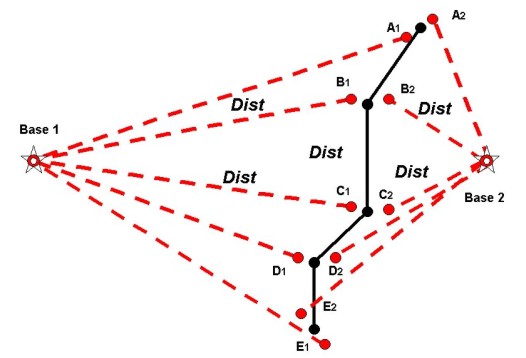
Figure 1 An RTK Survey and Its Analysis The use of misclosure analysis is best explained using an example. A possible RTK survey is shown in Figure 1 (taken from ICSM, 2000). Suppose a client requires new stations (A to E) to be coordinated along a road corridor and states the relative accuracy required between the new stations. New stations would typically be occupied using a base station at Base 1 and then reoccupied using Base 2, according to recommended practices elsewhere in SP1. For example, for the new station B, the occupation using Base 1 produces a set of coordinates for B at B1 and the occupation using Base 2 produces a set of coordinates at B2. The misclosure methodology in SP1 gives guidance on calculating the expected misclosure between occupations (eg between B1 and B2) based on the manufacturers specifications. That can be compared to the misclose between the actually observed occupations to enable the quality of the measurements to be assessed. Once a surveyor has shown that the GPS measurements are conforming to manufacturers specifications, SP1 also gives a methodology to calculate an estimate of the relative accuracy between new stations (eg between B and C). This is necessary when using base stations because there may not be direct measurements between the new stations. There are many aspects of SP1 that could be discussed in a workshop such as this. However, the way the latest version of SP1 covers the RTK technique is a good example of how changes in technology can lead to a need to change the approach used in guidelines if they are to remain relevant to practicing surveyors. 3. LEGAL TRACEABILITY OF GPS MEASUREMENTSIn 1948 the Commonwealth Parliament enacted the first national legislation defining legal units of measurement in Australia. The current version of the legislation is the National Measurement Act (1960). The legislation provides a uniform system of weights and measures throughout Australia. Measuring instruments can be certified through processes set up under the Act. Such certification provides a level of confidence that the instruments are fit for purpose and that any measurements using those instruments have been made on a nationally consistent basis and are traceable to the Australian standards of measurement. The objects of the Act are:
The Act requires that where Australian legal units of measurement have been defined for a physical quantity, then measurements of that physical quantity shall only be legal when they are traceable to the Australian primary standards of measurement. This traceability typically involves reference to, comparison with, or derivation from an Australian (national) primary or secondary standard or a State primary standard. There is also provision for traceability via a recognised-value standard of measurement. The National Standards Commission administers the Act with the assistance of agencies from the various States and Territories of Australia. One of the methods for disseminating standard of measurement is by the National Standards Commission appointing Verifying Authorities for a particular physical quantity. The information above is based on National Standards Commission (1995); direct quotes are in italics. For surveying, many ICSM member organisations are also Verifying Authorities for length in their State or Territory and have established processes to ensure the legal traceability of measurements. For example, in the case of Electronic Distance Measuring Equipment (EDME), Verifying Authorities establish and maintain calibration baselines and provide the associated services for computation and analysis. It is against this background that the issue of Legal Traceability of GPS Measurements has arisen. The issue is whether a survey relying on GPS measurements and used as evidence in a court of law could be questioned due to a lack of traceability to the relevant standard. A typical example of interest to ICSM members would be a cadastral surveys using GPS. Given this, the Geodesy Technical Sub-Committee of ICSM has been working with the National Standards Commission to develop a process enabling GPS measurements to attain legal traceability. One of the first questions to arise was whether GPS measurements are in terms of position or length. On one hand the measurements between the GPS satellites and the user's antennae can be seen as length measurements. On the other hand, the measurements have no meaning without the positions of the satellites and, for GPS Surveying, the position of a known station. It should be noted that there continues to be discussion about this length vs position issue. This was also an issue in the context of legal metrology because length was already recognised as a physical quantity while position was not. After significant discussion and analysis it was decided that position could be defined as physical quantity under the Act and that for GPS Surveying a process to enable traceability of position should be developed. It should be noted that discussions to date have concentrated on GPS Surveying, rather than other GPS techniques such as point positioning as used in navigation. It must be remembered that the National Measurement Act is about ensuring "that measurements are what they purport to be" (Dedman quoted in National Standards Commission, 1995). The question then is; what are the problems with GPS Surveying that could make measurements not be what they purport to be? At first, the approach used with EDME seemed to be a useful approach for GPS. With EDME, the major issues are instrumental offsets and cyclic error and those are the primary targets for EDME traceability processes. On the surface, GPS Surveying appears to give a result similar to EDME in that the final result is a baseline between two points. However, it is important to remember that the measurements are actually made to the GPS satellites. The difference in position between two stations (the GPS baseline) is derived from two independent sets of measurements of the phase of the carrier signal broadcast by the satellites. Specifically, GPS Surveying is based on the so-called double difference carrier phase observable. The approach means that systematic errors arising in the phase measurements internal to the instrument are differenced away and there is no calibration problem comparable to that with EDME. Given the heavy reliance on atomic clocks throughout the control and space segments of GPS, it could be argued that so long as the processing algorithms use the correct values for the nominal frequencies and speed of light, there is little chance of scale error in GPS Surveying. Errors in the final GPS baseline are less likely to be due to instrumental and calibration issues and more likely to be due to site dependent errors such as multi-path or incorrectly modelled atmospheric errors or gross errors such as software incorrectly resolving the so-called phase ambiguity. Ensuring that GPS Surveying measurements are what they purport to be is therefore as much about best practice as it is about traceability. Having said that, the legal metrology issues require that if position is a physical quantity then it is necessary to have a standard for position to which GPS Surveying measurements could be traceable. The method being developed in Australia to allow traceability involves a hierarchy of several steps. The first step has been to recognise the Australian Fiducial Network (AFN) as a recognised-value standard of measurement for position. The AFN is a network of permanently tracking GPS receivers established by the Australian Surveying and Land Information Group (AUSLIG). The AFN serves two purposes. Firstly, its permanently tracking receivers enable the overall quality of the GPS to be monitored while GPS surveys are carried out from day to day. Secondly, the AFN is linked to the underlying geodetic network. The next step for traceability will be through Regulation 13 of the Act, which enables a Verifying Authority to certify suitable stations in the geodetic network. Any such stations would need to be linked to the AFN through a least squares adjustment capable of demonstrating the quality of the resulting positions. Such an adjustment process is already largely in place and is the foundation for the new Geocentric Datum of Australia (GDA). The AFN is the mechanism by which the GDA is connected to the International Terrestrial Reference Frame (ITRF) and the adjustments of geodetic networks under the AFN propagate GDA at a suitable density across the nation. In Queensland, for example, the author's Department plans to certify its GPS Networks ranging in density from 100 kilometres in remote areas to a few kilometres in urban areas. All stations in those networks can be traced back to the AFN through least squares adjustments. The formalisation of this step is not yet complete and is awaiting publication of the Verifying Authority Handbook by the National Standards Commission. The final step will be for GPS Surveys requiring legal traceability to connect to certified stations in the geodetic network. In this manner, traceability can be built into every survey and can actually be superior to the current processes with EDME or steel bands, where the instrument is only compared to the standard periodically, such as once each year. It should be noted that as well as connecting to stations somewhere in the hierarchy of geodetic networks, it is possible to include AFN data in the processing of a GPS Survey and connect directly to the recognised-value standard. Such an approach has been facilitated by AUSLIG's establishment of an on-line processing service. Achieving traceability in this direct manner may be viable in certain cases, such as surveys in remote areas of Australia where the extra GPS observation time required for on-line processing is still more efficient than travelling to stations in the local geodetic network. No matter how the connection to the standard is performed, as was suggested earlier, best practice guidelines will play an important role in ensuring the GPS Survey measurements are what they purport to be. That role for best practice guidelines applies to the connection to the standard and to the GPS Survey itself. This final step in the traceability hierarchy will not be in place until the mechanism for Verifying Authorities to certify geodetic networks is established. However, it should be possible to align the best practices for traceability with those already in SP1 (as outlined earlier in this paper). Using this approach, all GPS Surveys will be able to use SP1 as a guide and for those surveys that may have legal implications any extra requirements to achieve traceability should be minimal. CONCLUSIONThis paper has outlined two issues relevant to the establishment and maintenance of Guidelines for GPS Surveying in Australia. The ICSM publication, Standards and Practices for Control Surveys establishes standards for specifying and reporting the quality of surveys and offers recommended practices for achieving those standards. Recent amendments to SP1 to give guidance to surveyors using the Real Time Kinematic GPS technique demonstrate the need for guidelines to be readily adaptable to developments in technology if they are to remain relevant to practicing surveyors. The paper also described the process being developed to ensure Legal Traceability of GPS Measurements in Australia. The process involves a hierarchy of steps designed to allow GPS surveys to be traceable to the recently recognised-value standard for position. This will clear the way for surveys relying on GPS measurements and used as evidence in a court of law, such as in cadastral surveys, to have traceability to the standard in accordance with Australia's National Measurement Act. REFERENCESICSM, 2000, Standards and Practices for Control Surveys (SP1),
Inter-Governmental Committee on Surveying and Mapping, ICSM
Publication No 1, Nov 2000. National Standards Commission, 1995, The National Measurement Act,
Leaflet Number 25, National Standards Commission, March 1995. BIOGRAPHICAL INFORMATIONMatt Higgins is a Senior Surveyor with the Department of Natural Resources and Mines, Queensland, Australia. He received Bachelor and Masters degrees in Surveying in 1983 and 1988, respectively. He is presently undertaking a PhD at the University of New South Wales working in GPS Heighting. Matt is Vice Chair of FIG Commission 5 on Positioning and Measurement for the period 1998 to 2002. He is on the Editorial Advisory Board of GPS World Magazine. Matt is also a member of the Geodesy Sub-Committees of both the Australian Academy of Sciences and the Inter-Governmental Committee on Surveying and Mapping for Australia and New Zealand. CONTACTMatt Higgins 21 April 2001 This page is maintained by the FIG Office. Last revised on 15-03-16. |