Working Group - Joint Commission 3 and 8
GIS Tools for Spatial Planning
Policy Issues
GIS tools hold great potential to support spatial planning practice.
Ongoing developments in digitalization of data sets and communities
further open up possibilities to apply GIS tools in spatial planning
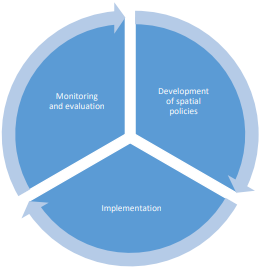
processes. The latter typically follow a cyclic pattern: (1) development
of spatial policies, (2) policy implementation, and (3) monitoring and
evaluation. Spatial policies range from strategic visions to land use
plans that at operational level determine and distribute land use types.
Together with legislation and rules, these spatial policies constitute
the framework for implementation of spatial policies. Programmes,
projects, enforcement mechanisms and the like can be used to implement
spatial policies, depending on the situational context. Finally,
monitoring and evaluation is necessary to measure whether policy aims
are met or need to be adapted, which may lead to the development of new
spatial policies.
Figure: Spatial planning cycle
Due to the different nature of each phase in the cycle, GIS tools to
support spatial planning practice will require different data
specifications, functionality and usability features. This working group
aims to gain a better understanding of developing useful GIS tools given
a particular planning exercise, based on the different phases in the
spatial planning cycle. Having appropriate and user friendly GIS tools
available will create a positive spin-off in terms of enhancing
information transparency and increase inclusiveness among participating
stakeholders.
Examine current GIS tools used in spatial planning practice and
consider the potential role for future applications.
Develop guidelines based on best practices regarding data
standards, functionality and usability of GIS tools.
Encourage the use of spatial information and public
participation in spatial planning by using e-government.
Foster transparency, inclusiveness and legal certainty in
decision-making by providing tools for stakeholders to access
information and participate in spatial planning processes.
What we are working on -
Website or other interactive digital platform to provide
the results of the GIS tools analysis.
FIG publication: GIS tools for spatial planning – Best
practices and guidelines.
What's New
Focus: Available GIS tools for spatial planning, in particular
participative processes, to encourage transparent, participatory, and
inclusive decision-making.
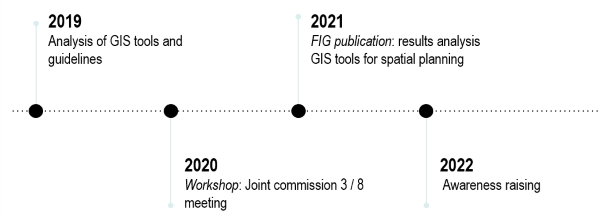
The first draft of its study ‘GIS tools for participatory planning,
an exploratory study on internationally available tools’ was published
in 2019 as a result of the work carried out by working group 8.2. This
will be followed up in 2020 by the respective working group. Focus will
lie on a more in-depth analysis of various promising tools that can be
used in a participatory context.