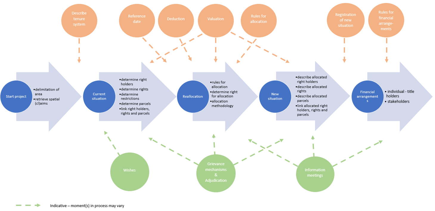
Highlighting spatial planning and development at FIG2020 – Contributions to the Working Week from FIG commission 8FIG Commission 8: Spatial Planning and DevelopmentMarije Louwsma, Claire Buxton, Richard Pagett & Uchendu Eugene Chigbu IntroductionSpatial planning – the focus of commission 8 – is logically much related to the subtheme ‘integrated land and water management’ of the FIG Working Week 2020. From a planners’ perspective it is key to optimize the spatial allocation of various land use types. This applies to both land-based and water-based functions and activities. As such, spatial planning aims to balance the interests of various policy domains and stakeholders in pursue of an overall sustainable development. As land and water are a limited and often scarce resource, those interests may clash, and sometimes hard decisions have to be made. Based on the submitted contributions to the FIG Working Weeks over the last couple of years, we notice that geo-information and its applications in spatial planning gains more and more attention. This entails all aspects from geo-data acquisition, mapping land cover and land use, techniques for spatial analysis, to applications for participatory approaches in planning. Using geo-information is key to make spatially informed decisions about a sustainable spatial development. At the interplay of both disciplines, we discuss what geo-information has to offer to spatial planning and vice versa, together with well-established topics in the realm of spatial planning. The scheduled technical sessions at the Working Week function as a guideline to highlight latest developments in the profession and discuss topics from various angles. Spatial planning at the interplay of geo-information and sustainable developmentDue to the comprehensive nature of spatial planning, some topics are taken up jointly by multiple commissions. Two inspirational short sessions (TS01E: Mapping, Planning, Development and SDI I and TS02E: Mapping, Planning, Development and SDI II), jointly organized with commission 3, highlight the interplay between spatial planning, geo-information and its applications. Contributions range from data acquisition by employing remote sensing techniques to mapping spatial information and analyzing spatial patterns. Besides these inspirational contributions, several use case applications were to be presented in two regular session (TS03E: Geospatial Technology for Spatial Planning and TS04I: Where Spatial Planning and Geo-Information Meet). The diversity of experiences is high, ranging geographically from the global south to the north. It appears from the contributions that having a strategy to collect, store, connect and retrieve spatial data in a structured and coherent way, opens up the great potential that GIS tools hold to support planning practice. This is the case for geo-spatial analyses for policy development, geo-spatial application to facilitate implementation and for monitoring and evaluation. For example, mapping deforestation, 3D spatial planning in urban areas, geospatial multicriteria analysis to assess flood risks, or integrating legal rules into a geo-information portal for spatial planning, are addressed. Also, sustainability plays an important role in the discussion about spatial development. In session TS06I: Environmental Issues & Sustainable Development in Spatial Planning various issues are addressed, such as optimizing the allocation of different land use types, prevent emerging environmental hazards, proper waste management, the effect of urbanization on greenery, and early detection of deforestation. A comprehensive perspective on the implementation of spatial plansDeveloping spatial plans describing the direction of future developments and choices made in that regard, is a great means to guide the spatial development. Next step is to employ policy instruments to actively facilitate these developments and effectuate changes in the field. In TS03I: Land Consolidation: from Plan to Implementation papers about various applications of land consolidation in different international contexts will be presented. The potential that land consolidation holds for a holistic approach for optimizing the land use, as well as for climate adaptation and carbon dioxide reduction, is highlighted. Whereas traditionally agriculture used to be a key driver for land consolidation, nowadays in view of the sustainable development goals, environmental and social aspects are emphasized and valued too. To secure land rights for involved stakeholders in land consolidation projects, proper land consolidation software systems are much needed. Since currently no standardized system is available on the market, most countries employing land consolidation have developed their own customized digital system. One of the activities of commission 8 is to explore the possibility to develop a generic system (Figure 1) that can be adjusted to the different legal frameworks, aims, tenure systems and traditions in place. The underpinning concept of such a generic tool for land consolidation, by explaining how it should work, how it can be adapted to the various use contexts, and how to adapt its functionality is addressed in this session as well.
Regarding urban planning, session TS08I: Integrating GIS Tools and Citizen Perspectives in Planning for Metropolitan Areas exemplifies how various citizen-science and technical tools and techniques are applied to retrieve, assemble or integrate information in planning processes. Here again, a holistic approach is key to foster sustainable development and use the scarce space in a multifunctional way and think of designing compact cities. Searching for ways to efficiently combine various land use functions or optimize compact cities shed a new perspective on sustainability in urban planning and the role of citizens. Urban Challenges: Creating Sustainable Community with DensityWhile all cultures and settings are different, we
have highlighted some common, vital tools for
combating
urban challenges in this special session. A
sociotechnical approach to rapid urbanization can
help close the gap between rich and poor and take us
all toward SDG 11 (inclusive, safe, resilient and
sustainable human settlements). Innovative ownership solutions are trialed and have succeeded in enabling social cohesion. Community Land Trusts, Mixed Tenure, and Unit Titles, when implemented well, increase stewardship in a community as well as enabling affordable housing. Community Land Trusts take the land value out of a house price so that low to middle-income families can benefit from secure land tenure. These ownership options help encourage diversity and can prevent gentrification of previously affordable neighborhoods. Identifying issues from the perspective of residents and through spatial analysis are part of the solution to urban challenges. Spatial planning enables informed decision-making on issues resulting from rapid urbanization. Left uncontrolled, densification can suppress a city from becoming socially cohesive and prevent creation of a place of safety and identity for its people, which was the original purpose of a city. Good practice for resilience planning in water governanceResilience applies to both the industrialized and
less-industrialized parts of the world and is
associated with many aspects of human activity,
often responding to the effects of climate change.
It could be related to food, water, land, or energy
scarcities. It could relate to living by the coast
and the threat of sea-level rise and storm surges,
or in mountainous areas threatened by glacial
deluge, or in arid areas with erratic rainfall, or
on small or low-lying islands facing increasingly
violent storms. Whenever and wherever there is a
threat of a natural hazard (such as flooding,
drought, heatwave), then there is an associated need
to “come back” after the effects of that hazard have
been endured. Development gains can be quickly wiped
out by a natural hazard directly, a surge in prices,
or a resource conflict. Gains could also be
undermined over time by the cumulative effects of
stressors such as climate change, environmental
degradation, water, food, and energy scarcity, and
economic uncertainty. While humanitarian responses
to crises have saved lives and helped to restore
livelihoods, such efforts have not always addressed
underlying vulnerabilities. Some current thinking on the following policy issues has been developed:
We are currently working up possible future scenario strategies for managing water resources in order to provide guidance to governments, municipalities, communities, and professionals. The final deliverable will be a developed and described generic process for the building of resilience into urban water governance particularly from the perspective of the role of surveyors. The development of a conceptual framework for urban-rural linkagesAbout 80% of all the global rural population live close to either urban regions or cities. This spatial proximity scenario presents an opportunity to link rural and urban areas – a move that is highly mandatory for achieving the sustainable development goals (SDGs), especially the SDG that is related to achieving sustainable cities and communities (SDG number 11). The current Covid-19 pandemic also shows that rural and urban areas need to coexist for mutual benefits. Many city dwellers in the developing countries are seeking refuge in the rural areas where they are closer to their relatives and have the needed space necessary for social distancing. On the other hand, people in rural areas are relying on essential goods (such as face masks mostly bought or produced in cities) to enable them to protect themselves from the Coronavirus. This is only one immediate example of why rural and urban areas need to cooperate or collaborate in their quest to achieve everyday development goals. Ongoing development efforts would not lead to a balanced outcome, at least from a spatial sense, unless the disparities that exist between rural and urban areas are curbed. This is why the potential linkages (including demographic, knowledge exchange, labor, infrastructure, public services, environment and cultural aspects) that rural and urban areas share, must be leveraged to produce balanced development outcomes. However, this would not be possible without tapping into the role land plays in the development process. In order to ensure adequate balance in the development of rural and urban areas, both need to be viewed as spatial partners that can enable the development of one another, rather than as separately competing entities. This approach is necessary to tackle the challenges both rural and urban areas face, in a matter that is beneficial to both units. Hence, the conceptual framework being prepared by the FIG-Commissions 7 & 8 (through its Professional Cluster) for application by the GLTN will contribute to the global discourse on how best to develop rural and urban areas in an inclusive, interdependent way. A special lunch meeting had been scheduled during the FIG Working Week in Amsterdam to discuss this topic among all involved stakeholders. As the FIG Working Week was cancelled due to the Coronavirus pandemic, concerted efforts are being put to ensure that the discourse continues as a global concern. It is hoped that the discourse would not only lead to the development of a conceptual framework. It is expected that the discourse would lead to the development of a specialized land tool on rural urban linkages by the GLTN and its partners (including the FIG). Upcoming activitiesTogether with FAO, two sessions about land consolidation were scheduled: TS01I: Land Consolidation Legislation: FAO Legal Guide and its Application at the Country Level and TS02I: The Role of Land Consolidation and Other Land Management Instruments in Development of Agricultural Land Markets. The first presents the new Legal Guide on Land Consolidation prepared based the outcomes of a study on good European practices for land consolidation legislation. The second focuses on the role of land consolidation and other land management instruments in developing agricultural land markets in the ECA region as well as to support the application and implementation of the Voluntary Guidelines on the Responsible Governance of Tenure (VGGT). The main constraints hampering development of agricultural land markets and the interconnection between land markets and land management instruments are highlighted. Both joint FAO - commission 8 sessions will be covered in a webinar for which we will set the date soon. So, keep an eye on the respective websites from FAO and FIG and follow their newsletters to register for the webinar, or have a look already at the papers that were submitted. Apart from the technical sessions and regular activities, commission 8 had scheduled a side-event about land and water management in the Netherlands (Figure 2). Jointly organized with our partners in the Netherlands, this is a unique possibility to peek behind the scenes of various organizations and professionals working in the field. From the start of registration, it proved to be a very popular event. Therefore, we are happy to announce that we will have this event scheduled for the FIG Working Week in 2021 as well. On behalf of commission 8, we kindly invite you to join the Working Week in the Netherlands next year and enjoy the organized activities – from technical sessions, social events to the tours.
|
|||||
 |
Marije Louwsma, |
 |
Claire Buxton, Co-Chair, Working Group 8.3, Urban Challenges |
||
 |
Richard Pagett, |
 |
Uchendu Eugene Chigbu, |
||
|
References Further readings:FIG Working
Week 2020 Proceedings FIG Commission 8 Sessions:
FIG Commission 8 website:
|
|||||
 #FIG2020 /font> |