News in 2014

|
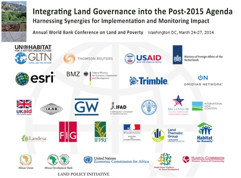
Integrating Land Governance into
the post-2015 Agenda - The Annual World Banks Conference on Land and Poverty
24-27 March 2014, Washington DC, USA
The Annual World Bank Conference on Land and Poverty brings together
representatives from governments, civil society, academia, the private
sector and the development community to discuss issues of concern to
practitioners and policymakers worldwide. The conference aims to foster
dialogue and sharing of good practices by showcasing the diversity of
reforms, approaches and experiences that are being implemented in the land
sector around the world.
The Bank and FIG has had strong formal partnership since 2007. Over the
past two years (2012 and 2013) FIG and the Bank have jointly organized
successful spatial tracks for this annual Conference:
- 2012 – day long forum comprised of parallel sessions to the main
conference followed by an evening round-table, with the focus on
Spatially Enabling Government and Societies (SEGS).
- 2013 – nine specifically designated spatial parallel sessions and a
post-conference “invitation only” Expert Group Meeting on the theme
“Spatially Fit-for-Purpose”.
It should also be noted that the Bank and FIG at the 2010 WB Conference
conducted a special parallel spatial session (panel discussion) with the
theme “Moving Towards ‘Land Information 2025’: Next Steps”. This session
debated on “post Cadastre 2014” and initially raised the notion of
“fit-for-purpose” investment in land administration systems.
Within International Federation of Surveyors (FIG), we continue to
recognize that Land (and the seas, the natural resources and the structures
thereon) remains capable of generating opportunities for the betterment and
wellbeing of all. However Land is also finite and our Profession’s sciences
and technologies are more than just means and tools, and must extend the
utility and usefulness of that sciences, technologies, knowledge and
practices, the measurement and mapping, the models and management, towards
the betterment of society, environment and economy.
The 2014 Land and Poverty Conference was attended by over 1,200
participants with a program that spread, for the first time, over four days
and FIG and the Bank jointly and successfully organized a day-long Forum on
“Spatial Innovation and Good Practices” on the fifth day. This year’s
Conference had an overall focus on the Post-2015 UN Development Agenda and
the theme is ‘Integrating Land Governance into the Post-2015 Agenda:
Harnessing Synergies for Implementation and Monitoring Impact.” The 2014
conference focused on building a shared understanding of best practices in
land governance by providing opportunities to strengthen collaboration
between diverse experts. The Conference had seven thematic areas:
- Securing and protecting land rights from a gender perspective
- Managing urban landscapes
- Attracting responsible land-based investment for local benefits and
common resource management
- Maximizing benefits from spatial data
- Strengthening country level institutions
- Fostering transparency in land ownership, use, and administration
- Research on key aspects of land governance
The one-day long Forum, immediately after the 2014 Land and Poverty
Conference (March 24 - 27) on 28th March 2014 within the Bank’s premises in
Washington DC was open to all registered participants to the Conference.
Prior notification of attendance was requested and over 130 responded. The
Forum covered a number of themes focusing on the contribution of spatial
technologies and practices to support the Post-2015 Development Agenda.
These themes include data collection, data management, data access, data and
information sharing, analysis and analytics, visualization and presentation
and delivery systems and services particularly when considering the
challenge in locating, connecting and delivering information with both
geographic and temporal context from differing scales and sources to
governments and societies.
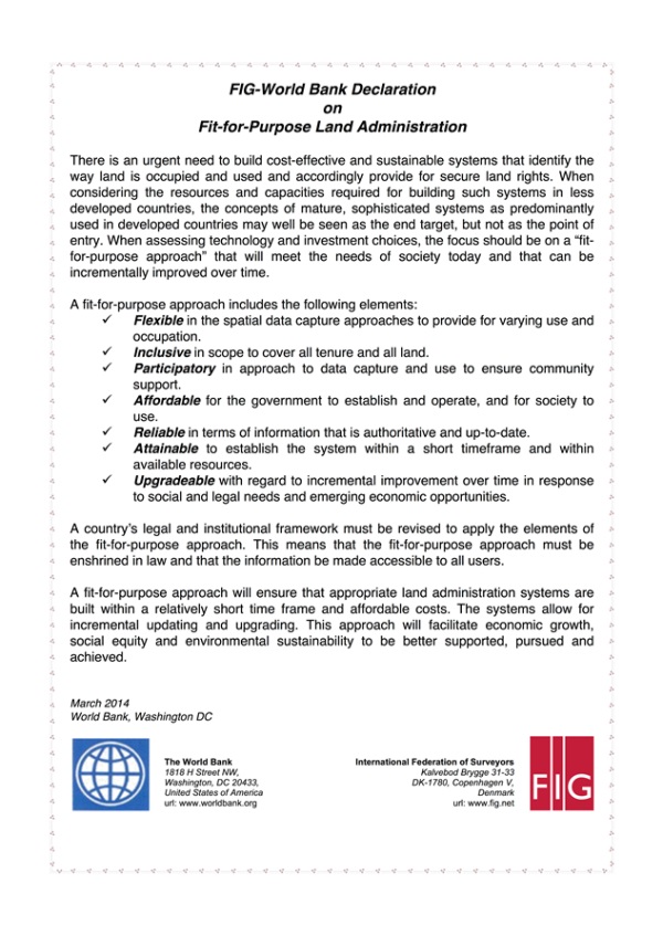
The Forum witnessed the launch of the joint World Bank and FIG
Declaration on Fit-for-Purpose Land Administration providing the framework
on getting the right data and information, the right processes and
technologies, all for the right purposes. This Declaration is part of the
Joint FIG and World Bank Publication on Fit-for-Purpose Land Administration
(FIG Publication Number 60) with Prof. Stig Enemark as the lead
author and Dr. Keith C Bell (WB), Dr. Christiaan Lemmen and Robin McLaren as his co-authors. (FIG
and World Bank Declaration)
At earlier annual World Bank Conferences on Land and Poverty, concerns
have been raised from various stakeholders that the procedures and
requirements, particularly for surveys, mapping and accuracies in land
administration projects were often too cumbersome and expensive and do not
necessarily deliver that which is needed by citizens for achieving security
of tenure. There were also the issue of operations and maintenance, the
overall sustainability of system that was put into place, many an instance
challenged to improve services delivery and access to land information.
These issues have been debated over the past three years at several
sessions, seminars and workshops jointly convened by the Bank and FIG at the
annual World Bank conferences on Land and Poverty.
Emerging from these joint events is the concept of “fit-for-purpose”
indicating that land administration should be designed to meet the needs of
people and their relationship to land in support of security of tenure for
all, the sustainable management and use of land and natural resources. This
perspective calls for a flexible approach rather than rigid demands that may
be unsustainable for jurisdictions dependent on donor funding. Such
flexibility allows for land administration systems to be incrementally
improved over time should it be found necessary. As such the Declaration and
the accompanying joint publication presented such a flexible approach. (The
link to the publication:
https://www.fig.net/pub/figpub/pub60/figpub60.htm)
FIG/World Bank Spatial Innovation and Good Practices in Land
Administration Forum, 28th March 2014, Washington DC
The Forum heard of current and future spatial technological envelope that
is co-evolving with other technologies particularly that of mobile computing
and communication, enabling and empowering citizens and communities and
providing unparalleled possibilities. The Forum heard of good concepts
(fit-for-purpose, easy-to-use, leapfrogging), great ideas (global campaign
for secure tenure, massive global and spatially enabled
private-public-partnerships) and of boldness to borrow from or linking up
with playbooks from global public health initiatives, from global media and
entertainment reach, from multi-national business, and learning from social
phenomena inspired by the likes of Google and Facebook. Changing the
paradigm to finally deliver the desired difference.
The one-day Forum observed a move beyond land administration to pervasive
spatial integration of society. The partners and participants at the Forum
are at the forefront, channelling these developments for progressive global
change. Country level experiences shared at the Forum affirmed this good
news, as there are good progresses.
At the same time, the Forum recognized the challenge of the “two-speed”
world we are in, where in one world, a technology savvy kid can use the
marvels of global navigation satellite systems and mobile computing and
communication to find the best cup of coffee and in another world, 80% of
humanity live below US$10.00 a day or where 75% of humanity do not have
clear spatially and legally defined land or property rights and where
communities have inadequate access to this global normalized digital maps.
We have to accept that there exist this disconnect between spatial
technological sophistication that is available today and the outcomes of
decades of development initiatives and programs.
The Forum concluded that the barriers to closing this gap are no longer
technological, spatial technologies and practices are today pervasive,
affordable and accessible, but rather of capacity, institutions and
politics. It is now overdue to bring these worlds together. The partners and
participants at the Forum have yet to make significant stride in political,
institutional and capacity development at scale. This is the bad news!
Is it possible to change the paradigm where the “spatial” is fully
integrated into human development and progress to realize “the Future We
Want for All”, the world of Post-2015 UN Development Agenda?
CheeHai Teo (FIG)
Malcolm Childress & Keith C Bell (WB)
FIG-World Bank Declaration on
Fit-for-Purpose Land Administration . pdf
28 April 2014
|


