Article of the Month -
February 2006
|
Ghana’s Land Administration Project (LAP) and Land
Information Systems (LIS) Implementation: The Issues
Dr. Isaac Bonsu KARIKARI, Ghana
 This article in .pdf-format
1)
This article has been prepared for the 5th FIG Regional Conference -
Promoting Land Administration and Good Governance to be held in Accra,
Ghana, March 8-11, 2006.
Key words: Land administration; Ghana; LAP’s Institutional Reform
Proposals; GIS/LIS project implementation.
1. INTRODUCTION
There are six land sector agencies involved in Ghana’s land
administration project (Figure 1). These agencies have technically been
operating manually in an environment beset with conflicting and unreliable
dada, dubious manipulations of existing data by some recalcitrant staff and
tedious retrieval of available information, suggesting the need to establish
or develop computer-based land information systems and networks through
re-engineering processes and pushing for attitudinal change. It is not the
manual systems per se that are the cause of the problems (although they have
contributed significantly); it is the fact that there are costs, delays and
uncertainties as well as rent seeking behaviours in the system. Generally,
details of flow-lines of information are seldom documented or monitored.
Based on better management of information, substantial improvement within
the lands sector can be brought about by analysing and costing existing
procedures, abandoning unnecessary practices and making better use of
existing resources through the introduction of Information Technology (IT)
and LIS (UNCHS (HABITAT), 1990). Essentially, most organisations would be
keen to know how LIS could fit into their overall IT strategies.
‘Land Administration’ as the process whereby land and information about
land may be effectively managed, indicating that land administration
includes the provision of information on land, identifying those people who
have interest in real estate and information about those interests such as
the nature and duration of rights in land. It also includes information
about the land parcel such as their location, size, improvements, ownership
and value. As distinct from ‘land administration’, ‘land management’ is the
process of managing the use and development of land resources in a
sustainable way. Concerned here is with ‘land administration’, even though a
‘cadastre’ could actually be a land management tool and is normally a
parcel-based land information system containing records of interest in land
(for example rights, restrictions and responsibilities associated with such
land). The UN Commission notes that effective and sustainable land
management is impossible without a cadastre or LIS.
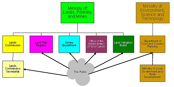
Features:
Six independent agencies, three ministries*:
* Five under the Ministry of Lands, Forestry and Mines;
Ministry of Environment supervises Town and Country Planning at
National/Policy level, Ministry of Local Government at Local/Implementation
level
Figure 1: The six existing land agencies involved
in Ghana’s Land Administration Project
LIS and GIS have similar meanings in terms of analytical functions and
other operations performed on the data. However, the principal focus of LIS
is on the land parcel while the architecture of GIS is concerned with
mappable features (Meltz, 1989). The two terms will therefore be used
interchangeably in this paper.
LIS should also be seen as an “institutional entity reflecting an
organisational structure that integrates technology with a database,
expertise and continuing financial support over time” (Carter, 1989, p.
3). I therefore agree with Campbell (1996) that GIS diffusion is affected
not only by the nature of GIS itself but also the structure of an
organisation and the interplay of the two and depend on the extent on
how an organisation is prepared to reinvent this particular form of
technology within its organisational milieu.
The paper examines some aspects of the institutional reform proposals
suggested by the Consultant recruited by LAP, addresses topical LIS
implementation issues in Ghana’s lands sector, looks at the prospects of LIS
implementation, itemises some challenges to be faced, and gives some
recommendations and conclusions that would enable LAP achieve breakthrough
results in LIS implementation.
2. INSTITUTIONAL REFORM PROPOSALS
The land sector agencies are presently bedevilled with poor remuneration,
poor conditions of service and inadequate logistics; lack of transparency in
work processes, delays and cumbersome manual procedures; poor records
management; perceived corruption; mistrust on the part of customary land
owners in land administration generally; lack of technical expertise in new
technology available; and lack of effective collaboration and cooperation
between the agencies.
The need to reform the agencies dates back many years but it was not
until 1999 that the Government of Ghana fashioned out, for the first time, a
National Land Policy ( NLP) to give effect to this reform with a view to: “addressing
some …fundamental problems associated with land management in the country”
; “establishing and developing a land information system (LIS) and
network among related land agencies in the country; linking them up with
sub-regional and regional networks; and establishing and maintaining a
geo-spatial framework database in the Survey Department, requiring all
thematic databases to be referenced thereto” .
In October 2003, the Government launched the LAP to translate this policy
into concrete action, recognising that as Ghana moved towards increasing use
of digital technology and GIS systems, there was the need to design a
properly structured computer-based LIS that would record basic cadastral
information and better allow user access and integration within different
datasets. However, it was believed that the existing agencies had to be
placed under one management since they remained fragmented, ineffective and
inefficient in their present operations.
To give effect to this proposal a number of suggestions were made for a
new Lands Commission with one Chief Executive Officer (CEO) at the famous
Swedru Meeting 1) , namely that the:
- Government divested itself of direct management of stool lands;
- new Lands Commission was to be market focussed;
- process of re-engineering was to be implemented to reduce transaction
cost of land registration;
- law on compulsory land acquisition was to be reformed to reduce the
incentive for unnecessary acquisition of land by Government; and
- Town and Country Planning Department (TCPD) remained under the
Ministry of Local Government and Rural Development.
1) The six Agencies
met at Swedru in the early part of the project implementation and came out
with what is now termed the ‘Consensus Option’. This is different from the
‘Preferred Option’ as suggested by the Consultant for institutional reform.
It is worthy to note that in 2003 the Government had come out with an
Information and Communications Technology for Accelerated Development
(ICT4AD) Policy that sought to support the modernisation of the Civil and
Public Service through institutional reforms and deployment and exploitation
of ICTs to facilitate improvements in operational effectiveness, efficiency
and service delivery; and develop GIS applications to monitor and support
sustainable environment usage in cases like land and water.
It is against this background that a consultant was recruited to suggest
the preferred institutional reform option after consultation with all
stakeholders including civil society organisations, the private sector and
traditional authorities. Figure 2 indicates the structure of the preferred
option. It is not the intention of this paper to delve into too-much detail
on this structure. The paper will only address some aspects to give the
necessary perspective to the objectives set here. It is important to
recapitulate, however, that major problems to be overcome in implementing
LIS in Ghana’s lands sector agencies will be organisational, managerial and
human based and this explains why a lot of space has been given to
institutional issues in this paper.
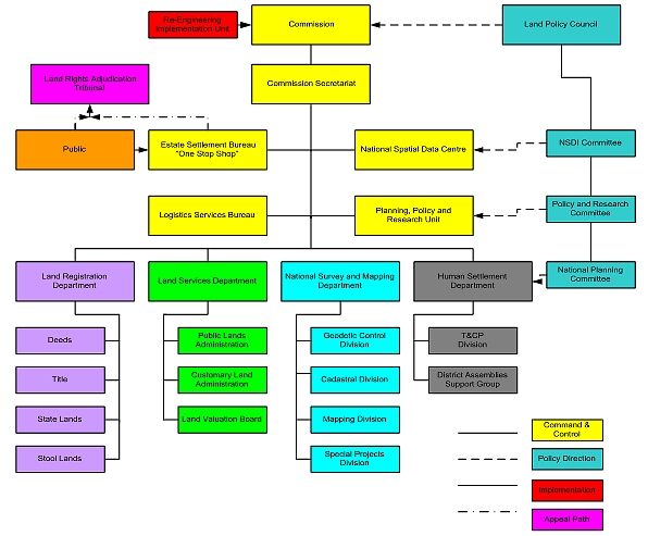
Source: Grant, 2004
Figure 2: The Land Administration Structure proposed by LAP the
Consultant
In Figure 2, a number of key features are easily recognisable:
- the Land Policy Council (now the Land Sector Policy Committee (LSPC)
of LAP) is expected to provide policy advice on National Land Policy to
the new Commission; the Steering Committee functions for the LAP will be
conducted by a Committee of the Land Policy Council;
- a One-Stop-Shop (Estate Settlement Bureau (ESB)) is to be adopted
where clients could have all requests on land met at a point of call. This
is to be interfaced with a Land Rights Adjudication Tribunal where the
outcome of all transactions and any Alternative Dispute Resolution or
conflict resolution may be provided subject to appeal to the Tribunal;
- National Spatial Data Infrastructure (NSDI) where an integrated
national spatial information will be developed;
- Logistic Services Bureau (LSB) where all supporting services, legal,
financial, public relations, management services and corporate facilities
will be housed;
- an Internal Audit Unit will be attached to the Board of Commissioners
for appropriate tasking and auditing within the total agency;
- the existing Land Agencies will be reorganized into four operating
departments: Land Registration Department, a Land Services Department, a
National Survey and Mapping Department, and a Human Settlement Department
(if TCPD is to be part of the One-Stop-Shop); and
- staffing and pay scales of the Commission Secretariat and Operating
Departments will be independent of civil service recruitment rules and all
conditions of service harmonised.
Whilst the consultant thought it possible to achieve a complete
integration of land administration services along functional lines, which
will require the merging of some units and the elimination of others and
preferred the inclusion of the Town and Country Planning Department (TCPD)
within the MLF, the LAP is pushing for a linkage between the two whilst
still resourcing the TCPD under the LAP (see Figure 3).
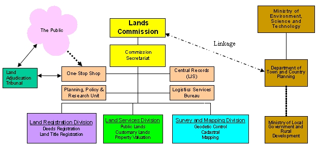
Figure 3: The Land Administration Structure
proposed by LAP to Cabinet, December 2005
Again, the NSDI initially proposed by the Consultant to be part of the
new Lands Commission structure, has given way to a LIS unit that may be
linked to Ghana’s NSDI (NAFGIM) 2)
that ought to be truly national, representing a whole-of-government
approach to gathering, sharing and presenting geo-referenced information;
and this is better placed under the National Development Planning Commission
or under the Office of the President.
2) Investigations at
the Environmental Protection Agency indicate that NAFGIM is now more or less
defunct and ought to be ‘resuscitated’.
The next part of this paper zeros in into the (Central Records) LIS
segment in Figure 3, examining in some detail LIS implementation issues. A
two-pronged approach is employed: firstly, a broad discussion on a GIS
co-ordinating mechanism for the lands agencies is established and a GIS
configuration at that level proposed. Focus is then directed to the agencies
to examine the envisaged structure and processes of GIS implementation in
the LAP and the role of the agency’s future implementation team. Thereafter,
the initial implementation requirements of the LCS including the
institutional arrangements for the GIS project implementation under
the project are considered, dwelling also on the role of GIS as a planning
support tool. Secondly, approaches and sources to learn best practices in
GIS implementation are provided as a checklist.
3. LIS PROJECT IMPLEMENTATION: THE RELEVANT ISSUES
The LAP envisages a holistic approach in the introduction of GIS in land
sector agencies. Some co-ordinating mechanism has to be established for
these agencies in GIS implementation at the very outset, even before the
envisaged one-stop-service. A phased-out incremental approach is advocated.
Figure 4 shows a schematic framework for co-ordinating land sector agencies
as they currently exist.
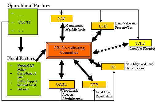
Figure 4: Proposed GIS co-ordinating mechanisms
for the Agencies
Before Figure 4 is discussed, it is important to mention that a GIS
organisational model for the agencies would have to be based on the fact
that the LAP is gunning for the merging of the land agencies as one body. It
has, however, been noted by experts that the very nature of corporate
working (through the adoption of the enterprise model) was problematic and
that since its adoption may warrant major structural changes in
organisations involving huge financial outlays, the corporate/enterprise
model had never been actually used even by local authorities where they were
expected to be adopted widely (Campbell and Masser, 1995; Local Government
Management Board (1993); Reeve and Petch, 1999).
The proposition that, in the initial stage of implementation, each agency
should be re-engineered and strengthened as individual bodies since
re-engineering will involve creating centres of information about land
administration, land values and taxes et cetera involving the coordination
of organisational and technological change ought to be taken seriously. The
issue then would be ensuring proper networking arrangements between the
existing agencies (after re-engineering) under the GIS Coordinating
Committee that will operate as a Land Information and Management Advisory
Board, with links to Ghana’s SDI, NAGIM. GIS has a critical role to play in
this and whilst there is need for organisational reform, the ‘big bang’
approach cannot be a viable option, technically. After the merger of the
agencies the above ‘departmental approach’ may metamorphosize into a ‘GIS
enterprise model’ but only after care consideration based on empirical
evidence.
Referring back to Figure 4, each agency will have to use appropriate
suite of methodologies (for example Critical Success Factors
(CSF)/Performance Indicators (PI)) and others where appropriate
(constituting operational factors)) to determine its needs in relation to
the overall national need (need factors, that look at national GIS goals,
land as a resource, the role of custodians of such lands, the public as
stakeholders and issues relating to datasets) whilst being co-ordinated by
the GIS Coordinating Committee. The Committee is expected to oversee data
integration and ensure increased capacity for data sharing, instilling the
concept of information as a corporate resource into all the land agencies.
Each individual organisation’s long term plan must relate directly to the
long-term plans of the central government (LAP) it serves (Huxhold, 1991).
For GIS implementation, there should be clear lines of responsibility for
each participating agency and adequate incentives that allow work to be done
constructively to achieve the GIS project objectives.
What should the LIS configuration for Ghana’s land sector under the above
co-ordinating mechanism be like? It is suggested that it comprises three
basic sections namely a ‘land database’, a ‘spatial analysis and modelling’
component and a ‘user products’ element. The land database may be divided
into three sections namely cartographic data files (maps), attribute data
file (descriptive data) and manual registers (see Figure 5 below).
Ideally, spatial analysis and modelling may have four sections. It would
utilise software with capabilities for vector and raster operations where
appropriate. It is important that standards exist to ensure effective and
efficient data sharing among agencies. Applications must conform to existing
practices and procedures simplified with the aid of expert systems and
numerical models where appropriate (Lai and Wong, 1996). A Data Base
Management System (DBMS) would be used for querying operations and
interpretation of data. It is expected that some manual systems such as
‘index’ filing would run concurrently with computer-aided information
systems.
Roles of the various departments must be spelt out early. For example
cadastral boundaries and topological base maps must be the responsibility of
the SD whilst land use maps must lie within the purview of the TCPD working
closely with SD as with all other agencies. The end result will be map
generation and generalisation (spatial data queries and analysis),
interpolation maps (land resource appraisals), querying procedures and
interpretation of the attribute data (DBMS), and prototyping and simulation
studies (expert systems and models) where appropriate.
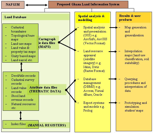
Source: after Chidley et al. (1993)
Figure 5: Proposed GIS configuration for Ghana’s land sector
The first requirement is the automation of the agencies GIS
non-spatial database. “It is costly to collect, store and shift through
large quantities of unnecessary data. Hence, the most cost effective
approach is to collect only the data required for the specific tasks…”
Yaakup et al, 1995, p. 731). Non-graphical data in the agencies have resided
in files and are quite well indexed but most of this will still have to be
converted into digital format. It may be necessary to start with a simple
database like Microsoft Access and scale this up to Oracle in
the future. The building of spatial databases using ArcGIS, for
instance, with a customised interface can then follow at which stage
accurate master addresses or proper owner data sets would have been
obtained.
The next part of the paper dwells specifically on how implementation may
occur within those agencies.
There is to be a GIS Project Team at the Head Office (headed by a
qualified but high-ranking officer (co-ordinator)), which is expected to
play an internal co-ordinating role and be the source of technical
information for all sections of the agencies. The team will encourage user
participation, develop local expertise, demonstrate the effectiveness of GIS
technology through research and innovation and liaise with NAFGIM on GIS
standardisation and networking issues. The GIS Departments at the regional
levels will help transfer GIS technology to the regions directly and
supervise the district offices. Both regional and district levels will be
responsible for GIS implementation and therefore are to be seen operational
units. At the district level, “NGOs by their nature of their field
presence, can potentially serve as vehicles to support the transfer of GIS
technology to the district administration” (Sahay and Walsham, 1996, p.
392).
It is to be noted in Figure 5 that this proposed GIS structure must be
integrated into the present agencies systems, headed by the respect Heads of
Agencies, as far as is practicable. What is to be addressed are the roles of
these Heads of the Departments after merger. Would it be practical to make
them GIS ‘experts/godfathers’ (Reeve and Petch, 1999) and GIS ‘Project
Co-ordinators’ as well? Another issue are the roles of the new Regional
bosses as the administrative heads of the regions. Do they become hybrid GIS
managers (Reeve and Petch, 1999)? In other words, do they all necessarily
have to be retrained to become the GIS experts at the highest level in the
head office and the regions in the long run? Even though this is highly
recommended, the principal actors and users of the GIS project must
themselves decide on this. In this respect, it must be acknowledged that GIS
is to be implemented in a context in which there are going to be differing
opinions and priorities that have to be harmonised. There is a need,
therefore, to devise mechanisms that aim at maximising synergy between the
different actors and users or implementers of the GIS project (Sahay and
Walsham, 1996).
As a corollary, another critical issue is supervision of work in the GIS
units. Who supervises work at the agencies and what is to be the specific
role of the GIS Coordinating Committee? An allusion was earlier made to some
of these roles. However, it is important to state that each agency, that is
now administratively independent, is to have separate GIS teams whose role
it is to mainly develop “an appropriate set of methods for collecting,
analysing, storing and sharing information and subject these to technical
and [spatial] analysis” (Fox, 1991, p. 65). The Committee’s role will
then be catalytic only, focusing on pushing for renovations of existing
buildings to house the GIS units, ensuring training and appointment of
well-trained staff, scouting and purchasing and installing equipment
knowledgeably and seeking management support, among others. It is expected
to “either include, or allow for participation of local interest such as
private enterprises, community groups and non-governmental associations
concerned with spatial information for [land administration] purposes”
(Fox, 1991, p. 65). The Committee must ensure that there is standardisation
of data through constant contact with NAFGIM if revitalized.
Table 1 shows examples of GIS strategic planning and choices using a bar
chart that may engage the attention of the Committee. Arrows suggest that
activities are to be sustained for a lengthy time period. After installing
equipment, for instance, they ought to be upgraded periodically over a long
period. The comprehensive long-term plan of LAP of 15 years and above will
ensure that analyses and constant appraisal of the needs of the agencies
will be consistent with the individual goals of the agencies and thus
prevent unrealised expectations and disappointments (Huxhold, 1991).
Appointment of well-trained staff, for instance, can begin shortly before
feasibility study is completed and before GIS application starts. The
acquisition and installation of GIS must be approached with a strategic plan
and choices made under a stable management environment to ensure
sustainability (de Man, 1996; Madziya et al., 1989; Geertman and Stillwell,
2002).
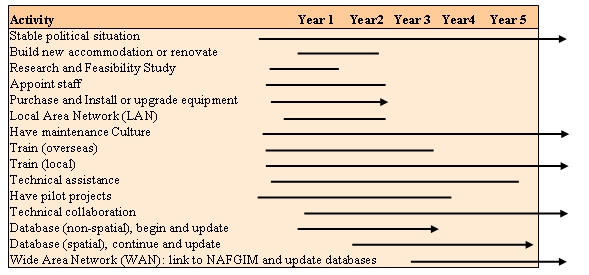
Table 1: Example of some national GIS strategic choices using a bar
chart
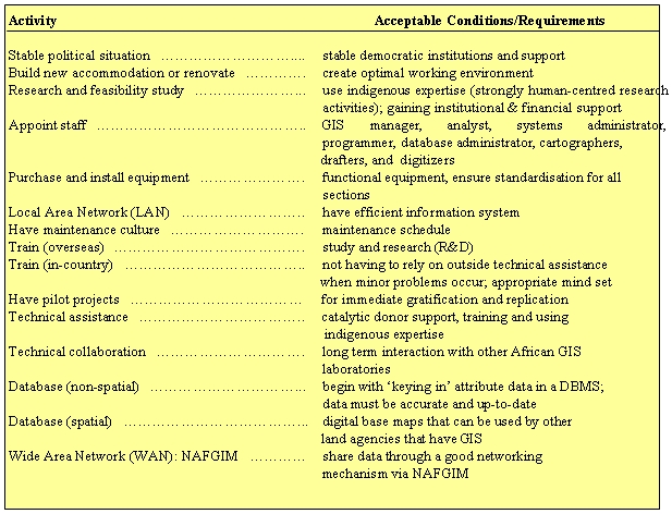
Table 2: Conditions and requirements associated with GIS strategic
choices
It is hoped that the first three years of GIS implementation will be
devoted to training of core staff abroad, providing a LAN to all agencies
whilst training in-house. Collaboration with other (African) GIS
laboratories is recommended and a maintenance culture should be cultivated
and sustained throughout the project’s life span.
Table 2 above shows the conditions and requirements associated with the
choices as indicated in Table 1. In the appointment of staff, whilst is may
be necessary to get appropriate job descriptions like the ‘systems
administrator’ in the initial stages, because the agencies would want to
develop their own applications in future, ‘computer specialists’ may later
to be seen as ‘experienced advisors or facilitators’ rather than as experts
leading the process (Reeve and Petch, 1999).
The next part of this paper relates the agencies to the national
strategic plans and choices elaborated above. Some guided steps are provided
to determine the readiness of the agencies for GIS use (Wiley, 1997).
The development of GIS must be tailored to suit specific organisations as
objectives and circumstances vary and each approach would therefore require
a different plan and treatment. A sequence of six steps has been found as
useful guide in the case of the Agencies. Each step provides a specific
activity, or a set of activities and their outputs provide information for
subsequent steps. Constraints to the introduction to GIS may be social,
economic, environmental or institutional or even legal and the design of any
interventions must be explicit. Interventions must recognise the capacity of
government, the agencies and staff to implement them and the resources
available must be specified early (Fox, 1991).
Step one: The agencies must have proper organisational structures. They
are expected to have layouts of office space and capacity to ensure the
suitable placement of equipment and easy physical circulation of staff. The
present structures in some agencies appear to create congestion. A long-term
approach of creating suitable accommodation should be included in strategic
planning of the agencies, including determining the agencies institutional
constraints on GIS use. LAP is expected to address these. The agencies
should, however, each have revised organisational charts detailing hierarchy
of responsibilities and clearly defined roles. It is worthy to note that it
was not until 1998 that an attempt was made under the prompting of the Civil
Service Performance Improvement Project (CSPIP) for any of such agencies to
have such charts.
Step two: The agencies must ensure that there are data standards for
their operations. Standards may consist of GIS guidelines on both spatial
and non-spatial data usage. Standards include the quality, reliability,
classification, accuracy and resolution of graphical and attribute data. The
agencies are expected to have good basic standards that can facilitate the
integration of other agencies’ data resources, ensuring accurate data sets
and maps.
Step three: The appropriate staff (with requisite training) must be
available (Fox, 1991; Edralin 1991). Computer specialists would be needed to
provide network support (support advisors) (Reeve and Petch, 1999). Drafters
and cartographers must be involved from the very beginning as they would be
expected to conduct updates and ensure maintenance to the database. The
transfer of trained staff should be done with some circumspection as
unplanned transfer of key project staff would create implementation
difficulties (Sahay and Walsham, 1996).
Step four: The agencies must have appropriate funding. Investments in GIS
require the need for availability of adequate funds for maintenance,
upgrades and updates of equipment and software. Future budgets must start
with current budgets and the agencies must find out what it is spending now
on information management and project into the future (Wiley, 1997). The
public and other users must pay for services provided to recover partial
expenses of the GIS development.
Step five: The agencies must create and have a maintenance culture. It is
pertinent to note that ‘the Ghanaian has no maintenance culture’ and
therefore programmes to ensure that all equipment remain functional at all
times is critical to GIS operations. An Estate Manager with knowledge in
facility management, a Database Administrator and a Systems Administrator
responsible for maintaining the system in a continuous operational mode,
among others, must be employed.
Step six: The agencies must ensure data sharing. Since this would be the
agencies first attempt at seeking data integration with other agencies, they
must embrace the policies on data standards and sharing; and the role of
NAFGIM as a ‘SDI and Clearing House unit’ in Ghana is crucial in this
respect.
The above six steps and the detailed procedures, are by no means
exhaustive, and should not be followed rigidly or sequentially as they are
not to be seen as linear. They could be varied and adapted to make the best
of every situation at any one point in time. What is important is to
understand the purpose of each step or detailed procedure and modify or
change them to suit specific circumstances. It is not being projected here
that without these requirements, GIS cannot be initiated as these are only
guides for effective implementation of GIS in the agencies at the
micro-level.
With GIS, as with any planning support systems, the agencies must list
their GIS tasks and identify staff and users who will operate the system,
set out the resources needed and estimate the time needed to accomplish
various tasks and activities. They must also have on their drawing boards,
which tasks are to be completed before others are commenced, draw up work
plans for their projects as a whole, draw individual personal work plans and
allocate money and equipment appropriately. In much more detail, they must
arrange administrative matters and logistics well in advance such as
checking and arranging security clearances for staff and equipment in the
use of maps and computers. They must budget for staff, equipment and
transport costs, provide and co-ordinate technical support in consultation
with LAP and make provisions for contingencies and iteration of steps in the
GIS planning process (FAO, 1993).
The GIS projects must be made to evolve and systems development must take
place in an incremental manner (Sahay and Walsham, 1996). On this score, it
may not be too appropriate to begin with a critical path analysis as changes
are expected to occur frequently. Based on the concept of a preceding
activity, a critical path analysis is a task which has to be completed
before another can be started (FAO, 1993). However, a detailed work plan
(e.g. a planning table or bar chart) as indicated above, when followed but
underpinned with modifications and innovations as changes would allow, can
be an invaluable tool to GIS implementation success in the agencies.
What issues are to guide the agencies in implementing GIS? The next part
of this paper will be devoted to actual experiences of GIS implementation
findings and their sources to help learn useful lessons. This operates as a
checklist for GIS implementation (see Table 3 below). It has become
imperative to learn from best practice and experience in GIS development so
as not to be seen to be reinventing the wheel.
|
Lessons reported about institutions or individuals in GIS
implementation
|
Madziya et al. (1989):
- political support is critical;
- public organisations need low-risk GIS solutions; and
- acquisition must be approached with a strategic plan.
Rourk (1989):
- institution process flows to be altered or replaced by the GIS must be
well understood;
- employees must be involved in the development; and
- lines of communication among developers, users and management must be
established.
Levinsohn (1989):
- all agencies affected should be involved early in the process;
- full range of key decision makers, line managers and technical staff
should be involved throughout;
- executive commitment is highly important; and
- consensus building is required as opposed to implementation by
directive.
Fox (1991):
- failure to adopt a new technology because of constraints has
consequences and foreseen consequences can become constraints;
- culture of government organs strongly influence the adoption of
information technology;
- establishment and operation of these systems require a large number of
specialist with broad experience and knowledge; and
- organisations are affected by their structure and order.
Sahay and Walsham (1996):
- balance between technical and social;
- transitions to GIS are made in a gradual rather than an abrupt manner;
- actors must work together as a team for the progress of the project;
and
- develop mechanism that maximises synergy between actors.
Campbell (1994):
Four factors that enhances successful GIS implementation:
- simple applications fundamental to the work of potential users;
- user directed implementation involving all stakeholders;
- awareness of the limitations of the organization; and
- high degree of organisational stability or the organisation’s ability
to cope with change.
Lai and Wong, (1996):
There must be:
- simultaneous adjustments between users practices and technological
evolution;
- changes in operating procedures, service provision and power relations
in organisations;
- integration of local (indigenous) knowledge and established
(exogenous) knowledge;
- standardisation of development visions to gain common ground among
major participants;
- progress toward achieving systems that are easy to use; and
- long-term development that requires continual funding and elaborate
support infrastructure.
Speer, (1997):
- the presence (or absence) of ‘project champions’ will likely dictate
the success (or failure) of the project.
Reeve and Petch, (1999):
- GIS project leaders need to be sensitive to the nuances of the
organisation in which they work; and
- People are the key to GIS success.
Nebert (2001): On the concept of SDI
- ensure key government, commercial and value-added data/related service
providers are represented as key stakeholders in the development and
implementation of national SDI;
- collaboration of government data suppliers on coordinated, supportive
policies that relate to spatial data access and distribution including
availability of free data, pricing, copyright and use/integration of
electronic commerce;
- an access infrastructure and policy that is non-threatening to
stakeholder mandates;
- sustainable long term business models;
- early and clear indication of the role of the private sector;
- early marketing and promotion of the entire SDI programme;
- awareness and adoption of international standards;
- organisations must prioritise their data;
- organisations to collect metadata a little at a time; and
- organisations must publish their metadata using OpenGIS Consortium
Catalogue Services Specification.
Geertman and Stillwell, (2002)
- characteristics of the policy context (e.g. democracy or dictatorship)
influence the preferred technology and the way it is used.
Dunn, (2002)
- appropriate uses of GIS were those that consider first the political,
social and institutional context before providing technical evaluation;
and
- those projects that are most likely to fail are those in which
technocratic ‘quick fix’ approaches are adopted.
Karikari, Stillwell and Carver (2003a)
- the successful initiation [and implementation] of GIS pilot
projects by Ghanaian experts will depend on a strong financial base
and a strong management support (with GIS champion(s) playing vital
roles);
- strong management support and strong financial base
would indicate the readiness for GIS use [and implementation];
- the readiness for GIS [implementation] would depend on the
political and economic situation of the country with donor countries
playing catalytic roles; and
- any successful GIS prototype or pilot must be well
documented to ensure continuous funding (from within) and
therefore ensure sustainability.
Karikari, Stillwell and Carver (2003b)
- if NAFGIM is it to ensure the full realisation of the potential of
geospatial information technologies, then it must resuscitated and made to
develop a strong business case and have an aggressive campaign to sell the
concept of SDI in Ghana.
Table 3: Typical examples of GIS
implementation findings to help learn useful lessons
|
4. RECOMMENDATIONS
Ghana’s Land Sector Agencies must:
- determine that envisaged LIS pilots are administratively workable with
the view to involving the ultimate end users (the public and custodians of
land); have a phased approach, starting with research or adaptive work
(involving these pilot projects) that is scaled up subsequently as
experience demands, before a full-scale application is embarked upon;
- involve requisite staff from the outset;
- ensure that prospects are reasonable that adequate funding will be
available from within (current budget) and if needed from without
(LAP financial assistance);
- improve their performance through more stable appointment policies;
- reassess the staff strength with the view to rationalising their
structures and promoting competent professional staff on the basis of
merit;
- clarify their obligations and prerogatives with the objective of
ensuring accountability of management;
- give a sustained effort at building up their information systems and
analytical capacity through human resource development and research;
- evolve strategies aimed at removing or reducing corruption to improve
their image;
- improve conditions of service and pay levels;
- retrain professional staff to cope adequately with work processes
through a focused and continuous training programme (including study
tours/conferences) in IT, GIS and land related courses;
- create sinking funds or revolving funds from the very outset to be
replenished periodically, purely for maintenance of equipment and
back-ups;
- have an internal independent audit teams;
- ensure that charges on services provided are determined by the
interplay of the forces of supply and demand as far as practicable;
- improve financial performance by removing or reducing waste, raising
operating efficiency, exercising better control of inventories and
improving billing and collection of ground rents among others;
- set milestones, pausing and ascertaining reasons for successes chalked
and problems encountered; and have these well documented during and after
each pilot’s implementation stage;
- recognise that appropriate staff with training in IT and GIS will be
sine qua non in their work processes and in the successful
implementation of the LAP;
- recognise that once trained, such professionals need to be motivated
to stay in LC through incentives and good remuneration;
- recognise that cultural change is needed if LAP is to be successful;
- consider making data analysis on land data part of the agency’s
mission;
- acknowledge that Ghanaians lack a maintenance culture and recognise
that the ‘triad’ in IT are hardware, software and expertise; and
that maintenance of equipment and upgrading of software and back-ups must
be planned from the very outset and carried out promptly following
well-planned maintenance schedules;
- watch attitudes; and
- concentrate on the Big Picture (LAP).
It is recommended that LAP itself be repositioned:
- LAP should restrict itself to facilitating and monitoring the project.
(It should ensure project management/control, monitoring and evaluation
only);
- components of LAP, with the exception of Component 4 (dealing with
monitoring and evaluation and project management), must be headed by
Agency Team Leaders based as much as possible on current mandates. Agency
Team Leaders must be empowered;
- implementation must occur at ‘Implementation Agency’ level where all
pilots, including GIS ones, must be done: There is the need, in this
regard, to develop a deep sense of ownership by making use of the LAPs
Regional Co-ordinators as far as practicable; and
- LAP must resource and strengthen the Agencies and relevant
stakeholders by providing sustained logistical support, material and human
resources development. Procurement must be decentralised to these agencies
as far as practicable).
5. CONCLUSION
The underlying concern in this paper is that land must be better managed
in Ghana, and this involves a better land-information management, the
monitoring and modelling of such phenomenon as land use change and
encroachments. In this context, it is observed that the successful
implementation of GIS to support land administration in the lands sector in
Ghana will be confronted with a series of challenges: the need to provide
frameworks within which GIS can evolve as a tool in an orderly way in the
Land Sector Agencies; the need to find ways to democratise GIS in land
administration and management systems and structures within Ghana; the need
to generate designs that are innovative and practical so they will meet
specific land sector needs; and the need to provide support infrastructure
and services that will enable GIS to operate effectively and efficiently in
the lands sector in relation to other sectors. Each of the agencies will
have to be re-engineered, at the very outset, to improve efficiency and
effectiveness in the delivery of services that are provided to the user.
This calls for the urgent need to identify weaknesses, bottlenecks,
inefficiencies, duplication, threats and opportunities in respective
agencies. On this note, the agencies must recognise that major problems to
be overcome in improving land information practices will be organisational,
managerial and human based. It is the way in which the responsibility for
land data is to be allocated and distributed between institutions, how
records are to be kept and administered and on the skill and education of
the people who are expected to run these systems that would determine their
success and failure, and not the technology employed (Karikari et al. 2005,
p. 358).
REFERENCES
- Campbell, H., 1994, How effective are GIS in practice? A case study of
British local government. International Journal of Geographic Information
Systems 8, 309-325.
- Campbell, H., 1996, Theoretical perspective of diffusion of GIS
technologies. In Masser, I., Campbell H., and Craglia M., (eds), 1996, GIS
Diffusion: Adoption and Use of Geographic Information Systems in Local
Government in Europe (London: Taylor & Francis).
- Campbell, H., and Masser, I., 1995, GIS and Organisations: How
Effective are GIS in Practice (London: Taylor & Francis).
- Carter, J. R., 1989, On defining the Geographic Information System. In
W. T. Ripple (ed.), Fundamentals of Geographic Information Systems: A
compendium (Falls Church: VA., ASPRS/ACSM).
- Chidley, T. R. E., Elgy, J., and Antoine, J., 1993, Computerised
Systems of Land Resources Appraisal for Agricultural Development, Land and
Water Division, FAO.
- De Man, W. H. E., 1996, Geographical information technology in support
of local planning and decision-making: Challenges and opportunities for
Southeast Asia. In Tung Fung et al., (eds), GIS Asia, 195-199.
- Dunn, C., 2002, GIS for development in lower-income countries. ITC
News, No.1, Enschede, The Netherlands, 27-28.
- Edralin, J., 1990, Conference Report - International Conference on
Geographical Information Systems: Application of Urban Regional Planning,
Nagoya, UNCRD: 1.
- FAO, 1993, Guidelines for Land-Use Planning, Food and Agriculture
Organisation of the United Nations Development Series 1, Rome.
- Fox, J. M., 1991, Spatial information for resource management in Asia:
A review of institutional issues. International Journal of Geographical
Information Systems, Vol. 5, No. 1, 59-72.
- Geertman, S., and Stillwell, J., 2002, Planning Support Systems in
Practice (Heidelberg: Springer-Verlag).
- Grant, D., 2004, Institutional Arrangements, Lands Sector, Ghana,
Unpublished Paper, Ministry of Lands, Forestry and Mines, Accra.
- Huxhold, W. E., 1991, An Introduction to Urban GIS (New York: Oxford
University Press), 230-268.
- Karikari, I., Stillwell, J., and Carver, S., 2003a, Land
administration and GIS: The case of Ghana, Progress in Development
Studies, 33, 223-242.
- Karikari, I., Stillwell, J., and Carver, S., 2003b, GIS adoption in
Ghana’s lands sector agencies: futuristic organisational model and
development stages for the Accra Lands Commission Secretariat (LCS). Our
Common Estates, RICS Foundation.
- Karikari, I., Stillwell, J., and Carver, S., 2005, The application of
GIS in the lands sector of a developing country: Challenges facing land
administrators in Ghana, International Journal of Geographical Information
Science, Vol. 19, No. 3, 343-362.
- Lai, P-C and Wong, M-K, 1996, Problems and prospects of GIS
development in Asia. In Tung Fung et al., (eds), GIS in Asia: Selected
papers of the Asia GIS/LIS, AM/FM and Spatial Analysis Conference,
219-229.
- Levinsohn, A. G., 1989, A strategic planning based approach to the
design of land information systems. Proceedings of the Urban and Regional
Information Systems Association, Vol. 2: 30-38.
- Local Government Management Board, 1993, Benchmarking Guidelines: A
Guide to Evaluation (Luton: LGMB).
- Madziya, R.G., Mattiussi, R., and Willis, G., 1989, Doing it right: An
information management system. In Bijan Azad (ed.), Proceedings of the
Urban and Regional Information Systems Association, Vol. 3, 1-9.
- Meltz, S., 1988, An approach for implementing land information systems
for rural and urbanising counties. Surveying and Mapping, 48, 35.
- Nebert, D. D. (ed.), 2001, Developing Spatial Data Infrastructures:
The SDI Cookbook, Technical Working Group, Global Spatial Data
Infrastructure (GSD1), Version 1.1, May.
- Reeve, D. E., and Petch, J. R., 1999, GIS, Organisations and People: A
Socio-technical Approach (London: Taylor and Francis).
- Rourk, R. W., 1989, Conquering the GIS implementation curve through
successful pilot project studies. Proceedings of the Urban and Regional
Information Systems Association, Vol. 2, 76-87.
- Sahay, S., and Walsham, G., 1996, Implementation of GIS in India:
Organisational issues and implications. International Journal of
Geographical Information Systems, Vol. 10, No. 4, 385-404.
- Speer, E. D., 1997, Implementation Issues of GIS Applications in
Developing Countries, (http://www.esri.com/library/userc…oc97/proc97/to
- accessed March 2001).
- UNCHS (HABITAT), 1990, Guidelines for the Implementation of Land
Registration and Land Information Systems in Developing Countries: with
Special Reference to English Speaking Countries in Eastern, Central and
Southern Africa, Nairobi.
- Wiley, L. 1997, Think evolution, not revolution, for effective GIS
implementation. GIS World Inc., 10, 4, 48-51.
- Wiley, L. 1997, Think evolution, not revolution, for effective GIS
implementation. GIS World Inc., 10, 4, 48-51.
- Yaakup, A., Ibrahim, M., and Johar, F., 1995, Incorporating GIS into
Sustainable Urban and Regional Planning: The Malaysian Case. Proceedings
of Geoinformatics ‘95, Vol. II, Hong Kong, 26th - 28th May, 728-736.
BIBLIOGRAPHY
Dr Isaac Bonsu Karikari is a Principal Lands Officer with the
Lands Commission, Accra. He is a Core Team Member (Advisor on Land
Administration) to the Millennium Challenge Account (MCA), Ministry of
Finance and Economic Planning, Ghana and the Lands Commission’s Team Leader
of the World Bank’s supported Land Administration Project. He is also the
Head of Geographic Information Systems, Training and Manpower Development
Unit of the Commission). He is an Associate Member of the Ghana Institution
of Surveyors, Chair of the Research and Development (R&D) Sub-Committee of
General Practice Division of that Institution; a Member of the Board of
Examiners (BOE) of General Practice Division; and Local Chairman, Scientific
Committee for the 5th FIG Regional Conference on ‘Promoting Land
Administration and Good Governance’, Accra, Ghana, March 9-12, 2006.
CONTACT
Dr Isaac Bonsu Karikari
Lands Commission Secretariat
PO Box CT 5008
Cantonments
Accra
GHANA
Tel. + 233 21 777325 (office)
Fax + 233 21 761840
Mobile: + 233 24 3103439
Email:
drisaackarikari@yahoo.co.uk
 |


