Article of the Month -
March 2011
|
Data Quality of Global Map and Some
Possibilities/Limitations for Its Wide Utilization for Global Issues
Bashkim IDRIZI, Macedonia (FYROM),
Pal NIKOLLI, Albania
Murat MEHA and Ismail KABASHI, Kosovo

Bashkim Idrizi |

Pal Nikolli |

Murat Meha |

Ismail Kabashi |
 This article in .pdf-format
(16 pages, 476 KB)
This article in .pdf-format
(16 pages, 476 KB)
1) This paper has been presented at
the joint Commission 3 and Commission 7 Workshop in November 2010 in
Sofia. It has been selected as the article of the month because it gives
a good introduction on Global Map, its consistent quality and data
standards and its value as a handy tool to monitor the environmental
status at regional and global scale. FIG has also selected this paper as
recognition of the professional development in Albania, Kosovo and
Macedonia (FYROM)
Key words: global map, utilization of GM data, data
harmonization, non/homogeneous data
SUMMARY
Global map was borne as a product to replace previous IMW
(1:1.000.000) with a new map in digital form with the homogeneous
standards for entire globe. The primary objective of Global Map is to
contribute to the sustainable development through the provision of base
framework geographic dataset as necessary for better understanding the
current situation and changes of environment in global level. The Global
Map datasets encompass the entire globe at a scale of 1:1.000.000 (for
vector data) and spatial resolution of 30 arc seconds (for raster data).
Global Map with its consistent quality and data standards is a handy
tool to monitor the environmental status at regional and global scale,
which may have limited uses at national and local scales. It also
provides a framework within which the local environmental problems can
be modeled and analyzed with appropriate data. Disaster prevention,
disaster mitigation, preserving Biodiversity, promoting regeneration
processes of the ecosystem etc. are some of GM targets.
Due to fact that the GM data from geometrical point of view is
basically partially topologically and non harmonized data coming from
different sources (NMO’s), our efforts for its utilization for map
compilation and spatial analyses resulted with limitations because of
overlaps and gaps between the polygons, as well as non spatial joint
between the line objects. The GM specification allows to each
participant to use different sources with different quality for
different areas of their countries and for different layers. This type
of definition of non-homogeneous accuracy without any process of data
harmonization in some way allows overlaps, gaps, and non spatial joint
of data not only between different countries, but the data within the
same country and between different layers.
The relation between the data of raster and vector layers, resulted
with big differences, basically because of non-homogenous accuracy
between the vector and raster data, and non-harmonized data, as well as
because of the differences on the defining of the level zero from the
participant countries.
The above situation can be overcome by including the data
harmonization process as necessary step during the process of preparing
the global map data, which should be defined in global map
specification. This process might be very difficult, because of some
mentioned political problems above, however it is necessary step for
better future of global mapping project and wide utilization of global
map data.
1. INTRODUCTION - GLOBAL MAPPING PROJECT
The idea for developing the global map was lunched as a result of
unsuccessful completing the IMW (International Map of the World in scale
1:1.000.000) and contemporary trends that imposed information technology
in the last decade of last century for preparing the digital maps. Based
on this idea, global map should replace the IMW with a new map in
digital form with the homogeneous standards for entire globe (Idrizi B.
et all, 2010).
It is therefore essential that access to the most accurate and
up-to-date maps of important environmental features, aimed for properly
understand of our global environment. In general, available maps of the
entire globe originate from various sources and therefore their accuracy
is inconsistent, mainly because of irregularities in source material,
lack of up-to-date data, gaps in the data, etc. Insufficient
circulations of existing map information and a concern for national
security have also reduced the availability of maps at a global scale.
The concept of Global Map, also including the establishment of an
international body for Global Mapping project, was firstly proposed by
the Ministry of Construction (MOC) of Japan in 1992. The MOC concept was
to build global scale geographic information through international
cooperation. In the same year, the “Earth Summit” - the United Nations
Conference on Environment and Development (UNCED) - in Rio in June 1992
also addressed the issue of information access, where international
organizations and institutions around the globe agreed to provide and
share Global Map information about the state of the globe and its
changes. The report of this conference includes mention of the need for
global mapping project, stressing the importance of public access to
information and international cooperation in making it available.
In year 1994, in Izumo-Japan was held the first international
workshop on global mapping, where was resolved that global map
development should proceed with a goal of completion by the year 2000.
Two years later, on February 13th 2006, in Tsukuba-Japan, the second
international workshop on global mapping has been held, where the
International Steering Committee for Global Mapping (ISCGM) was
established, which officially started with work after its first meeting
in 14th February 1996. The Global Mapping project and its activities are
organized and coordinated by ISCGM, a body of professionals from various
countries with secretariat placed at Geospatial Information Authority of
Japan (former Geographical Survey Institute – GSI), as a center of the
Global Mapping project. The GSI is actively involved in the ISCGM and
provides technical assistance among others for the development of the
Global Map.
After establishment of the committee, ISCGM supported by United
Nations was put down the letter addressed to all National mapping
organizations around the world with invitation for participating in the
project through developing global map of their countries under certain
specifications already notified by the secretariat. Through its
continuous efforts ISCGM has succeeded in making “Global Mapping” as
part of the “Plan of Implementation” of World Summit on Sustainable
Development (WSSD) held in Johannesburg, Aug-Sep 2002 also.
Global mapping is an international collaborative initiative through
voluntary participation of national mapping organizations of the world,
aiming to develop globally homogeneous geographic data set at the ground
resolution of 30 arc seconds and to establish concrete partnership among
governments, NGOs, private sectors, data providers and users to share
information and knowledge for sound decision-making. Global Mapping is
both a project and a process for developing a group of digital
geographical information datasets.
The primary objective of Global Mapping project is to contribute to
the sustainable development through the provision of base framework
geographic dataset, which is necessary to understand the current
situation and changes of environment of the world.
ISCGM has so far approved and published 5 Global Map Specifications,
i.e. the first specification (Version 1.1) on 16.03.2000, Version 1.2 on
17.04.2005, Version 1.2.1 on 11.11.2006, Version 1.3 on 14.07.2007, and
the last one Version 2 on 25.10.2009. The data structure within the
Global Mapping project is adopted in to ISO/TC 211 standards for
geographic information, i.e. ISO19136 for GML format, ISO 3166 for
nation codes, ISO 19115 standard of metadata of V2 by using ISO 19139
for encoding, ISO 15046 standard of metadata of V1, ISO639 for language
code, ISO8601 for date code (GM specification V1.3./V2). The scheme of
standards for data developing defined in global mapping project is shown
in next figure.
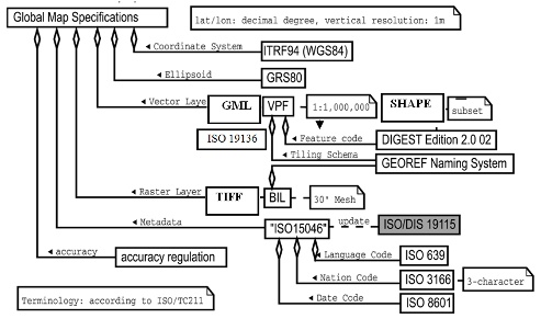
Figure 1. Scheme of standards in Global Mapping project
2. GLOBAL MAP DATA
The Global Map datasets encompass the entire globe at a scale of
1:1.000.000 (for vector data) and spatial resolution of 30 arc seconds
(for raster data), consistent with Global Map specifications. Spatial
features are organized into thematic layers in either vector or raster
formats with each layer containing logically related geographic
information. Global Map contains four kinds of datasets:
- Global Map V.0
- Global Map V.X
- Global Map V1/V2 (national and regional version) and
- Global Map V1 (global version).
Two first datasets, V.0 and V.X are not so popular and up-to-date
data. The GM V.0 is based in Vmap level 0 data, Global Land Cover
Characterization (GLCC), and GTOPO 30 elevation data set, contains four
raster layers (vegetation, land cover, land use and elevation),
developed as global geographic datasets without any validation of NMOs.
As GM V0, the GM V.X is based in existing global geographic datasets,
tentatively developed with expectance to be improved in GM V1/V2.
2.1 Global Map V1/V2 – national and regional version
The GM V1/V2 national and regional version is most popular and most
utilized global map dataset, produced by National Mapping Organizations
of respective countries under their responsibility, without any
responsibility assume of ISCGM for the contents of data. It contains
eight layers, four vector layers (populations centers, drainage,
transportations and boundaries) represented in VPF, Shape and/or GML
formats, and four raster (elevation, land cover, land use and
vegetation) layers in TIFF and/or BIL format.
| Vector Layers |
Raster Layers |
| Transportation |
Elevation |
| Boundaries |
Land Cover |
| Drainage |
Land Use |
| Population Centers |
Vegetation |
Table 1. Global Map V1/V2 data set layers
- national/regional version
GM vector data of V1/V2 (national and regional version) stored as
edges and faces are individually structured, which means that GM vector
data is partly topologically structured, with intense to keep the
logical consistency of data, and non duplicate features.
GM raster data of V1/V2 (national and regional version) is organized
and accessed by rows and columns with the cell size (spatial resolution)
30”x30”, with the origin on the north-west corner of the tile. The
attribute of each cell represent a characteristic that is dominant
nearby the center point of cell, stores band by band for each line, or
row, of the image. Three out of four layers (vegetation, land cover and
land use) are in 8 bit unsigned data, and the fourth layer (elevation)
data in 16 bit signed in Motorola (big-endian) byte order (Idrizi B. et
all, 2010).
2.2 Global Map V1 – global version
The GM V1 global version was developed as additional raster data
aimed to replace existing raster layers (land cover, land use and
vegetation). It contains two raster layers, Land cover and Vegetation
(Percent tree cover), all of them available on BIL and TIFF formats,
with the same spatial resolution of 30”x30” as raster data of national
and regional version, with the origin being the north-west corner of the
tile. GM V1 (global version) data are uploaded and available for
utilization in Google Earth (figure 2).
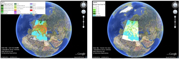
Figure 2. Global map V1 (global version) in Google Earth
The data were created by using MODIS data observed in 2003 (TERRA
Satellite), with cooperation between participating NMOs and Center for
Environmental Remote Sensing (CEReS), Chiba University, coordinated by
ISCGM (Tateishi R., 2005).
2.3 Mathematical elements of global map data
The reference coordinate system of Global Map is ITRF94, and its
longitudes and latitudes are defined in GRS80 Ellipsoid, stored in
decimal degrees to a minimum of three decimal points as geographic
coordinates with southern and western hemispheres having a negative sign
for latitude and longitude. Since the difference between ITRF94+GRS80
and WGS84 is negligible in spatial resolution and scale of Global Map,
WGS84 can be used also (GM specification V1.3./V2).
The positional accuracy of spatial data based on the composite errors
from three sources: which are the positional accuracy of source
material, errors due to conversion processes, and errors due to the data
processing. For horizontal accuracy, 90% of points need to be within
±2km of their actual location, and in the case of data obtained from
satellite images, the maximum error is less than or equal to 0.5km. In
other site vertical accuracy is notionally ±150m for 90% of points (GM
specification V1.3./V2).
GM data is in use of GEOREF tiling naming system, which does not
allow overlaps or gaps between the tiles, with the the reference for
their southwest corner. It uses two pairs of letters. The first pair of
letters represents the coarsest, 15° by 15° standard GEOREF division,
and represents the first coordinate pair identifying the tile name. The
second pair of letters represents the 1° by 1° standard GEOREF
divisions, and represents the second coordinate pair of the tile name.
In the other site, the tiling system of GM V1 global version uses the
dividing system of 30° x 30° starting from the equator and the Greenwich
meridian (Idrizi B., et all, 2010).
3. POTENTIAL UTILIZATION OF GLOBAL MAP DATA
Environmental issues are closely interlinked one leading to another.
A local environmental problem may grow into regional or even global
environmental problem, and a global environmental degradation may create
a new environmental problem in various other parts of the globe hitherto
unaffected by it or it may aggravate the existing local problems. This
is precisely because a global outlook is essential to understand the
environmental problems affecting our surroundings and to provide a
holistic solution towards the same.
Majority of environmental issues could be referenced to changes in
Land Cover, Land Use due to manmade and natural causes (deforestation,
desertification and loss of biodiversity), and industrial activities
(air and water pollution, toxic wastes etc.). Due to the geographic
nature of the majority of environmental issues, spatial analysis becomes
an essential tool for environmental assessment, monitoring, and
integrating environment, and development concerns for addressing such
questions as: what is happening where, why, and how the problem is being
solved. In the past, assessment and monitoring of anything on a global
scale were practically impossible due to lack of globally consistent and
comprehensive spatial datasets and of the ability to effectively analyze
and use such large volume of datasets. Consequently, most of the
monitoring and assessment activities were concentrated over small areas
and the results derived often generalized for larger areas. The lack of
suitable geographical dataset was one of the most serious impediments to
the integrated spatial analysis and modeling (Idrizi B., 2006).
Global Map with its consistent quality and data standards is a handy
tool to monitor the environmental status at regional and global scale.
With the Global Map dataset being in digital form, it lends itself to
various data manipulation and for modeling real life situations. Global
Map dataset may have limited uses at national and local scales. However,
Global Map dataset is needed to address global, regional, trans-boundary
and in many cases national concerns.
Global Map dataset when combined with other data can yield future
estimation in various fields like water resources, floods, land use in
model calculation, so that preventive measures can be taken. It also
provides a framework within which the local environmental problems can
be modeled and analyzed with appropriate data. Disaster prevention is
also possible, if adequate measures are taken based on the information
through modeling. Disaster mitigation is another area wherein Global Map
data can be used to effectively address the issues of relief measures.
It is helpful in preserving Biodiversity and in promoting regeneration
processes of the ecosystem. The following are some of the potential
applications of Global Map datasets:
- Monitoring and early warning systems for natural disasters;
- Monitoring and management of natural resources;
- Assessment of the trends of global environment changes;
- Local, national and multinational physical development planning;
- Informed decision-making of policy makers with a strategic
database;
- Global/Regional/National perspective and contextual information;
- Developing ecosystem, drainage basins framework for
environmental assessment;
- Quantifying trans boundary issues;
- Rapid Response capability;
- Environmental priority setting, analytical studies over large
areas, ext.
4. RESEARCH FOR THE DATA QUALITY OF GLOBAL MAP
The advanced capabilities of researching based on Global Map data
set, with aim to be realized upper potential applications of Global Map
datasets are (Idrizi B., 2005):
- all data of Earth is in one place,
- with the same attributes,
- in the same format,
- in the same coordinate system
- in the same scale, and
- with similar accuracy.
By comparing of advanced capabilities from one site, global map data
structure/standards from the other site and potential-projected
utilizations of global map data from the third site, many limitations
for its wide utilization have been recognized, mainly because of non
harmonized data between the participant countries. Below some results
from our research on level of utilization of global map data as major
global environmental dataset will be presented.
4.1 Utilization of Global Map data for spatial analyses between
two or more neighboring countries
The global map data specification defines that contents of all
received data by the national mapping organizations will not be modified
(GM specification version 2, 2009), but they will be checked out for
compatibility with the GM data structure (standards) and published as
they were received, without any process for harmonization of the data
between the neighboring countries. The main problems which comes from
this rule of global mapping project results with overlapping or gaps
between the polygon objects such as national boundary, lakes etc., as
well as non spatial joint between the line objects such as roads,
railways, rivers etc. Such a kind of situation is a result of several
factors of different natures from the technical up to the political,
accumulated in many decades-centuries, which cannot be overcome so
easily:
- Utilization of source data with different scale, accuracy and
entireness;
- Utilization of source data with different period of collecting
and non up-to-date data,
- Utilization of tendentiously data,
- Accuracy of the transformation of coordinate system,
- Data generalizing,
- Partially topologically structured data,
- Lack of bilateral agreements between neighboring states for the
border line,
- Various conflicts between neighboring countries,
- Non-recognition of States between themselves, etc.
Topology of GM as defined in its specification "Vector data in the
Global Map will be partially topologically structured. Features stored
as edges and faces will be individually structured”, does not allow full
spatial joint between objects in different layers and objects between
two data sets.
Due to fact that the GM data from geometrical point of view is
partially topologically and non harmonized data coming from different
sources (NMO’s), our efforts for its utilization for map compilation and
spatial analyses resulted with limitations because of overlaps and gaps
between the polygons, as well as non spatial joint between the line
objects. Example which prove the above deficiencies are shown in the
next figure 3, example along the borderline between Bulgaria and
Romania. Absence of spatial continuity condition and appearance of
overlaps/gaps prevents the utilization of this database for spatial
analysis of the global issues etc.
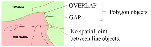
Figure 3. Part of GM data along the borderline between Bulgaria
and Romania
The above situation can be overcome by including the data
harmonization process as necessary step during the process of preparing
the global map data, which should be defined in global map
specification. This process might be very difficult, because of some
mentioned political problems above, however it is necessary step for
better future of global mapping project and wide utilization of global
map data.
4.2 Global Map accuracy
The GM specification allows GM data to have a different accuracy
depending on the source data, where the difference can be up to four
times (for 90% of point’s ±2km, and ±0.5km if the data comes from
satellite images). If we convert dimensions of both errors in to printed
map as hard copy, they are 2mm to 0.5mm, which are values much larger
than the standards for mapping in scale 1:1.000.000.
In fact this specification allows to each participant to use
different sources with different quality for different areas of their
countries and for different layers. This type of definition of
non-homogeneous accuracy without any process of data harmonization in
some way allows overlaps, gaps, and non spatial joint of data not only
between different countries, but the data within the same country and
between different layers.
4.3 Relation between the vector and raster Global Map data
Because of some upper recognized problems in utilization of global
map data for global issues, the relation between the data of raster and
vector layers, as example the overlapping of lakes, seas and oceans with
DEM (digital elevation model) have been a part of our research analyses.
After several analyses of more than 20 examples, the differences
resulted as much larger than projected accuracy for vector data and
spatial resolution of the raster data.
Above result can be seen in the next figure 4, in overlapped
situation between the Bulgarian coastline along the Black Sea and DEM,
as well as in the Brazilian GM dataset as overlapped vector data with
DEM, where the differences in some places are more then 3-4km.
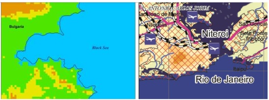
Figure 4. Differences between the vector data and DEM
Upper differences between the coastline and DEM beside the
non-homogenous accuracy between the vector and raster data, and
non-harmonized data, are coming from the differences on the defining of
the level zero from the participant countries. This type of data is
allowed in the GM specification, “the vertical distance between the
surface of the earth and the standard sea level that the nation has
defined” (GM specification 2&1.3, ISCGM, 2009).
4.4 Utilization of attribute unknown (UNK) in global map dataset
On the existing GM data available for download from the ISCGM’s web
page, a large number of data with the attribute UNK (unknown) can be
listed. This is an option given at the GM specification for all data
with unknown attributes such as: unknown name of the river, unknown type
of usage of airport, unknown seasonal availability of roads, etc.
In other site, according to legal obligations on their own countries,
national mapping organizations should possess native spatial data
followed by their accompanying attributes. Due to fact that they are
representatives of their countries in the global mapping project,
utilization of UNK attribute about the unknown data is unreasonable and
unacceptable for us.
In such a situation in which from one site we have NMO’s as owner of
native spatial data followed by their accompanying attributes, and in
other site we have GM dataset with large number of unknown data
attributes, derives the question: why the NMO’s have been used the
attribute UNK?! Based on our research, probably the NMO’s have used the
given opportunity by the GM specification, and not really because their
institution or other responsible state institutions for spatial data
don’t have the native information they possess.
4.5 The accuracy of highs in DEM (elevation layer)
Calculating the accuracy of the heights within the Macedonian global
map data set, have been made by defining the test model with 2191 points
within the territory of Macedonia, extracted from the Macedonian
topographic maps in scale 1:25000 with 10m interval. By comparing the
test points with the Macedonian GM DEM, has been calculated the root
mean square error (RMSE) for Macedonian GM DEM dataset which has the
value RMSE=88m, which is within the projected accuracy of heights in GM
specification of ±150m.
From the list of test points, 217 out of 2191 points, approximately
10% of total test points, has the difference larger than ±150m, i.e.
about 90% of points has the height error within ±150m (according to GM
specification V1.3./V2). Maximum error find out from the test model was
460m.
From 217 points with the larger difference than ±150m, 3 of them (1%)
has the error between 400-460m, 7 points (3%) with error between
300-400m, 76 points (35%) with error between 200-300m, and 131 other
points (61%) with error between 151-200m.
Three characteristic slopes of terrain within the Macedonian GM DEM
have been analyzed also (figure 5). First analyzed situation is terrain
with average slope of 55%, where the maximum difference between the
source data and the pixel value of DEM is 530m. The second situation is
terrain with average slope from 56% to 63%, where the maximum difference
of about 500m has been recognized. In third case of terrain with average
slope of 20%, the maximum recognized height difference was about 100m.
All above obtained results show the influence of the slope of terrain on
accuracy of the GM DEM.
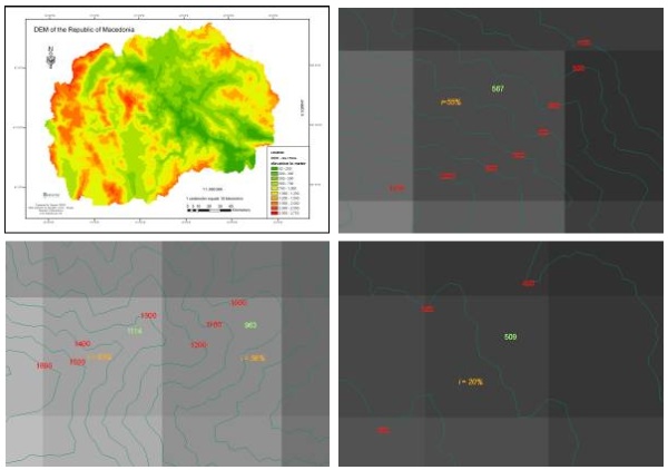
Figure 5. Overlapping of contours and DEM (Idrizi B., 2005)
4.6 Global map specification and mapping standards
Basically the idea for global mapping project was to replace the
previous IMW (1:1.000.000) with a new map in digital form with the
homogeneous standards for entire globe called global map. But if we take
a look to the structure of global map since the beginning till today,
namely its standards listed in its specifications, it is so clearly that
global mapping is not designed as a standard map, but it represents the
GIS database format with specific defined standards. The lack of
cartographic key (cartographic symbols), the lack of
cartographic/graphic representation, and absence of defined map
projection are the main arguments which prove that global map it isn’t
map but it is GIS database, i.e. global map oneself does not contain the
basic elements that characterize a map. Based on these details, comes
the expression mapping element which should be subject for GM revising
in the next period by orienting the project in this regard (Idrizi B. et
all, 2010).
Because of the non defined cartographic standards within the global
map, nowadays exists many maps prepared based on the GM datasets, free
downloadable from the ISCGM’s web site (http://iscgm.org/cgi-bin/fswiki/wiki.cgi?page=Application)
with total difference map design, starting from the map scale up to the
map symbols. In bellow two maps, the differences between the same types
of map with the same scale prepared from the same dataset from the same
organization can be recognized. The differences are coming as a result
of absence of defined standards for global map symbols and its design.
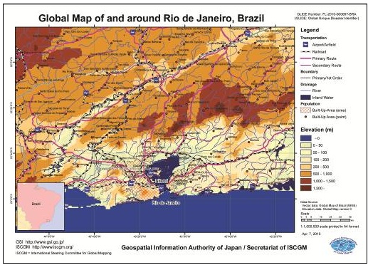
http://www.iscgm.org/cgi-bin/fswiki/wiki.cgi?action=ATTACH&page=Application/disaster/201006-bra&file=1006_bra_el.pdf
(April 7, 2010)
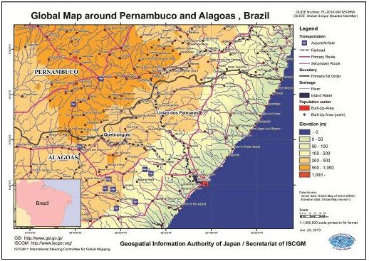
http://www.iscgm.org/cgi-bin/fswiki/wiki.cgi?action=ATTACH&page=Application/disaster/201004-bra&file=1004_bra_el.pdf
(June 23, 2010)
4.7 Relation between the GM vector layers
Due to the global map rule defined in GM specification that the data
is partially topologically structured, relation between the GM data
contain vector layers is very poor, even the data which must be analyzed
because of the natural relationship between them, for example:
- The relation between the boundary line and road, in a case when
road represents the boundary between two administrative regions;
- The relation between the river and boundary line, in a case
where river represents the boundary between two administrative
regions or countries;
- The relation between the road and lake-sea-ocean;
- The relation between the population centers and roads;
- The relation between the roads and rivers; ect.
In the next figure 6 is given an example of GM data in which because
the absence of the relation between the population centers and
transportations layers, many cities have not any connection with any
type of road. But, is it possible to exist any population centre (city
or village) without connection to any type of road?! Of course it is
impossible. Because the vector data in the Global Map is partially
topologically structured, full spatial analyses between objects (road
network and population centers) in different layers are not possible.
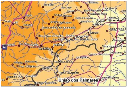
Figure 6. Population centers without connection to road network
5. CONCLUSIONS
Global map was borne as a product to replace previous IMW
(1:1.000.000) with a new map in digital form with the homogeneous
standards for entire globe. The primary objective of Global Map is to
contribute to the sustainable development through the provision of base
framework geographic dataset as necessary for better understanding the
current situation and changes of environment in global level. The Global
Map datasets encompass the entire globe at a scale of 1:1.000.000 (for
vector data) and spatial resolution of 30 arc seconds (for raster data).
The GM V1/V2 national and regional version is most popular and most
utilized global map dataset, produced by National Mapping Organizations
of respective countries under their responsibility, without any
responsibility assume of ISCGM for the contents of data. In the other
site, the GM V1 global version was developed as additional raster data
aimed to replace existing raster layers (land cover, land use and
vegetation), which contains two raster layers (Land cover and Percent
tree cover), available in Google earth also.
The data structure within the Global Mapping project is adapted in to
ISO/TC 211 standards for geographic information, i.e. ISO19136, ISO
3166, ISO 19115, ISO 19139, ISO 15046, ISO639, and ISO8601.
The horizontal accuracy of 90% of points need to be within ±2km of
their actual location, and in the case of data obtained from satellite
images the maximum error should be less than or equal to 0.5km. In other
site vertical accuracy is notionally ±150m for 90% of points.
Global Map with its consistent quality and data standards is a handy
tool to monitor the environmental status at regional and global scale,
which may have limited uses at national and local scales. It also
provides a framework within which the local environmental problems can
be modeled and analyzed with appropriate data. Disaster prevention,
disaster mitigation, preserving Biodiversity, promoting regeneration
processes of the ecosystem etc. are some of GM targets.
Due to fact that the GM data from geometrical point of view is
basically partially topologically and non harmonized data coming from
different sources (NMO’s), our efforts for its utilization for map
compilation and spatial analyses resulted with limitations because of
overlaps and gaps between the polygons, as well as non spatial joint
between the line objects. The GM specification allows to each
participant to use different sources with different quality for
different areas of their countries and for different layers. This type
of definition of non-homogeneous accuracy without any process of data
harmonization in some way allows overlaps, gaps, and non spatial joint
of data not only between different countries, but the data within the
same country and between different layers.
The relation between the data of raster and vector layers, resulted
with big differences, basically because of non-homogenous accuracy
between the vector and raster data, and non-harmonized data, as well as
because of the differences on the defining of the level zero from the
participant countries.
The above situation can be overcome by including the data
harmonization process as necessary step during the process of preparing
the global map data, which should be defined in global map
specification. This process might be very difficult, because of some
mentioned political problems above, however it is necessary step for
better future of global mapping project and wide utilization of global
map data.
REFERENCES
- Idrizi B. 2005. Global map action plan of the Republic of
Macedonia; ISCGM; Tsukuba; Japan.
- Idrizi B., 2006. Developing of globally homogeneouses geographic
data set through global mapping project. Zagreb. Croatia.
Cartography and geoinformation.
- Idrizi B., 2007. Globaly understanding the current situation and
changes of environment of the world. Skopje. Macedonia (FYROM). Acta
Lingua Geographica.
- Idrizi B., 2010. Kosova in Global Map. Nessebar, Bulgaria. 3rd
ICCGIS.
Idrizi B., Meha M., Nikolli P., Kabashi I. 2010. Overview on Global
Map as contributor of GSDI.
- Skopje, Macedonia (FYROM). SDI 2010-Skopje conference.
- ISCGM. 2007. Global Map specification version 1.3;
www.iscgm.org
- ISCGM. 2009. Global Map specification version 2;
www.iscgm.org
- Kishimoto N. (2005): Process of GM development; handout;
Geographical Survey Institute; Tsukuba – Japan.
- Tateishi R. (2005): Report of the ISCGM working group 4 on
raster data development; Cairo. Egypt. Twelfth meeting of ISCGM.
- www.iscgm.org
- www.globalmap.org
- www.cr.chiba-u.jp/
BIOGRAPHICAL NOTES
Bashkim IDRIZI, was born on 14.07.1974 in Skopje, Macedonia
(FYROM). He graduated in geodesy department of the Polytechnic
University of Tirana-Albania in 1999year. In 2004, hot the degree of
master of sciences (MSc) in Ss.Cyril and Methodius University-Skopje. In
2005 he had a specialization for Global Mapping in Geographical-Survey
Institute (GSI) of Japan in Tsukuba-Japan. On year 2007, he held the
degree of Doctor of sciences (PhD) in Geodesy department of Ss.Cyril and
Methodius University–Skopje. He worked in State Authority for Geodetic
Works from May 1999 until January 2008. During those period, in 2004 he
appointed for head of cartography department, i.e. geodetic works. From
October 2003 up to January 2008, he worked as a outsourcing lecturer in
State University of Tetova. From February 2008, he works as a
cartography and GIS Professor at the State University of Tetova–Tetova.
He continuo with working as outsourcing lecturer in geodesy department
of the University of Prishtina-Kosova. He is the author of three
cartography university books, and more than 60 papers published and
presented in national and international scientific conferences related
to geodesy, cartography, GIS and remote sensing. From March 2010, he is
appointed as president of Geo-SEE (South-European Research Association
on Geo Sciences).
Murat Meha is a University Professor and Deputy Head of the
state Border Demarcation Commission. He has been teaching at the
University of Prishtina - Kosovo since 1988. He has also taught for ten
years at Tetova University (FYR of Macedonia). He worked for five years
as Manager of SEO Ferronikeli, for three years as a CEO of Kosova
Cadastre Agency, in different funded EAR projects, USAID project, KTA
etc. His teaching and research concern survey, cadastre, Land
Administration and Land management. and related educational and capacity
building activities. He is currently the member of Kosova Surveyor
Association. Main publications of Mr Meha are on survey, cadastre, Land
Administration and Land management. He published two University books,
two books for Kosovo Cadastre Agency, one book translated, and several
school geographic atlases and maps. More than 80 professional and
science papers in different professional magazines, symposiums,
conferences etc. Most of those articles are available on Internet at:
FIG, ICC, Euro Geographic, WPLA, CELKCenter, FAO GIM International etc.
Pal Nikolli Graduated at the Geodesy branch of Engineering
Faculty, Tirana University. In 1987 has been nominated lecturer in the
Geodesy Department of Tirana University. In 1994 has been graduated
Doctor of Sciences in cartography field. During this period, have taught
the following subjects: “Cartography” (for Geodesy and Geography
students) and “Geodesy” (for Civil engineering & Geology students).
Actually he is lecturer and tutor of the following subjects: “Elements
of Cartography” (for Geography students), GIS (for Geography students,
diploma of first and second degree) “Interpretation of Arial
Photographs” (for Geography students, diploma of first degree),
“Satellite Images” (for geography students, diploma of second degree)
“Thematic Cartography” (for Geography students, diploma of second
degree) and “Topography-GIS (for the Geophysics students, diploma of
second degree). Mr. Nikolli is the author and co-author 8 textbooks
(Elements of Cartography and Topography, Elements of Cartography,
Geographic Information Systems, Processing of satellite images,
Cartography, etc), 3 monographs (History of Albanian Cartography,
Mirdita on Geo-Cartographic view, etc), more than 40 scientific papers
inside and outside of the country, more 40 scientific & popular papers,
etc. Has participated in several post graduation courses of cartography
and GIS outside of the country (1994, 2000 - Italy), etc.
Ismail Kabashi, was born on 08.08.1965 in Prishtina, Kosova.
He graduated in geodesy department of the University of Saraevo-Bosnia
and Hercegovina in 1992year. In 2003 year, he held the degree of Doctor
of sciences (PhD) in Geodesy engineering department of TU Wienn–Vienna.
Currently he is employee in Vermessung ANGST GmbH ZT as project manager
for Planning and execution of Cadastre and Geomonitoring Projects. From
year 2004, he works as a geodesy engineering Professor at the University
of Prishtina-Kosova. He is the author of many papers published and
presented in national and international scientific conferences related
to geodesy and engineering geodesy, as well as the author of script for
students in geodesy engineering field.
CONTACTS
Ass.Prof.Dr. Bashkim Idrizi
Geo-SEE (South-East European Research Association on Geo Sciences);
State University of Tetova, Faculty of Natural Sciences and Mathematics.
Str. Xhon Kenedi, 25-4/20,
Skopje
MACEDONIA (FYROM)
Gsm: + 389 75 712-998
bashkim.idrizi@yahoo.com,
bashkim.idrizi@unite.edu.mk,
info.geosee@gmail.com
www.unite.edu.mk,
www.geo-see.org
Assoc.Prof.Dr. Murat Meha
Kosova Cadastral Agency;
University of Prishtina,
Prishtina
REPUBLIC OF KOSOVA
Gsm.: +377 44 120-958.
mmeha@yahoo.com
www.uni-pr.edu,
www.kca-ks.org
Assoc.Prof.Dr. Pal Nikolli
Tirana University, Department of geography,
Elbasan street, Faculty of History and Philology
Tirana
ALBANIA
Gsm.: +355 69 2472-451
palnikolli@yahoo.com
www.fhf.edu.al,
www.upt.al
Ass.Prof.Dr. Ismail Kabashi
University of Prishtina
Prishtina
REPUBLIC OF KOSOVA
Gsm.: +377 44 325-819
ikabashi@gmx.net ,
kabashi@angst.at
www.uni-pr.edu,
www.angst.at
 |


