Article of the Month - December 2019
|
The scope of LADM revision is
shaping-up
Christiaan Lemmen and Peter Van Oosterom, The
Netherlands, Abdullah Kara, Turkey, Eftychia Kalogianni, Greece, Anna
Shnaidman, Israel, Agung Indrajit, Indonesia, Abdullah Alattas, Saudi
Arabia
 |
 |
 |
| Christiaan Lemmen |
Peter Van Oosterom |
Abdullah Kara |
 |
 |
 |
 |
| Eftychia Kalogianni |
Anna Shnaidman |
Agung Indrajit |
Abdullah Alattas |
This article in .pdf-format
(38 pages)
The Land Administration Domain Model (LADM) has been
ISO standard for the past 7 years and is now undergoing a review. This
paper was presented at the 8th FIG Workshop on LADM, October 2019 in
Kuala Lumpur, Malaysia and reports on the background, the development of
Edition II, and the initial stage of the revision process where FIG
Commissions 7 ‘Cadastre and Land Management’, 8 ‘Spatial Planning and
Development’, and 9 ‘Valuation and the Management of Real Estate’; as
well as ISO/TC211; IHO and OGC cooperate.
SUMMARY
After two LADM workshops (Delft, March 2017 and Zagreb, April 2018)
and three ISO TC211 meetings, where also LADM revision meetings took
place (Copenhagen, May 2018, Wuhan, November 2018 and Maribor, June
2019) there is consensus growing towards the new scope of the standard.
This new scope is described in this paper, and it is no exaggeration to
state that there is a rather spectacular extension of Edition’s I scope.
Below a first impression.
Some of the existing parts of the current
version of LADM are being refined. The goal is that these refinements
will add more semantics to LADM, but are also backwards compatible. A
good example of such improvements are the Refined Survey Model (as part
of the Surveying and Representation Subpackage) and more rigid
representations of the various CodeList and the values they hold (adding
more structure and using sematic technologies to define meaning of
values).
The scope of LADM is extended with a valuation and fiscal
perspective. This concerns a conceptual data model in a LADM Valuation
Package that can be used to construct information systems for immovable
property valuation and taxation and offer a data exchange option.
Spatial planning/zoning with legal implications is a further
extension of the scope. This new LADM package implies integration of
spatial planning and land administration environments and thus, re-use
of zones from spatial planning as restrictions to land rights is
possible Both extensions have impact on the definition of land
administration: land administration is the process of determining,
recording and disseminating information about relationships between
people and land - informal, customary and formal use and property rights
- and about value and use of land
What is more, the Global Land Indicator Initiative
(GLII), seeks to derive a list of globally comparable harmonized land
indicators, using existing monitoring mechanisms, and data collection
methods as a foundation. Hence, the LADM is extended with attributes
allowing monitoring, based on those indicators.
Moreover, a foundation
for a Land Administration Performance Index is included in Edition II –
which is possible linked to existing global frameworks or initiatives.
Legal space and legal objects have their own geometries which are in
many cases not (or not completely) equal to physical space and physical
objects. Legal space can be linked now to physical objects in Edition II
– by identifiers or re-use of descriptions of space. The users of indoor
spaces create a relationship with the space depending on the type of the
building and the function of the space. Applying LADM allows assigning
rights, restrictions, and responsibilities to indoor spaces, which
indicates the accessible spaces for each type of user.
The LADM standard is as-published applicable to Marine Cadastres -
with special attention for the transition zone from land to sea and
Marine Spatial Planning (MSP). A normative reference to IHO S121 (Marine
Limits and Boundaries) based on the LADM principles is included in the
revised version of ISO 19152.
In addition to the extension of the various
parts of the conceptual model of LADM as described above, there are
other extensions to the scope. These can be characterized as steps
towards implementations. In addition to the conceptual model, the
intention is that LADM Edition II will also include the corresponding
technical models (CityGML, InfraGML, RDF, INTERLIS, BIM/IFC, GeoJSON).
Further, there will not only be attention for the information, but also
for the Land Administration processes. Finally, Edition II will also
include a methodology of how the develop a country profile.
The new scope is also paired with proposals of how to realize this
new standards content in Edition II. In this paper, we will shortly
highlight these solutions. More details can be found at the ISO 19152
Working Draft (WD 1), which has been prepared for the ISO TC211 meeting
in Maribor, June 2019. Not for all elements in the new scope is there a
proposal for how to realize this, and there is still a lot of work
ahead. Also, the current proposals, are just proposals, and they have to
go through the ISO consensus process, before becoming part of the new
standard. For sure, there will be changes ahead.
1. INTRODUCTION
The Land Administration Domain Model (LADM) is a knowledge domain
specific standard capturing the semantics of the Land Administration
domain. It provides a shared ontology, defining a common terminology for
land administration. The LADM covers basic information related to
components of land administration: including water and elements above
and below the earth's surface, as well as people. These components
concern: party related data; data on rights, restrictions and
responsibilities (RRRs) and the basic administrative units where the
RRRs apply; data on spatial units and on surveying and
topology/geometry. LADM also includes the Social Tenure Domain Model
(STDM).
The status as International Standard was obtained for LADM
(first Edition) in December 2012 (ISO, 2012). ISO standards, which are
being applied, are subject to periodic revision, typically in a 6 to
10-year cycle.
A UN-GGIM Meeting of the Expert Group on Land
Administration and Management was held on 14-15 March 2017, in Delft,
The Netherlands, and the main conclusion was that the revision of LADM
was indeed needed in order to provide better tools to improve tenure
security and better land and property rights for all, see also UN-GGIM
(2019) and Section 2. That Section also presents a recent OGC White
Paper in Land Administration (OGC, 2019) – this paper is about
operationalisation of LADM and other standards.
During the UN-GGIM
Workshop in Delft it was noted that land administration (LA) is a rather
complex domain, and thus the revision will involve many stakeholders,
namely: ISO, FIG, OGC, UN-Habitat, UN-GGIM, World bank, GLTN (Global
Land Tool Network), IHO, RICS, etc..
ISO/TC211 organized a voting from
15 October 2017 to 5 March 2018 on the systematic review of ISO
19152:2012, Geographic information -- Land Administration Domain Model
(LADM). The results were published on 22 May 2018 as ‘ISO/TC 211 N 4812’
(ISO, 2018) and confirmed the wish for the revision by the majority of
the ISO/TC211 P-members.
In order to prepare the LADM revision, two
FIG LADM Workshops were organized: one in Delft, the Netherlands, 16-17
March 2017 and the other one in Zagreb, Croatia, 11-13 April 2018, with
experts involved in the development of the initial version of LADM and
representatives of all the mentioned stakeholders (http://isoladm.org
).
The International Federation of Surveyors (FIG) submitted a New
Working Item Proposal (NWIP) to ISO on the development of the LADM
Edition II in April 2018. This New Working Item Proposal includes the
following scheduled main LADM extensions:
- Extended scope of
conceptual model. This includes: valuation information, SDG LA
indicators, Performance Index, linking legal objects with physical ones,
indoor models, support of marine spaces, spatial planning/zoning with
legal implications, support of other legal spaces: mining, archaeology,
utilities;
- Improvement of the current conceptual model. This
includes: formal semantics/ontology for the LADM Code Lists; more
explicit 3D+time profiles; an extended survey and legal models;
- Encodings/technical models towards LADM implementation. This includes:
further integration with BIM/IFC, GML, CityGML, LandXML, LandInfra,
IndoorGML, RDF/linked data, GeoJSON, and:
- Process models for survey procedures, map updating, transactions
– including blockchain.
This paper will further report on the initial stage of the revision
process where FIG Commissions 7 ‘Cadastre and Land Management’, 8
‘Spatial Planning and Development’, and 9 ‘Valuation and the Management
of Real Estate’; as well as ISO/TC211; IHO and OGC cooperate.
The rest of the paper is structured as follows: first, as a reminder,
a background and motivation for LADM is given in Section 2. Then an
overview of the current developments in relation to the LADM standard is
given in Section 3, then the requirements for the development of Edition
II are presented in Section 4, followed by an overview of some initial
proposals for the main new functionalities in Section 5. Based on
Sections 3 and 4 the draft of the new scope is included in Section 6. An
overview of proposed actions is presented in Section 7. It should be
stressed that these are proposals and initial developments of the second
Edition of the model. The conclusions are provided in Section 8.
2. LADM MOTIVATION AND BACKGROUND
In December 2015 a special issue of Land Use Policy was dedicated to
the Land Administration Domain Model, see Land Use Policy, Vol 49,
December 2015, pages 527 – 689. The motivation and background for LADM
was included in (Van Oosterom et al., 2015) in that special issue:
‘there is a need for domain specific standardisation to capture the
semantics of the land administration domain on top of the agreed
foundation of basic standards for geometry, temporal aspects, metadata,
and also observations and measurements from the field. This is required
for communication between professionals, for system design, system
development and system implementation purposes and for purposes of data
exchange and data quality management. LADM enables Geographical
Information Systems (GIS) and database providers and/or open source
communities to develop products and applications. And in turn this will
enable land registry and cadastral organisations to use these components
to develop, implement and maintain systems in an even more efficient
way. LADM provides a shared ontology, defining a terminology for land
administration. It provides a flexible conceptual schema with three
basic packages: parties, rights (and restrictions/responsibilities) and
spatial units. LADM supports the development of application software for
land administration, and facilitates data exchange with and from
distributed land administration systems. An important aspect in the
development of coherent (Spatial) Information Infrastructures(S)II is
that the various standardised domain models are reusing the same model
patterns as solutions for the same situations. The standard supports
data quality management in land administration. Use of standards
contributes to the avoidance of inconsistencies between data maintained
in different organisations, because data duplication can be avoided as
much as possible. It should be noted here that implementing a
standardised data model can be support-ive in the detection of existing
inconsistencies.’
The standard covers basic information-related
components of land administration including those over land, in water,
below the surface, and above the ground.
The standard is an abstract,
conceptual model with three packages related to: parties (people and
organisations); basic administrative units, rights, responsibilities,
and restrictions (ownership rights); spatial units (parcels, and the
legal space of buildings and utility networks) with a sub package for
surveying, and representation (geometry and topology) (Lemmen et al,
2015).
3. OVERVIEW OF DEVELOPMENTS
LADM and also STDM, the Social Tenure Domain Model, are currently
under implementation in several countries, see FIG (2017) and FIG
(2018a).
LADM is applicable in relation to the implementation of
relevant parts of the New Urban Agenda (UN, 2017), FAOs Voluntary
Guidelines on the Responsible Governance of Tenure of Land, Fisheries
and Forests in the Context of National Food Security (FAO, 2012) and the
Continuum of Land Rights as from UN-Habitat (UN-Habitat, 2008, Teo and
Lemmen, 2013). This fit, of course, very well into the context of
implementation of the Sustainable Developments Goals.
The
Fit-For-Purpose approach in Land Administration (FIG/World Bank, 2014;
UN-Habitat/GLTN/Kadaster, 2016) has been developed in reaction to the
challenges set by the overall Global Agenda for Sustainable Development.
The Fit-For-Purpose approach argues for cost-effective, time-efficient,
transparent, scalable and participatory land administration, including
Participatory Surveying, Volunteered Land Administration and
Crowdsourcing. The principle of the Fit-for-Purpose approach is that the
spatial, legal and institutional frameworks for Land Administration are
in balance in such a way that tenure security can be established and
maintained in a timely and affordable way, always aiming at facilitating
the local, regional or national needs.
The introduction of the
Fit-for-Purpose Land Administration can be considered as a new way of
thinking in achieving faster, cheaper and more appropriate land
administration systems for the world. In order to assure an easy and
adaptable interoperability layer with other stakeholders, the
Fit-For-Purpose Guiding Principles (UN Habitat/GLTN/Kadaster (2016) )
recommend that the data model chosen for the Fit-For-Purpose Land
Administration system should be based on (ISO 19152:2012) LADM and the
derived STDM.
The main developments with regard to LADM can be
summarized as follows:
- As a result of the voting (ending on 5
March 2018) on the systematic review of ISO 19152:2012 it became clear
that the majority of the ISO/TC211 P-members expressed their wish for
the revision. Also, a number of suggestions to be included in the
revision were given. Some quotes from the document ISO/TC 211 N 4812
(ISO, 2018): inconsistencies with other referenced standards that need
to be fixed, address other global issues such as cadastre for oceans,
issues as identified at TU Delft (http://isoladm.org/StandardMaintenance
) should be considered, broader collaboration with IHO, OGC, and FIG,
integration of land use and land cover information within the LADM
should be considered, growing need for providing land administration in
3D (below, on and above the surface of the Earth) on land as well as at
sea, mechanism to exchange LADM information (consider OGC’s
LandInfraGML), future development of RRR, etc..
- The New Working
Item Proposal (NWIP), as submitted on 30 April 2018 by FIG to the ISO
Technical Committee on Geographic Information (ISO TC 211), provides an
overview of needs and requirements discussed by international experts.
In this moment this New Working Item Proposal has not yet been accepted
by ISO TC 211 – reason is in the publication of LADM Edition II as a
multipart standard, see below under 12 of Section 2.
- ISO Stage 0
project \started in May 2018 during the 46th Plenary Meeting Week of TC
211 Copenhagen, Denmark. A potentially broader scope, including
fiscal/valuation extension module, more explicit semantics of code list
values, further modelling of the LADM's rights, restrictions,
responsibilities (RRRs), further modelling of LADM's survey and spatial
representation, functionality for monitoring SDG Indicators (aggregated
values at different levels), 3D/4D Cadastre, inclusion of spatial
planning/zoning with legal implications, functionality in LADM in
support of Marine Cadastre (esp. coastal zones), more explicit relations
with Building Information Modelling (BIM), new types of legal spaces:
mining, archaeology and utilities are issues of attention and to be
considered.
- There was a call for participants for the Stage 0
project on ISO 19152 LADM in September 2018. Then, during the 47th
Plenary Meeting Week of TC 211 in November 13th, 2018 in Wuhan, China, a
first meeting was held, regarding the approach and contents of the LADM
Edition II, followed by a second meeting on June 4th, 2019 in Maribor,
Slovenia, during the 48th Plenary Meeting Week of TC 211.
- Collaboration with partners – see Section 1 of this paper, is
crucial and mandatory during the revision.
- A White Paper on Land
Administration prepared by the Domain Working Group Land Administration
of the Open Geospatial Consortium (OGC, 2019) was discussed during the
World Bank Conferences on Land and Poverty on March 19th , 2018 and on
March 22nd , 2017. A cooperation between OGC and ISO is expected to
contribute to effective implementation and developments. The White Paper
highlights the operationalisation of LADM.
- Over the past years,
the Expert Group on Land Administration and Management of the United
Nations Committee of Experts on Global Geospatial Information Management
UN-GGIM developed a Framework for Effective Land Administration – FELA
(UN-GGIM, 2019). This is a reference for developing, reforming,
renewing, strengthening or modernizing land administration and
management systems. Land data are in the core of any land administration
and management system. The document calls for recognition of land
tenure, land use, land value, and land development data - including
elements relating to gender, conflict, and disaster - as fundamental
geospatial data themes within any jurisdiction - and that those data be
integrated with other fundamental themes. The document refers to the
Land Administration Domain Model as a standard for land administration.
- Besides the official English and French version, also an
informal Spanish translation of LADM is available. This was introduced
at the LADM Workshop in Delft, the Netherlands (2017). Action is needed,
as Spanish-speaking countries are very interested in adopting and
implementing LADM.
- An INTERLIS based application is under
implementation in Colombia and neighbouring countries are interested in
following this approach– this was pointed out during a special LADM
workshop in Quito, Ecuador in December 2018.
- In addition to the
above mention translations, there are further (draft) translations into
Russian, Chinese, Korean, and Czech of LADM.
- LADM Edition II should
maximize backwards compatibility.
- Standards Council of Canada (SCC)
proposed LADM Edition II as a multi-part standard with the extensible
base defined in Part 1 and a revision of the current ISO 19152 as Part
2. Land valuation and land use planning would be additional parts. After
the discussions in Maribor the following structure for the multi-part
option (as multiple coherent packages with every part in separate
standard) was suggested and agreed by the participants in that meeting:
- Part 1 - Land Administration Fundamentals
- Part 2 -
Land Tenure or Land Registration or Land Interest
- Part 3 -
Marine Space or Marine Geo-Regulation
- Part 4 - Land Valuation
- Part 5 - Spatial Planning
- Part 6 - Implementations
- RMIT University, Australia, states that the conceptual intention of
LADM v1 was to provide a data model able to function as a core of any
land administration system (LAS) worldwide. In reality, it is perhaps
unlikely that the countries with an existing and a well-functioning LAS
will implement a changeover to LADM. Hence, the practical value
proposition of LADM is more likely to lie in providing an
‘off-the-shelf’ model for managing land tenure information for those
countries for which structured digital land information systems are
either missing or under development. As a descriptive standard, it is
valuable as it is amenable to adaptation and extension by adopting
jurisdictions and able to suit a range of tenure arrangements. This is
further supported by the LADM specialization, the STDM. This is indeed
the reason why there is no interference with national laws that may have
any legal implications as written in the scope of the standard. LADM is
also a CEN (European Committee for Standardization) standard. Such
standard has legal impact in Europe. For this reason, the clause as
mentioned is included. On the other hand, it can be observed that
INSPIRE Cadastral Parcels is based on LADM. More interoperability
efforts (also in countries with well-functioning LAS) are expected to be
LADM based. See also the efforts from the OGC Domain Working Group on
Land Administration –a meeting of this Group is held in Leuven, Belgium
in June 2019. And also:
http://www.opengeospatial.org/projects/groups/landadmin .
4. REQUIREMENTS FOR LADM EDITION II
The first Edition of LADM should be upwards compatible with future
editions. Future editions may have an extended scope. LADM improvements
and extensions are needed – as well as LADM workflow/process models.
This section is based on the New Working Item Proposal as submitted by
FIG to ISO TC 211; see also Lemmen et al. (2018).
4.1 Extension of Conceptual Scope
A proposal to extend the scope of LADM with a valuation perspective
is presented in (Çağdaş et al., 2016, Çağdaş et al., 2017). This
proposal provides a data model that could be used to construct
information systems for immovable property valuation. The model is
designed especially for recurrently levied property taxation, but it can
also be used for other purposes of valuation (e.g. transaction,
compensation on expropriation, land readjustment, land consolidation,
insurance assessment). The proposal provides a common basis for
governments to direct the development of local and national databases,
as well as for the private sector to develop information technology
products.
The Global Land Indicators Initiative, (see UN Habitat/GLTN, 2017; UN
ECOSOC and African Union 2016), seeks to derive a list of globally
comparable harmonized land indicators, using existing monitoring
mechanisms and data collection methods as a foundation. Internationally
agreed standards will be key component alongside agreed global concepts
and evidence-based approaches. There is a need for a foundation of a
Land Administration Performance Index – which is a possible link to
existing global frameworks or initiatives.
Legal space and legal objects have their own geometry which is in
many cases not (or not completely) aligned with the physical space and
physical objects. Legal space should be linked with physical objects –
by IDs or by re-using of descriptions of space. BIM/IFC and CityGML
offer options in this respect. In general, for linking information (over
the web), RDF may be the preferred solution. The users of the indoor
spaces create a relationship with the space depending on the type of the
building and the function of the spaces. Applying LADM allows assigning
RRRs to indoor spaces, which in turn indicate the accessible spaces for
each type of user. An IndoorGML-LADM model is one example of linking
physical and legal objects one to another.
A normative reference to IHO S121 (Marine Limits and Boundaries)
based on the LADM principles needs to be included in ISO 19152 as well,
this will be one part of the LADM Edition II.
Spatial planning/zoning with legal implications is another issue to
consider. In principle, this is a matter of coding zones in code tables
(based on the local situations). This implies further integration of
spatial planning and land administration environments. Re-use of zones
from spatial planning into restrictions to land rights should be
possible.
Other legal spaces are related to mining, archaeology and utilities
(2D or 3D) should be addressed as well.
4.2 Further Improvements to be Included in LADM II
For the domain of land administration, the localization issue extends
from language names to the various organizations and institutions
dealing with interests in land.
Paasch et al. (2015) and Stubkjær et al. (2018) propose code lists as
a mean of internationalization by which the classes of the LADM may be
related to a particular jurisdiction. The issue of code lists has been
addressed by the OGC as well, namely in terms of the 17-050r1 Code List
Manifesto document (Scarponcini, 2017). Code lists need to be
semantically enriched, structured (SKOS) and versioned. Metadata and
tenure atlases are relevant in this context. Tenure atlases provide an
overview on tenure systems and the level of recognition. This may
include areas without land markets and nature preservation etc.
There is a model for representation of legal space allowing the
representation of volumes that are not completely closed (as needed
according the legislation in several countries).
More functionality is required for a complete partition of space:
more explicit 3D+time profiles. In addition to the current LADM
LA_VersionedObject, a bi-temporal model is considered, supporting
systematically both real world and systems times.
An extended survey model and legal model is needed. This implies
adjustments from field observations to the spatial database and the
generation of quality labels.
The Social Tenure Domain Model is proposed to be presented “closer to
the core” of LADM
4.3 Technical models (encodings) to be Included in LADM II
Encodings models concern the further detailed technical specification
of LADM and are based on existing standards: BIM/IFC, GML, CityGML,
LandXML, InfraGML, IndoorGML, RDF/linked data, GeoJSON.
BIM is very important in order to establish a link between BIM and
land administration in relation to spatial planning and lifecycles of
constructions/ buildings.
Open data is about Coding of Rights, Right holders, Spatial Unit
Types, etc. (see Informative Annex J of LADM (ISO, 2012) – W3C).
4.4 Workflows and Process Models
Cadastral map updating includes adjustments and transformations of
field observations (collected at different moments in time and with
different survey instruments or use of imagery from different sources)
to the spatial database. Management of areas is needed – there may be
more than one area to be maintained for the same spatial unit – the
legal area and the accurate area as calculated in the cadastral GIS.
Implementation of tolerances to manage the differences should be
flexible and purpose related. Results of subdivisions of spatial units
may need to be shared with other systems. This includes results of
readjustments and land consolidation.
Blockchain technology in transaction processes could be very well
applicable for transactions in land administration.
Conversion of social tenure to legal tenure is a process that may
require different levels (layers) with related attributes. The same is
valid for geometric quality improvements of the cadastral map.
A new class representing processes may be defined: a specialization
of the class representing sources – thereby creating a connection
between the classes of workflow management module and LADM classes.
Processes can be organized on the basis of use of electronic
signatures in case of applications and information requests with public
and private keys and encryption/decryption methods.
Provision of information to data collectors for initial data
collection or maintenance is a specific but very important process (task
management, logistics).
New approaches in Land Administration include Volunteered Land
Administration and Crowdsourcing. It is possible that right holders and
communities collect and maintain their own data with a certain level of
professional support for quality insurance etc. Participatory surveying
is possible with GNSS technology.
Conversion from social tenure to legal tenure may require
professional support – but it is easy to make this process complex and
complex to make it easy. The publication of parties’ related rights and
spatial units is also possible via global services (as may be Google,
Virtual Earth and Open Street Map and many others).
There will be a need for considerably more integration across the
various national data and information systems and platforms in order to
leverage the most effective data and analysis for evidence-based policy
formulation and decision-making. Image-based acquisition of cadastral
boundaries needs access to huge image libraries – including historical
imagery – to support large-scale implementations.
5. PROPOSED NEW FUNCTIONALITY IN LADM EDITION II
In this section a number of initial considerations related to
definitions and proposals for new functionality in LADM, see Figure 1 in
it’s Edition I, are introduced.
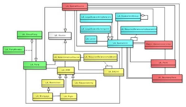
Figure – The
Land Administration Domain Model Edition I
5.1 Definition of Land
Standards Council of Canada proposes to replace or refine the concept
of "land" during the revision. This was discussed during the TC211
Meeting in Maribor. Specifically, in clause 1 of ISO 19152:2012, the
first sentence reads: "This International Standard: ⎯ defines a
reference Land Administration Domain Model (LADM) covering basic
information-related components of land administration (including those
over water and land, and elements above and below the surface of the
earth)…" This basically states that “land” should be interpreted as
“space”. However, to avoid confusion with NASA and ESA’s use of (outer)
space, it was decided to use the term “land” in the above wide context.
The current definition of land is: “the surface of the Earth, the
materials beneath, the air above and all things fixed to the soil”.
According to Canada this is based on private law and needs to be taken
into account. It may be good to consider this in order to introduce the
'3D partition of (legal) space’ term.
The new proposed definition for the term “land administration” in the
Working Draft 1 (pending discussion!) is: “land administration is the
process of determining, recording and disseminating information about
relationships between people and land - including informal, customary
and formal uses and property rights,- and information about value and
use of land.” We could further discuss to include “perceived security of
tenure” – see the indicator related to SDG 1.4:
https://sustainabledevelopment-uk.github.io/1-4-2/
5.2 Valuation Information Model
Property valuation systems require information related to property
units together with immovable property rights, therefore, it is
important to ensure that the units and the rights should have been
unambiguously identified. This is supported by the land administration
systems including cadastre and land registry. ISO 19152:2012 LADM is a
descriptive conceptual model that provides a reference for land
administration systems (FAO, 2017). The value component of land
administration is considered out of scope in the first version of LADM,
which actually provides a solid and flexible base for property
valuation. A group of researchers has recently developed the Valuation
Information Model by extending the ExtValuation class of LADM. The
purpose of the LADM Valuation Information Model is to specify the
semantics of valuation registries maintained by public authorities and
specify its relations with other land administration registries and
databases. It provides a conceptual schema for the data concerning
valuation units that are objects of valuation (e.g. cadastral parcel,
building and condominium), input and output data used and produced
through single or mass appraisal processes, parties involved in the
valuation practices, transaction prices and sales statistics (Cagdas et
al., 2016).
Classes in the Valuation Information Model Package receive a prefix
VM, short for “Valuation Model”. The main classes of the Valuation
Information Model Package are: (1) VM_ValuationUnit, (2)
VM_ValuationUnitGroup, (3) VM_SpatialUnit, (4) VM_Building, (5)
VM_CondominiumUnit, (6) VM_Valuation, (7) VM_MassAppraisal (8)
VM_TransactionPrice, (9) VM_SalesStatistic, and (10) VM_ValuationSource,
see Figure 2.
Valuation Units, as instances of VM_ValuationUnit, are the basic
recording units of the valuation registries, and are realized by an
aggregation relationship of VM_ValuationUnit onto itself, see Figure 2.
The object of valuation may be (a) only land (e.g. cadastral parcel),
(b) only improvements (e.g. buildings), (c) land and improvements
together as land property, (d) land and improvements together as
condominium property (McCluskey, 1999; Bird and Slack, 2002; Almy,
2014).
Valuation Units may be grouped in valuation unit groups, as instances
of class VM_ValuationUnitGroup, and realized by an aggregation
relationship of VM_ValuationUnitGroup onto itself, see Figure 2. A
valuation unit group may be a grouping of other valuation unit groups.
Valuation units may be grouped according to zones (e.g. administrative
divisions, market zones) that have similar environmental and economic
characteristics, or functions of valuation units (e.g., commercial,
residential, agricultural) that have similar characteristics.
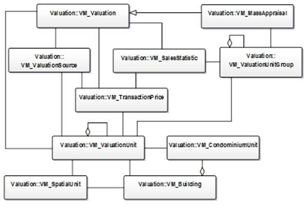
Figure 2 — Classes of Valuation Package
Class VM_SpatialUnit may represent cadastral parcels, as well as
sub-parcels that are subjects to valuation activities. VM_SpatialUnit is
a specialization class of LA_SpatialUnit.
Building represents physical spaces of buildings, building parts,
other constructions, and their characteristics in valuation activities.
A building may be considered as complementary part of parcels
(VM_SpatialUnit), but may be valued separately from the parcels on which
they are located. This class coincides with the physical space of a
building. A condominium building contains condominium units established
according to condominium schemes. This class is adopted from the OGCs
LandInfra standard (OGC, 2016). A condominium building consists of (i)
condominium units (e.g. apartments, shops); (ii) accessory parts
assigned for exclusive use (e.g. garages, storage areas); (iii) and
joint facilities covering parcel, structural components (e.g.
foundations, roofs), accession areas (e.g. entrance halls, spaces), and
other remaining areas of the building (e.g. staircases, heating rooms)
(Kara et al., 2018).
Condominium units as instances of class VM_CondominiumUnit. A
condominium unit is designated for the exclusive use of the individual
condominium owner and shares a condominium building.
Class VM_Valuation, as a counterpart of the ExtValuation external
class of LADM, specifies output data produced within valuation
processes, especially data for property tax assessment. It concerns date
of valuation, value type, valuation approach, and assessed value of
valuation units.
Class VM_Valuation has a class as specialization: Mass appraisal, as
instances of class VM_MassAppraisal. Mass valuation is a process of
valuing a group of valuation units using standardized procedures at a
given date. Class VM_MassAppraisal describes mathematical models, mass
appraisal analysis types (e.g., multiple regression analysis), and the
sample size of the analysis.
Transaction prices as instances of class VM_TransactionPrice. Class
VM_TransactionPrice characterizes the information content of transaction
contractor declarations, including the date of contract or declaration,
transaction price, date and type of transaction (e.g., sale, heritage,
forced sale, and rent prices).
VM_SalesStatistic, with sales statistics as instances. It represents
sales statistics produced through the analysis of transaction prices.
VM_TransactionPrice and VM_SalesStatistic serve valuation activities for
different requirements, e.g. estimating property values for property
taxation, expropriations, and monitoring price trends.
Valuation source as instances of VM_ValuationSource class. In
principle, property valuation is documented a valuation source, as
instances from class LA_ValuationSource.
5.3 Spatial Planning Information Model
It is common for countries to manage land tenure in a separate
mechanism than spatial planning (Enemark 2004). International Federation
of Surveyors (FIG) considers spatial plans as closely related to
cadastre (FIG 1995). Extension of the standard is needed to develop an
effective way to link land tenure and spatial planning information.
Standardization and harmonization of spatial planning information have
been performed in Europeans countries through initiatives from each
country, or via Europ-wide projects, such as INSPIRE and multinational
project, such as Plan4All (INSPIRE 2014, Murgante 2011, and Cerba 2010).
The standardization of spatial planning information in these
initiatives mostly covers multiple layers spatial themes (e.g., land
cover, land use, utilities, and government services, production and
industrial facilities, agricultural and aquaculture facilities,
regulation zones and reporting unit, and natural risk zones). Based on
these ealier standardization efforts, the Spatial Planning Information
Package is now being developed. The classes in this Package get a prefix
SP as from Spatial Planning.
The spatial planning information package consists of six main
classes: SP_PlanningBlock, SP_PlanningUnit, SP_PlanningGroup,
SP_RequiredRelationshipPlanningBlock, and SP_
RequiredRelationshipPlanningUnit. This package reuses LA_SpatialUnit to
accommodate sub-parcel division of RRRs from land administration and
spatial planning processes. Authors re-use existing LA classes as much
as possible to maximize the integration of spatial planning information
into LADM (Fig 9). SP_PlanningBlock contains spatial plan resulted from
spatial planning processes. SP_PlanningGroup class accommodates
aggregation and hierarchy of spatial planning from all levels of spatial
planning, namely: national plan, provincial plan, and city/municipality
plan. In reality, SP_PlanningBlock is represented by a spatial plan map
while SP_PlanningUnit is referring to a zoning map (Fig. 9). Instance of
the SP_PlanningGroup class is introduced to accommodate the hierarchy in
spatial planning, which manifests in (a) regional-wide (e.g., European
Union), (b) Country-wide (e.g., Indonesia), (c) Island, (d) State or
Province, (e) Municipality or City, and (f) Urban or Rural. The class
SP_PlanningBlock has an optional association class:
SP_RequiredRelationshipPlanningBlock while the SP_PlanningUnit class has
an optional association class: SP_RequiredRelationshipPlanningUnit (See
Figure 3). The required relationships classes facilitate declaration of
explicit spatial relationships or criteria, such as geometric quality
(accuracy and precision) of a geometry of the spatial information
classes declaration or topology relationship between planning blocks and
land parcel declaration.
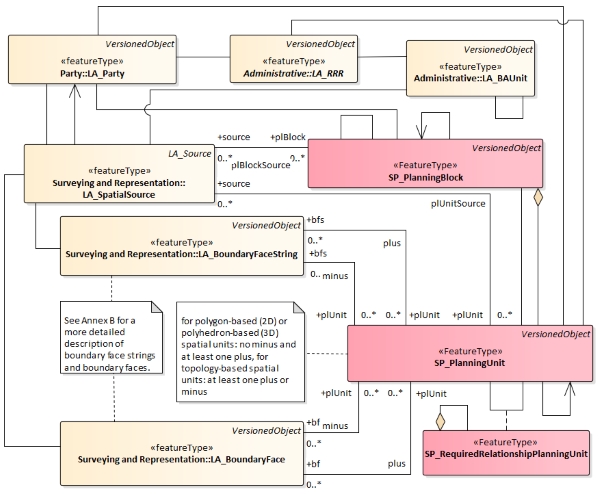
Figure 3 — Classes of Spatial Planning
Information Package and its spatial representation
Both SP_PlanningBlock and SP_PlanningUnit classes reuse
LA_BoundaryFace and LA_BoundaryFaceString geometry to represent sectoral
policies integration through spatial planning processes (Fig 3). An
instance of the class LA_BoundaryFaceString accommodates a boundary face
string of spatial planning area. LA_BoundaryFaceString is also
associated with class LA_Point.
A document related to the geometry of spatial planning is portrayed
via class LA_SpatialSource. In the case of a location by text, a
boundary face string would not be defined by points. In case of a
boundary face associated with a 3D planning unit, it can be described on
one or more spatial sources; see Figure 4.
To accommodate multidimensional spatial planning, an instance of
class LA_BoundaryFace is a boundary face and VersionedObject accommodate
4D (3D+time) representation for SP_PlanningUnit.
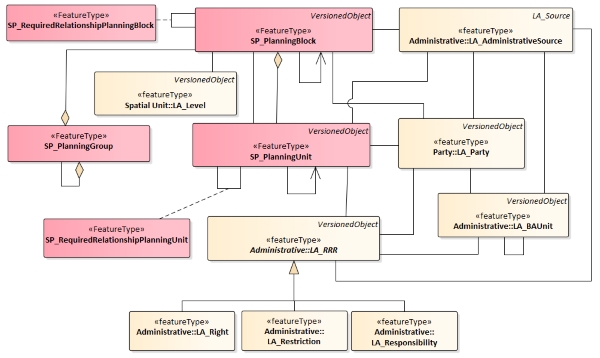
Figure 4 — Classes of Spatial Planning
Information Package and its correlation with LA_RRR
The Spatial Planning Package accommodates RRRs derived from spatial
planning into LA AdministrativeSource and LA_RRR. Administrative aspects
of this package are basic classes of SP_PlanningUnit and
SP_PlanningBlock (see Figure 4). LA_AdministrativeSource facilitates the
foundation for rights, restrictions, and responsibilities derived from
the spatial planning process. Class SP_RequiredRelationshipPlanningUnit
allows for creating instances of relationships between SP_PlanningUnits.
The RequiredRelationships classes are similar to the BAUnit class, which
can be legal, temporal, or of a spatial nature. An instance of the class
SP_PlanningUnit registers a zoning unit which may contain RRRs derived
from spatial planning processes. These classes are based on an
administrative source; an instance of class SP_AdministrativeSource (see
Figure 4). There is a unique combination between an instance of
LA_Party, an instance of a subclass of LA_RRR, and an instance of
SP_PlanningUnit to preserve the particularity of RRRs for each
SP_PlanningUnit. Both SP_PlanningUnit and SP_AdministrativeSource are
related to LA_RRR representing the integration of the RRRs derived from
spatial planning and land administration.
5.4 Refined Survey Model
LADM refers to Observations and Measurement Standard (ISO, 2011)
which is essentially a survey model, though a very generic and with
limited capabilities one. Therefore, to facilitate a comprehensive
spatial description, which incorporates the diverse elements of the
survey component, specifically: different data acquisition and
processing techniques, spatial data formats, types of survey documents
and the actions which can be applied to a spatial unit, a Refined Survey
Model (RSM) is required. The purpose of this model is to improve work
flows of land management organizations where they exist and to propose a
systematic, structured approach to linking spatial sources with their
counterpart spatial units which in turn contributes to a transparent and
accessible survey data (Soffers, 2017).
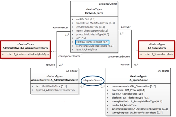
Figure 5 — Extended LA_SpatialSource
Class
In order to form a Refined Survey Model, an extended LA_SpatialSource
class is suggested (Figure 5) including several new attributes and
corresponding Code Lists. In addition, a new optional association class
was created to link LA_Party and LA_SpatialSource/
LA_AdministrativeSource. The purpose of these association classes is to
denote the different roles of a survey executor and administrative
party/ies that are not directly portrayed by the “role” attribute in the
LA_Party class.
Furthermore, a new concept of an “Integrated Source” is suggested
which is modeled as an association between the Administrative and the
Spatial source classes. Different source types are represented via
assignment of multiplicity, where “0” represents a case of a pure
Administrative or Spatial source, whereas “1” illustrates a situation
where a document contains both types of information.
Figure 6 represents the complete Refined Survey Model, which includes
both 2D and 3D cases. In the interest of explicitly represent the
relation between LA_SpatialSource and LA_SpatialUnit - that exists in
the real-world scenario however hasn’t been depicted in the model in
Edition I - an association class “LA_SurveyRelation” is proposed.
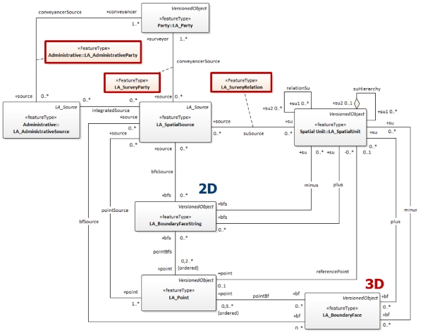
Figure 6 — Refined Survey Model
5.5 3D Spatial Profiles
At the current edition of LADM, the Spatial Unit Package and the
Spatial Representation and Survey sub-packages allow a number of
possible representations of spatial units in 2D, 3D or mixed dimension
(integrated 2D and 3D), ranging from “text based” spatial unit to the
“topology based” level encoding, providing a framework for
categorization of spatial units recorded in cadastral or other land
administration organizations systems. For 2D spatial units five spatial
representations are supported, while there is also one spatial profile
for 3D spatial units (Annex E ISO 19152, 2012).
The initial classification of 3D spatial units was provided by
Thompson et al. (2015) and forms the starting point for further
investigation. These were named as: “2D Spatial Units”, “Above / Below a
Depth or Height” (semi-open spatial units), “Polygonal Slice”,
“Single-Valued Stepped Slice”, “Multi-Valued stepped Slice”, and
“General 3D Parcels”. These categories have been used in discussing
approaches to representing and storing spatial unit information.
The defined spatial units’ categories (FIG, 2018b; Thompson et al.,
2016) are listed below in an order of growing complexity (Kalogianni et
al., 2018) and presented in Figure 7:
- 2D spatial unit: completely defined by the 2D location of
points along its boundary.
- 3D spatial unit: defined by a set of bounding faces, which are
themselves defined by a set of 3D points and an interpretation. The
following subcategories are defined:
- Semi-open spatial unit: defined by a 2D shape with one
horizontal surface (upper or lower surface) – e.g. “to the depth of
…meters”.
- Polygonal slice spatial unit: defined by 2D shape with
horizontal bounded surfaces (upper and lower surface), it is the
most common form of closed 3D spatial unit.
- For both categories, the following subcategories (depending on the
nature of the surface definition) are defined:
- Above/below an elevation: the surface is defined by a horizontal
flat plane at a height above/below a datum.
- Above/below a surface parallel to the local ground surface, and
a defined distance above/below it.
- Single-valued stepped spatial unit: defined by only horizontal and
vertical boundaries, but non self-overlapping in z.
- Multi-valued stepped spatial unit: defined by a set of boundary
faces, all of which are all either horizontal or vertical, without a
restriction of the volume to being single valued in z. This allows
volumes with “caves” or “tunnels” in the wall.
- General 3D spatial unit: the “catch-all” category of spatial units,
which fail to fit in one of the above categories. It is defined in part
by boundaries other than horizontal and vertical and thus at its
definition at least one boundary should be defined by one
non-horizontal, or non-vertical face. This category may result to a
further categorization as the following boundaries lie in this category:
2-manifold, planar/curved boundaries, open/closed volume, single/multi-
volume. It should be considered whether the sub-categories that will be
created would be mutual exclusive, or would they be independent aspects
and generate multiple categories form their possible combinations.
- Building/construction format spatial unit: legally defined by the
extents of an existing or planned structure that contains/will contain
the unit. In the case that some jurisdictions decide not to record the
geometry at this category, then it can be a 3D spatial unit with a
“text-based” description, while for the rest that do describe the
geometry, this category behaves like other 3D spatial units (usually
polygon slice). The decision to record or not the geometry is purely
local and could be applied to any type of spatial unit.
- Any of these 3D Spatial Units can give rise to a Balance spatial
unit: It can be of any complexity as above but represents the remainder
of a 2D spatial unit (i.e. prism) when all the 3D spatial units defined
within it have been excised. The remainder (inner 3D region) could be of
any complexity, but there are two variants of what this construct means:
˗
- The volume may be a primary interest excised from the 2D spatial
unit (to avoid overlap);
- The volume may define a secondary interest (e.g. lease, where
overlap is allowed), therefore leaving the base spatial unit as a
standard 2D spatial unit.
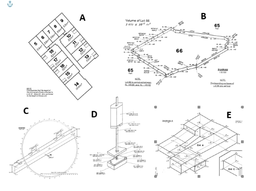
Figure 7 — Subcategories of
spatial unit geometries: A. Building Format spatial units; B. Simple
Slice; C. Single-valued stepped spatial unit; D. Multi-valued stepped
slice; E. General 3D spatial unit (Kalogianni et al., 2018)
In the case where 3D spatial units are modelled by a 3D geometry
collection (polyhedra), within a 2D surface parcel, then the "Balance
space unit" is the unit which comes as a result from prism - (minus)
polyhedron. If the whole 3D domain is modelled as space partition using
a 3D topology structure, then the "Balance space unit" will be a prism
on the outside, with holes or caves made by the 3D geometries.
Based on the categorisation of the 3D spatial units, the following 3D
spatial profiles have been developed and presented in Annex E of ISO/WD1
19152-v2. It is noted that the developed spatial profiles will be used
by all the parts of the LADM Edition II, in case of a multipart
standard.
A Spatial profile for “simple” 3D spatial units, covering polygonal
slice and semi-open spatial units is developed, as presented in Figure
8. It is noted that by leaving “null” the “upper_elevation” and
“lower_elevation” attributes, this profile can be also used to model 2D
spatial units. An issue that was taken into consideration is that one of
the bounded surfaces may be the earth surface. For this reason, the
earth surface has been modelled as “blueprint” for external class and is
related to relative z/height/depth types of representations and/or to 3D
parcel dissemination.
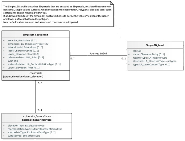
Figure 8 — Proposed spatial profile
for “simple” 3D spatial units and Proposed code lists for external
blueprint class ExtEarthSurface (Kalogianni et al., 2018b)
To cover the case of a building/construction format spatial unit
(mainly referring to polygonal slice spatial units, but all categories
are possible) a spatial profile has been developed, presented in Figure
9.
To represent the reference to a building format, an association with
an external class is added.
It is noted that, this external class needs further, refined
modelling and as a future step it should be modelled considering
approaches of integrating LADM with models encoding the fine detail of
the units, as the integration of LADM with IFC classes; encoding
information through surveying plans (described with LandXML); building
module of CityGML through CityGML-LADM ADE, etc. (Kalogianni et al.,
2019).
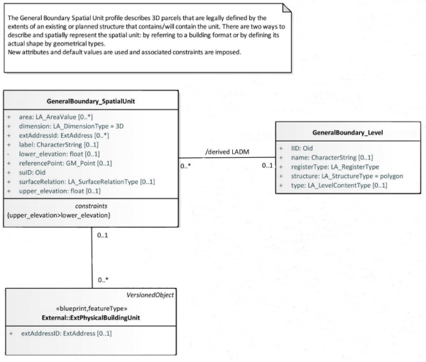
Figure 9 — Proposed spatial profile
for building/construction format spatial units (Kalogianni et al., 2018b)
What is more, a spatial profile for the general spatial unit
has been developed and it aims to cover almost all 3D geometric objects,
however complex. For the general spatial unit, two simplified spatial
profiles are proposed, one in a topological model (Figure 10) and the
other in a polygonal encoding (Figure 11). Those profiles are kept as
simple as possible and should be further explored in relation to
real-world use cases.
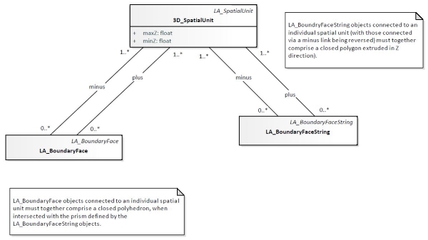
Figure 10 - Spatial profile of a
general spatial unit in a topological model (simplified) (Kalogianni et
al., 2019)
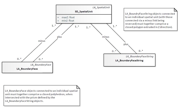
Figure 11 — Spatial profile of a
general spatial unit in a polygonal encoding (simplified) (Kalogianni et
al., 2019)
Last but not least, a spatial profile for balance spatial units has
been developed. This type of spatial units is modelled as the
“remainder” between a normal 2D and 3D parcel, thus they can be
explicitly stored as being the balance of spatial unit when the
sub-units are excised, as depicted in Figure 12. The remainder parcel is
not an independent one, and thus its spatial profile depends on the
spatial profile of the core/basic 3D parcel. It is noted that, at a
conceptual level the association between the two parcels can be derived,
while at the implementation level it can be decided whether it would be
explicitly or implicitly modelled. The association can become explicit
when the 2D parcel is described by simple text (2D text based spatial
profile) or points (2D point based spatial profile).
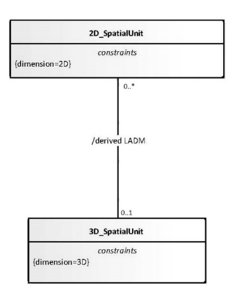
Figure 12 - Spatial profile for the
balanced spatial unit (Kalogianni et al., 2019)
5.6 IndoorGML-LADM Combination
The RRRs inside buildings are needed to support indoor navigation by
managing the access and use of space for each party. The party of the
indoor spaces establishes a relationship with the spaces according to
the type of building and the function of the spaces. The party requires
guidance in some buildings to reach their destination, and, thus,
several navigation models have been developed for this purpose; however,
these models do not distinguish between party types and how that could
affect their accessibility rights. Therefore, the integration of LADM
and IndoorGML allows assigning rights, restrictions, and
responsibilities to each indoor space to determine the accessible spaces
for each type of party. By representing the party types of the indoor
spaces, LADM could establish a relationship between the indoor spaces
and the party. As a result, the navigation process will be more
convenient and more straightforward because the navigation route will
avoid non-accessible spaces based on the rights of the party (Alattas et
al., 2017). The combined use of IndoorGML and LADM covers a broad range
of information classes: (indoor 3D) cell spaces, connectivity, spatial
units/boundaries, (access/use) rights and restrictions,
parties/persons/actors, and groups of them. The integration model of
LADM and IndoorGML is part of a broad hierarchical framework of models
for space subdivision based on RRRs of the party as shown in Figure 13.
Figure 13 — Hierarchical framework of
integration model (Alattas et al., 2018).
IndoorGML is an OGC standard that provides information of the indoor
space and GML syntax for encoding geoinformation for the purpose of
navigation (Alattas et al., 2018). IndoorGML determines a model to
describe the geometry, topology and semantics of the indoor spaces that
are utilized for the components of navigation routes. There are two
categories based on the indoor spatial applications: 1) managing the
building components and facilities, and 2) using the indoor space. The
first category mainly focuses on the architecture elements of the
building such as walls and roofs (discipline is called FM, facility
management). The second category deals with the use and localization
features of the indoor space, which leads to describing spaces such as
rooms, corridors, and constraints elements such as doors. IndoorGML
establishes a framework to determine static or mobile objects (agents)
and provide spatial information services (navigation) by utilizing their
positions in indoor space. IndoorGML represents the spatial character of
the indoor spaces and provides information about their connectivity
[Alattas et al., 2018b]. It has four different type of classes (GML,
IndoorCore, IndoorNavi, and Not implemented) (Alattas et al., 2018). The
combined UML model of IndoorGML and LADM is shown in Figure 14. Note the
main links between these two models is via CellSpace (at the IndoorGML
side) and LA_SpatialUnit/ LA_SpatialSource (at the LADM side).
5.7 Processes Modeling
The LADM conceptual information model is completed by a model
describing the various processes. The LADM processes are organized per
package and cover both data input and output. First, the processes
related to the core LADM packages: Party, Administrative and Spatial
Unit are described; second, the processes of the supplementary packages:
Valuation and Spatial Planning are outlined.
Each process encompasses principle components and forms the legal or
spatial correlation between them. Each element can be cross-connected to
a corresponding LADM class as demonstrated below.
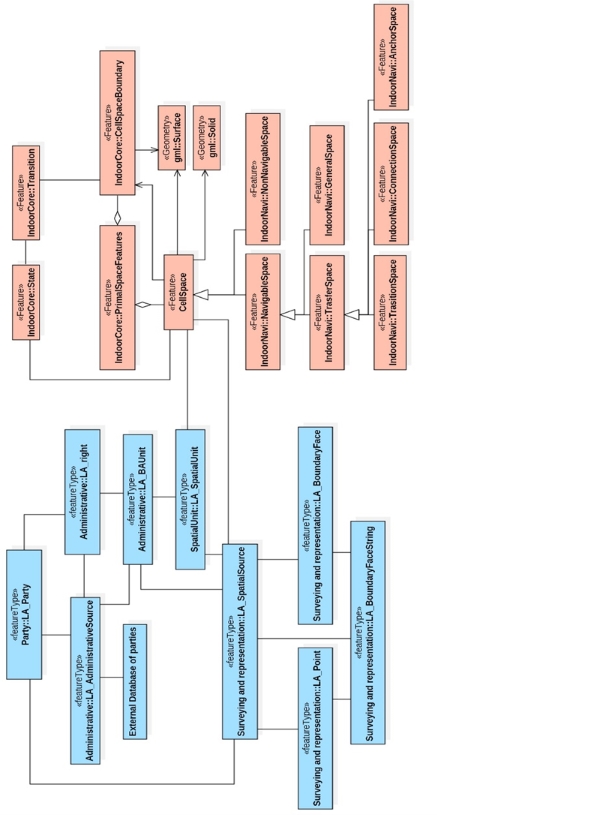
Figure 14 — UML model of LADM-IndoorGML
combined model, the LADM classes are in blue and IndoorGML classes are
in coral IndoorGML
The main goals of processes modeling are:
- Establishing a comprehensive inventory of all land
administration related processes, both fundamental and accessory
processes and proposing a standardized representation methodology
thereof. Processes listed within the inventory include data
acquisition and distribution aspects as well as
The integral components are as follows:
- The interested party or the initiator/s of the process, might
also be referred to as “stakeholder/s”, that may be a person or an
organization, such as: right holder, entrepreneur, municipality,
government or an architect. This element of the process is denoted
by the class LA_Party.
- The executing party – licensed professionals or commoners who
carry out the process, such as: surveyor, volunteer etc. The LADM
class of this element is LA_Party.
- The supervising or the inspectorial authority certified to
approve, audit and/or execute the final step of a certain process.
For example: land registrar, state surveyor, planning or tax
authority which are represented as LA_Party as well.
- The input and the output of a process, may those be legal
(deed/title) or spatial (map) products depending on the type of the
process and can be represented by either LA_Source, both spatial and
administrative, or in some cases integrated sources. Some processes
may include special units as their input/output and hence correspond
to LA_SpatialUnit.
- Format or a procedure of data exchange, submission or
distribution required for the process. For instance, the use of DXF
files for a cadastral map or request for registry form. These may be
depicted by sources attributes such as mediaType.
- Legal basis: the laws, regulations and administrative guidelines
relating to the process, may be presented in LADM by the
LA_AdministratievSource.
- The actions needed to be taken during the process, such as:
selling, recording, surveying etcetera.
- Timeframe, it is a common practice for a timeframe for each
specific part of a particular process to be set by law or in a case
of lack of regulatory basis to be agreed upon by all the parties
involved.
- Restrictions or constraints which are characteristic of a given
process, may be formed as constrains in the LADM model.
The general methodology for process modelling is of a hierarchical
nature. The suggested framework consists of 4 steps – levels:
- Level 1 – Identification of all the actors/elements involved in
a process according to the specified elements. Note: the actors
and/or the elements might differ from country to country subject to
enforced laws and accepted procedures.
- Level 2 – Identification of process phases, in other words
groups or sub-processes relating to a certain topic and provision of
generic descriptions.
- Level 3 – Identification of basic activities.
- Level 4 – Building of a model.
The first two levels may be depicted by use case diagrams, whereas
Levels 3 and 4 can be presented via activity and/or sequence diagrams.
It should be noted here that Canada proposes to revise the definition
of "spatial unit" to include points and lines and advocates for an
approach by spatial profiles. This is included already in LADM – but if
there is a need to make this more explicit then this is an improvement.
The current (2012) Annex E defines the following spatial profiles: a
‘sketch based’, ‘point based’, ‘text based’, ‘unstructured (line)
based’, ‘polygon based’, ‘topological based’ spatial unit (in 2D and 3D
space).
5.8 Explicit Inclusion of Deeds Registration
SCC Canada proposes that in the revision of LADM a model and
documentation for the Deed registration systems are explicitly included.
There really seems to be a need for discussion on this issue. Canada
concludes that “the actual model does not support existing land
information systems centred on Deed”. This conclusion conflicts with the
reality where countries with deeds registration, as Columbia, are
implementing the LADM. Neighbour countries (also with deed systems) as
Ecuador, Peru and Bolivia follow these developments. If agreed, Deed
Registration will be included explicitly. Furthermore, Title
Registration can be explicitly included, as well as other types of
registration – see the example from China as presented in Maribor or
STDM based approaches (integrated land administration without fragmented
institutional responsibilities). Therefore, not exclusive to Western
oriented systems. Regardless, it can be noted that both Deed and Title
registration are completely supported in Edition I. See the LADM Annex N
on History and Dynamic Aspects and also the references to “deed” under
LA_Source and LA_AdministrativeSource. Please note that also systems
with only occupation rights and ownership under the state are supported.
5.9 Country Profiles
RMIT University, Australia proposes guidelines regarding development
of country profiles to be developed to assist in LADM implementation
around the world. In the first instance, this could target only tenure
arrangements (especially if LADMv2 is much broader).
It is noted that a methodology for the development of LADM-based
country profiles, considering both technical and non-technical aspects,
is already available and the initial text can be found in ANNEX D.1
‘‘Methodology for developing a country profile’’ of ISO/WD1 19152-v2(E).
The methodology is based on the afore-mentioned research and builds on
the existing technical knowledge and experience with LADM
implementation, considering both technical and non-technical aspects
that is needed to be reflected in order a jurisdiction to adopt LADM, as
a step towards actual implementation.
Certification for the level of compliance with LADM should be
discussed and decided for software developers that develop LADM-based
solutions, as well as for developed country profiles.
During the ISO TC211 meeting in Maribor, it was discussed that it is
possible to create an inventory to store, maintain and update the
developed LADM country profiles.
6. DRAFT NEW LADM SCOPE
Given all developments and requirements a draft version of the scope
of LADM Edition II can be presented now. New contents is marked in
yellow; contents to be deleted in red.
This International Standard:
- defines a reference Land Administration Domain Model (LADM)
covering basic information-related components of Land Administration
(including those over water and land, and elements above and below the
surface of the earth);
- provides an abstract, conceptual model with five packages and
one subpackage related to:
- parties (people and organizations)
- basic administrative units, rights, responsibilities, and
restrictions (ownership rights, etc.);
- spatial units (parcels, and the legal space of buildings and
utility networks) with a subpackage on surveying and spatial
representation (geometry and topology);
- valuation (valuation units, buidlings, mass appraisal); and:
- spatial planning (planning block, planning unit).
- provides terminology for land administration, based on various
national and international systems, that is as simple as possible in
order to be useful in practice. The terminology allows a shared
description of different formal or informal practices and procedures in
various jurisdictions;
- provides a platform for indicators to be used for comparison
and monitoring;
- provides an approach to modelling land administration
processes;
- provides in various encodings (CityGML, InfraGML, RDF,
INTERLIS, BIM/IFC, GeoJSON) the technical models covering scope of
conceptual model
- provides a basis for national and regional profiles; and
- enables the combining of land administration information from
different sources in a coherent manner.
The following is outside the scope of this International Standard:
- interference with (national) land administration laws that may
have any legal implications; and
- construction of external databases with party data, address
data, land cover data, physical utility network data, archive data
and taxation data. However, the LADM provides stereotype classes for
these data sets to indicate which data set elements the LADM expects
from these external sources, if available.
7. ACTIONS
- Agreement on the publication of the second Edition of LADM organized
into multiple parts (either as multiple coherent packages in one
standard as available in draft or every part in separate standard).
Working Titles of the packages (or parts) are as follows:
- Part 1 - Land Administration Fundamentals
- Part 2 - Land Tenure or Land Registration or Land Interests
- Part 3 - Marine Space or Marine Geo-Regulation
- Part 4 - Land Valuation
- Part 5 - Spatial Planning
- Part 6 – Implementations
- Each part will be a separate standard and every part requires a
submission of a formal “New Working Item Proposal” (NWIP). These 5 or 6
NWIPs may be submitted by various stakeholders, or in cooperation
between them, namely: UN GGIM, WB, FIG, IHO, RICS, EuroSDR, EU JRC,
CINDER, ELRA, TEGoVA, IVSC, IAAO – others or combinations and depending
on the contents. Therefore, contacts have to be established between
those bodies. FIG remains the key liaison with its commissions on
spatial planning, valuation and cadastre and land management – combined
with FIG’s Standards Network.
- Linking ISO 9836, activities of TC 307 of ISO with blockchain and
standardisation efforts on Land Use and Land Cover (ISO 19144) are
required.
- Attention must be paid to Simple Schemas, Country Profiles,
Certification and (meaningful, structured and versioned) Code List
values and their implementation.
- The developments of LADM will be presented at the Meeting of the
Domain Working Group Land Administration of the Open Geospatial
Consortium in Leuven on June 26th, 2019 and to the LADM 2019 workshop
(1-3 October 2019, Kuala Lumpur, Malaysia). This latter workshop is the
next source and inspiration for the development and evaluation of the
new parts for the LADM revision.
- Preparations of the Presentation from the LADM Project Coordinator,
Chris Body, to the UN GGIM, during the 9th Session of the UN committee
of Experts on Global Geospatial Information Management.in August 2019
are ongoing.
- Formal Appointment editors (during the following ISO TC211 meeting in
Japan, December 2019).
- Starting the development of the standard.
8. CONCLUSIONS
The initial needs / goals for LADM v2 were expressed at the UN-GGIM
Expert Group on Land Administration and Management (Delft, The
Netherlands,14-15 of March 2017). During this meeting participants from
member countries and organizations such as UN-SD, UN-HABITAT, UN-ECE,
OGC, FIG, World Bank Group indicated the need for extension in following
directions: extended conceptual model (refined legal modelling,
valuation, Marine, links to BIM, refined survey model/spatial
representations, 3D/4D Cadastre), Technical models (database schema,
exchange formats: CityGML, IndoorGML, InfraLand (InfraGML), LandXML, and
(Geo)BIM) and standardization beyond models (Organization (best
practices), Legal/financial aspects, OpenCadastre approach (crowd
sourcing), Workflow modelling, Blockchain and ledger technologies).
These requirements were further addressed at two LADM workshops
(2017, Delft and 2018 Zagreb) and during special meetings at the World
Bank Land and Poverty Congress in 2017 and 2018. A very wide range of
groups should benefit from LADM Edition II: citizens, surveyors,
registrars, valuers, conveyors, hydrographers, developing cooperation,
national cadastre and registry organisations, software development
companies (open and closed source), UN GGIM, IHO, OGC, etc.. This was
confirmed by the ISO TC211 formal voting (ending on 5 March 2018) on the
systematic review of ISO 19152:2012: the majority of the ISO/TC211
P-members expressed their wish for the revision and included a number of
suggestions in line with the above mentioned functionality. (ISO, 2018).
While the term ‘Land Administration’ tends to relate to tenure,
value, use and development functions of land, LADM’s emphasis on tenure,
or information about Rights, Restrictions and Responsibilities (RRRs),
is fundamental and this should be retained as a priority and focal point
of the ontology. However, perhaps clarification can be provided to
address nomenclature (as suggested by RMIT University). LA_Party,
LA_RRR, LA_BAUnit and LA_SpatialUnit remain the proposed core classes in
LADM Edition II. The Social Tenure Domain Model should be related here.
In addition, LADM Edition II is expected to also support land valuation
information and planned land use information (supporting development).
This makes the coverage of ‘Land Administration’ more complete by LADM
Edition II, which is very important if the aim is to harmonize the
models form these very related (sub)domains of land administration.
The proposed LADM Edition II brings more complete support land
management (also spatial planning, valuation, marine cadastre) and is
closer to implementation (also technical models and processes).
A New Working Item Proposal for the development of a second Edition
of the Land Administration Domain Model has been submitted by the FIG to
the ISO Technical Committee 211 on Geographic Information. This requires
re submission of NWIPs per part.
REFERENCES
- Alattas, A., Zlatanova, S., van Oosterom, P.J.M. and Li, K.
(2018) Improved and More Complete Conceptual Model for the Revision
of IndoorGML. GIScience.
http://drops.dagstuhl.de/opus/volltexte/2018/9349/pdf/LIPIcs-GISCIENCE-2018-21.pdf
- Alattas, A., Zlatanova, S., Van Oosterom, P.J.M.,
Chatzinikolaou, E., Lemmen, C.H.J. and Li, K.-J. (2017) Supporting
Indoor Navigation Using Access Rights to Spaces Based on Combined
Use of IndoorGML and LADM Models. ISPRS International Journal of
Geo-Information, 6(12), 384. doi:10.3390/ijgi6120384.
https://ris.utwente.nl/ws/portalfiles/portal/30993616/Alattas2017supporting.pdf
- Almy, R. (2014) Valuation and Assessment of Immovable Property.
OECD Working Papers on Fiscal Federalism.
https://pdfs.semanticscholar.org/876a/f133507313506c076c99da8d3aafc67f4e27.pdf
- Bird, R. M. and Slack, E. (2002) Land and Property Taxation: A
Review. World Bank, Washington, DC.
https://pdfs.semanticscholar.org/7a04/d879c32871b93ddfee7f2c1984ce01c97201.pdf
- Çağdaş, V., Kara, A., Işikdağ, U., Van Oosterom, P.J.M., Lemmen,
C.H.J. and Stubkjaer, E. (2017) A Knowledge Organization System for
the Development of an ISO 19152:2012 LADM Valuation Module. In:
Proceedings of FIG working week 2017, 29 May - 2 June 2017,
Helsinki, Finland.
https://www.fig.net/resources/proceedings/fig_proceedings/fig2017/papers/ts08i/TS08I_cagdas_kara_et_al_8904_abs.pdf
- Çağdaş, V., Kara, A., Van Oosterom, P.J.M., Lemmen, C.H.J.,
Isikdag, U., Kathmann, R. and Stubkjaer, E. (2016) An initial design
of ISO 19152:2012 LADM based valuation and taxation data model. In:
Proceedings of the 11th 3D Geoinfo conference, 20-21 October 2016,
Athens, Greece. Peer reviewed Annals, Volume IV-2/W1 / edited by E.
Dimopoulou and P. van Oosterom. ISPRS, 2016. ISSN: 2194-9050.
https://www.isprs-ann-photogramm-remote-sens-spatial-inf-sci.net/IV-2-W1/145/2016/isprs-annals-IV-2-W1-145-2016.pdf
- Čerba, O. (2010). Conceptual Data Models For Selected Themes.
Plan4All. ECP-2008-GEO-318007.
https://www.slideshare.net/plan4all/d42-conceptual-data-models-for-selected-themes
- Enemark, S. (2004). Building land information policies. In
Proceedings of Special Forum on Building Land Information Policies
in the Americas. Aguascalientes, Mexico (Vol. 26, No. 27.10, p.
2004).
https://www.fig.net/resources/proceedings/2004/mexico/papers_eng/ts2_enemark_eng.pdf
- FAO (2012) Voluntary Guidelines on the Responsible Governance of
Tenure of Land, Fisheries and Forests in the Context of Food
Security. FAO, Rome, Italy.
http://www.fao.org/3/a-i2801e.pdf
- FAO (2017). A technical guide on valuing land tenure rights in
line with the Voluntary Guidelines on the Responsible Governance of
Tenure of Land, Fisheries and Forests in the Context of National
Food Security, Governance of Tenure Technical Guide No. 11, Rome,
2017; ISBN 978-92-5-130069-5.
http://www.fao.org/3/a-I8252e.pdf
- FIG (1995). The FIG statement on the cadastre. International
Federation of Surveyors.
- FIG (2012) Spatially Enabled Society. Joint publication of
FIG-Task Force on Spatially Enabled Society in cooperation with GSDI
Association and with the support of Working Group 3 of the PCGIAP.
ISBN 978-87-90907-97-6.
https://www.fig.net/resources/publications/figpub/pub11/figpub11.asp
- FIG (2017) Documentation of the 6th Land Administration Domain
Workshop, Delft, The Netherlands.
http://isoladm.org/LADM2017Workshop
- FIG (2018a) Proceedings 7th Land Administration Domain Workshop,
Zagreb, Croatia, 11-13 April 2018. Editors: Christiaan Lemmen, Peter
van Oosterom & Elfriede Fendel. ISBN 978-87-92853-69-1.
International Federation of Surveyors FIG, Copenhagen, Denmark.
http://isoladm.org//LADM2018Workshop
- FIG (2018b) Best Practices 3D Cadastres. Extended version.
Editor: Peter van Oosterom. ISBN 978-87-92853-64-6. International
Federation of Surveyors FIG, Copenhagen, Denmark
http://www.fig.net/news/news_2018/04_FIGPub_3DCad.asp
https://www.fig.net/resources/publications/figpub/FIG_3DCad/FIG_3DCad-final.pdf
- FIG/GLTN (2010) The Social Tenure Domain Model. FIG Publication
no 52. ISBN 978-87-90907-83-9.
https://www.fig.net/resources/publications/figpub/pub52/figpub52.asp
- FIG/World Bank (2014) Fit-for-purpose land administration:
Copenhagen, International Federation of Surveyors FIG, 2014. FIG
Publication 60, ISBN 978-87-92853-11-0.
- INSPIRE (2014). INSPIRE feature concept dictionary. INSPIRE
Registry. INSPIRE Reference Platform.
http://inspire.ec.europa.eu/featureconcept
- ISO (2011) ISO 19156:2011, Geographic information — Observations
and measurements. International Organization for Standardization
(ISO). Geneva, Switzerland.
- ISO (2012). ISO 19152:2012. Geographic information – Land
Administration Domain Model (LADM). International Organization for
Standardization (ISO). Geneva, Switzerland.
https://www.iso.org/standard/51206.html
- ISO (2018). Result of voting on Systematic review ISO
19152:2012, Geographic information -- Land Administration Domain
Model (LADM), ISO/TC 211 N 4812, 22 May 2018.
- Kalogianni, E., Dimopoulou, E., Thompson R., Lemmen, C.H.J. and
van Oosterom, P.J.M. (2018). Investigating 3D spatial unit’s as
basis for refined 3D spatial profiles in the context of LADM
revision, 6th International FIG 3D Cadastre Workshop 2018, 177-200.
http://www.gdmc.nl/3DCadastres/workshop2018/programme/Workshop2018_10.pdf
- Kalogianni E., Dimopoulou, E., Thompson R., Lemmen, C.H.J., Ying
S. and van Oosterom, P.J.M. (2019). Development of 3D spatial
profiles to support the full lifecycle of 3D objects. Special Issue
'3D Land Administration for 3D Land Uses', Land Use Policy 2019 (to
be published).
- Kara A., Cagdas V., Lemmen C., Işikdag U., van Oosterom P.,
Stubkjær E. (2018) Supporting Fiscal Aspect of Land Administration
through a LADM-based Valuation Information Model. 2018 World Bank
Conference on Land and Poverty, The World Bank - Washington DC,
March 19-23, 2018.
file:///C:/Users/LemmenChrit/Downloads/07-08-Kara-439_paper.pdf
- Kaufmann, J. and Steudler, D., (1998). Cadastre 2014. A vision
for a future cadastral system. FIG XXI International Congress.
Brighton, United Kingdom.
https://www.fig.net/resources/publications/figpub/cadastre2014/translation/c2014-english.pdf
- Lemmen, C.H.J. (2012) A domain model for land administration.
Delft, Technical University Delft (TUD), University of Twente
Faculty of Geo-Information and Earth Observation (ITC), 2012. ITC
Dissertation 210, ISBN 978-90-77029-31-2.
file:///C:/Users/LemmenChrit/Downloads/Christiaan_Lemmen_Dissertatiion_Final.pdf
- Lemmen, C.H.J., Van Oosterom, P.J.M. and Bennett, R.M. (2015)
The land administration domain model. In: Land use policy, 49(2015)
pp. 535-545.
https://www.sciencedirect.com/science/article/pii/S0264837715000174
- Lemmen, C.H.J., van Oosterom, P.J.M. and Kalantari, M. (2018)
Towards a New Working Item Proposal for Edition II of LADM. In:
Proceedings of the 7th International FIG Workshop on the Land
Administration Domain Model 11-13 April 2018, Zagreb, Croatia,
International Federation of Surveyors, Copenhagen, Denmark. 331 –
354
http://isoladm.org/LADM2018Workshop/21-22_LADM_2018.pdf
- McCluskey, W.J. (1999) Comparative Property Tax Systems: An
International Comparative Review. Aldershot, UK: Avebury Publishing
Limited.
- Murgante, B., Di Donato, P., Berardi, L., Salvemini, M., & Vico,
F. (2011, June). Plan4all: European Network of Best Practices for
Interoperability of Spatial Planning Information. In: Computational
Science and Its Applications (ICCSA), 2011 International Conference
on (pp. 286-289). IEEE.
- OGC (2016). OGC Land and Infrastructure Conceptual Model
Standard (LandInfra). (Version 1.0, Publication Date: 2016-12-20),
Editor: Paul Scarponcini, Contributors: HansChristoph Gruler
(Survey), Erik Stubkjær (Land), Peter Axelsson, Lars Wikstrom
(Rail).
- OGC (2019). OGC White Paper on Land Administration. Editors:
Christiaan Lemmen, Peter van Oosterom, Mohsen Kalantari, Eva-Maria
Unger and Cornelis de Zeeuw. External identifier of this OGC®
document:
http://www.opengis.net/doc/wp/land-admin Internal
reference number of this OGC® document: 18-008r1. Copyright © 2019
Open Geospatial Consortium.
https://docs.opengeospatial.org/wp/18-008r1/18-008r1.html
- Paasch, J.M., van Oosterom, P.J.M., Lemmen, C.H.J. and Paulsson,
J. (2015) Further modelling of LADM's rights, restrictions and
responsibilities (RRRs). In: Land use policy, 49(2015) pp. 680-689.
- Scarponcini, P. (2017). Code List Manifesto. OGC Pending
document, 17-050r1, 2017-09-04. Stubkjær, E., Scarponcini, P.
(2017). Harmonization of standards - The ISO 19152:2012 LADM-family.
OGC March 2017 Technical and Planning Committee Meeting - Delft, the
Netherlands. Land Admin DWG, 2017-03-21.
- Soffers, P. (2017). Designing an integrated future data model
for survey data and cadastral mapping. MSc Thesis in geomatics for
the build Environment. Delft University of Technology.
http://www.gdmc.nl/publications/2017/PieterMScThesis.pdf
- Stubkjær, E., Paasch, J.M., Çağdaş, V., van Oosterom, P.J.M.,
Simmons, S., Paulsson, J. and Lemmen, C.H.J. (2018). International
Code List Management – The Case of Land Administration. In:
Proceedings of the 7th International FIG Workshop on the Land
Administration Domain Model 11-13 April 2018, Zagreb, Croatia,
International Federation of Surveyors, Copenhagen, Denmark. Pages
223 – 244
https://wiki.tudelft.nl/pub/Research/ISO19152/LADM2018Workshop/15-05_LADM_2018.pdf
- Teo, C. and Lemmen, C.H.J. (2013). The LADM and the continuum of
land rights. In: Proceedings of the 5th Land Administration Domain
Model workshop, 24-25 September 2013, Kuala Lumpur, Malaysia.
https://www.fig.net/resources/proceedings/2013/2013_ladm/00.pdf
- Thompson, R., van Oosterom, P.J.M., Karki, S. and Cowie, B.
(2015) A Taxonomy of Spatial Units in a Mixed 2D and 3D Cadastral
Database. FIG Working Week 2015.
file:///C:/Users/LemmenChrit/Downloads/322668.pdf
- Thompson, R., van Oosterom, P.J.M., Soon, K.H. and Priebbenow,
R. (2016) A Conceptual Model supporting a range of 3D parcel
representations through all stages: Data Capture, Transfer and
Storage. In: FIG Working Week 2016 – Recovery from Disaster,
Christchurch, New Zealand, May 2-6, 2016.
https://www.fig.net/resources/proceedings/2016/2016_3dcadastre/3Dcad_2016_02.pdf.pdf
- UN (2017). A/RES/71/256 New Urban Agenda. ISBN:
978-92-1-132731-1.
http://habitat3.org/the-new-urban-agenda/
- UN ECOSOC and African Union, (2016). Facing the Challenges of
Land Monitoring in the Framework and Guidelines on Land Policy in
Africa – Towards Agenda 2063 and the 2030 Agenda for Sustainable
Development.
https://repository.uneca.org/handle/10855/23503
- UN-GGIM (2019). Framework for Effective Land Administration – A
reference for developing, reforming, renewing, strengthening or
modernizing land administration and management systems. Expert Group
on Land Administration and Management United Nations Committee of
Experts on Global Geospatial Information Management (UN-GGIM) July
2019
http://ggim.un.org/meetings/GGIM-committee/9th-Session/documents/E_C.20_2020_10_Add_1_LAM_background.pdf
- UN Habitat/GLTN (2017) Sourcebook for Operationalisation of
Global Land Indicators. Global Land Indicators Initiative (GLII)
Working Paper Number 4. Nairobi.
http://mirror.gltn.net/index.php/land-tools/gltn-land-tools/global-land-indicators-initiative-glii
- UN-Habitat/GLTN/Kadaster (2016) Fit-for-purpose land
administration: guiding principles for country implementation:
e-book. Nairobi, United Nations Human Settlements Programme
(UN-HABITAT), 2016.
https://gltn.net/download/fit-for-purpose-land-administration-guiding-principles-for-country-implementation/
- UN-HABITAT, (2008) Secure land rights for all. Nairobi, Kenya,
United Nations Human Settlements Programme: 40 p.
file:///C:/Users/LemmenChrit/Downloads/2488_alt%20(2).pdf
- Van Oosterom, P. and Lemmen, C.H.J.
(2015) The Land Administration Domain Model (LADM): Motivation,
standardisation, application and further development. In: Land use
policy, 49(2015) pp. 527-534.
BIOGRAPHICAL NOTES
Christiaan Lemmen is full Professor Land Information
Modeling at the Faculty of GeoInformation Science and Earth Observation
of the University of Twente in the Netherlands. His other main job is as
Senior Geodetic Advisor at Kadaster International, the international
branch of the Netherlands Cadastre, Land Registry and Mapping Agency. He
is director of the OICRF, the International Office of Cadastre and Land
Records, one of the permanent institutions of the International
Federation of Surveyors (FIG).
Peter van Oosterom obtained an MSc in Technical
Computer Science in 1985 from Delft University of Technology, the
Netherlands. In 1990 he received a PhD from Leiden University. He is
professor at the Delft University of Technology, and head of the ‘GIS
Technology’ Section, Department OTB, Faculty of Architecture and the
Built Environment, Delft University of Technology, the Netherlands. He
is the current chair of the FIG Working Group on ‘3D Cadastres’.
Abdullah Kara holds BSc in Geomatics Engineering
from Istanbul Technical University and MSc degree in Geomatics Programme
of Yıldız Technical University (YTU). He worked as an engineer in the
Development of Geographical Data Standards for Turkey National GIS
Infrastructure. He is a PhD candidate in YTU. He visitied GIS Technology
Section, Department OTB, Delft University of Technology as a guest
researcher in 2018.
Eftychia Kalogianni is a PhD candidate in GIS
Technology’ Section at the Faculty of Architecture and the Built
Environment, Delft University of Technology in the Netherlands. Her PhD
research topic is about adopting a holistic approach to treat 3D
Cadastres within the spatial development chain. She holds a MSc in
Geoinformatics from NTUA and a MSc in Geomatics from TU Delft. In 2012,
she received a diploma in Rural and Surveying Engineering from National
Technical University of Athens. Since 2015, she works at a consulting
engineering company. She is an active member of FIG Young Surveyors
Network.
Anna Shnaidman is a former Geophysical Surveys and
Research Administrator in the Research Division at the Survey of Israel
and a Part-time Lecturer in the Department of Civil Engineering at the
Technion - Israeli Institute of Technology. She received her BSc (2008,
Cum Laude) and MSc (2010) and PhD (2016) degrees in Mapping and
Geo-Information engineering from Israeli Institute of Technology. Dr.
Shnaidman is a Licensed Surveyor as well. Agung Indrajit is a PhD
candidate and teaching assistant in the Faculty of Architecture and the
Built Environment at Delft University of Technology. He is also a member
of the Knowledge Centre Open Data at the same University. His research
interests focus on Spatial Information Infrastructure (SII), Open Data,
and Urban Monitoring. He previously served as Head of Spatial Data
Management in Geospatial Information Agency, Government of Indonesia and
as Spatial Data Manager of Indonesian SII.
Abdullah Alattas is a PhD candidate at the Faculty
of Architecture and the Built Environment, Delft University of
Technology. He is a lecturer in Geomatics, Faculty of Environmental
Design, King Abdulaziz University in Jeddah, Saudi Arabia. In 2014, he
obtained a MSc in Cartography from the international program of the
Technische Universität München, Wien, and Technische Universität
Dresden. In 2008, he received a BSc in architecture from Faculty of
Environmental Design, King Abdulaziz University in Jeddah.
CONTACTS
Christiaan Lemmen
University of Twente , Faculty of Geo-Information Science and Earth
Observation
ITC P.O. Box 217
7500 AE Enschede
Netherlands
Website: www.itc.nl
And:
Cadastre, Land Registry and Mapping Agency – Kadaster International
P.O. Box 9046
7300 GH Apeldoorn
Netherlands
Website: www.kadaster.nl
Peter van Oosterom
Delft University of Technology
Faculty of Architecture and the Built Environment
P.O. Box 5030
2600 GA Delft
Netherlands
Website: www.gdmc.nl
Abdullah Kara Yıldız
Technical University
Department of Surveying Engineering
34210 Esenler
Istanbul
TURKEY
Eftychia Kalogianni
Delft University of Technology Section GIS-technology
Faculty of Architecture and the Built Environment
10 Monis Petraki
11521 Athens
Greece
Anna Shnaidman
Delft University of Technology Section GIS-technology
Faculty of Architecture and the Built Environment
P.O. Box 5030
2600 GA Delft
Netherlands
Agung Indrajit, M.Sc
Delft University of Technology Section GIS-technology
Faculty of Architecture and the Built Environment
P.O. Box 5030
2600 GA Delft
Netherlands
Abdullah Alattas
Delft University of Technology Section GIS-technology
Faculty of Architecture and the Built Environment
P.O. Box 5030
2600 GA Delft
Netherlands


