Article of the Month -
November 2013
|
Boundary Makers: Land Surveying in nineteenth-century,
New Zealand
Professor Giselle BYRNES, Charles Darwin University,
Darwin, Australia
1) Surveyors around the world
are struggling with many current challenges. However, this article gives
you a possibility to reflect about the impact of surveyors through
history in the development and mapping of societies. This paper is a
historical outline of the early land surveyors importance to the history
of New Zealand, as they were among the advance guard of European
settlers to walk the land and assess its potential for future
development. Surveyors around the world are struggling with many current
challenges. However, this article gives you a possibility to reflect
about the impact of surveyors through history in the development and
mapping of societies. The paper is a historical outline of the early
land surveyors importance to the history of New Zealand, as they were
among the advance guard of European settlers to walk the land and assess
its potential for future development. We are pleased to share this paper
with you since FIG Institution for the History of Surveying and
Measurement organises a very special trip, conference and event on
Charting and Mapping the Pacific Paradise of the Pitcairners at
Norfolk Island, (an island half way between Australia and New Zealand),
6-10 July 2014:
Invitation
and
program.
A version of this paper was presented to Celebrating the Past -
Redefining the Future, New Zealand Institute of Surveyors
Conference, University of Otago, Dunedin, New Zealand, 27-30 August
2013. In addition, much of this essay is drawn from Giselle Byrnes,
Boundary Markers: Land Surveying and the Colonisation of New Zealand,
Bridget Williams Books, Wellington, 2001; see also G. Byrnes, ‘Surveying—Maori
and the Land: An Essay in Historical Representation’, New Zealand
Journal of History, vol. 31, no. 1 (1997), pp. 85-98. See also Giselle
Byrnes, ‘Boundary Makers: Land Surveying in 19th Century New Zealand’
in Mick Strack, ed., Survey Marks: A 2013 Celebration, School of
Surveying and the New Zealand Institute of Surveyor, Dunedin, 2013, pp.
7-16.
Key words
Land surveying, colonisation, Maori land, land
settlement
ABSTRACT
Land surveyors in nineteenth-century colonial New
Zealand were located, quite literally, at the ‘cutting edge’ of the
great British imperial project to claim and tame new territories. The
early land surveyors were important actors in this country’s history as
they were among the advance guard of European settlers to walk the land
and assess its potential for future development. Indeed, the landscape
of modern New Zealand testifies to their work through the place-names
they assigned and which are still visible on the map. Moreover, most
colonial land surveyors were aware that they were not ‘first-time
explorers’, but were traversing landscapes that were already known,
named and mapped by the indigenous Maori. In the early period of
organised British settlement, from the 1840s to the 1860s, the land
surveyors’ efforts to claim the land were, therefore, much less an
exercise in possessing the land outright than they were translating the
meaning of land from one cultural framework into another. From the
1860s, however, and especially with the aggressive activities of the
Native Land Court from 1865, the work of the colonial land surveyors
took on a more potent role as Maori land was permanently transitioned
from customary tenure to Crown-derived titles and subsequent private
ownership. This essay briefly considers the colonising efforts of the
early colonial land surveyors in New Zealand during the second half of
the nineteenth-century following the assertion of British sovereignty
1840 and their negotiation of both the cultural and physical boundaries
they encountered during the conduct of laying out the land for future
settlement.
NEW ZEALAND, an isolated archipelago located
some 1500km east of Australia in the south-west Pacific, was one of the
last substantial landmasses to be settled by humans. While the
Polynesian ancestors of the indigenous Maori people arrived on the North
and South Islands over 1000 years ago, the European settlement of New
Zealand occurred much later. Although there was intermittent contact and
trade between Europeans and Maori from the late eighteenth century, it
was not until the 1830s that the British began to assert their presence
in New Zealand, mainly through missionary efforts to ‘convert’ Maori to
Christianity, led by the London-based Church Missionary Society. In
February 1840 the Treaty of Waitangi was signed between the British
Crown and Maori tribes whereby, and despite serious ambiguities between
the intent and meaning of the Maori and English language versions of the
Treaty, the British assumed sovereignty over the country and declared
New Zealand a Crown colony. Massive British and European immigration
immediately ensued and within a decade war over land and issues of
sovereignty broke out. For much of the remainder of the nineteenth
century, the colony of New Zealand was a war-zone with British colonial
forces embroiled in a bitter contest with indigenous Maori for control
of large parts of the country. Eventually, the British declared
themselves victorious and as punishment, much of the remaining land
occupied by Maori tribes was confiscated, following punitive models that
had been applied by the British in subduing the ‘rebel’ Irish clans in
the seventeenth century. In addition, successive New Zealand colonial
governments worked to redefine, control and ultimately transform the
meaning as well as the ownership of Maori land through a series of
complex legislative instruments. In this way, almost all of the Maori
land estate had passed out of indigenous hands by the early years of the
twentieth century. Today, just a small fraction of the original Maori
estate remains in Maori ownership (1).
The colonial land surveyors were critical to this
history of contest and transformation. Located among the vanguard of
European settlers to New Zealand, land surveyors were charged with
creating new outposts of empire that would replicate the values,
attitudes, and aspirations of the Old World. Moreover, the work of the
land surveyors reflects much that is central to the European history of
New Zealand, particularly the transformation, domestication and ‘taming’
of the natural environment. Physically located on the margins of settler
society, the land surveyors occupied a central role in implementing
colonisation on the ground. They were therefore both boundary markers
as well as boundary makers.
SURVEY METHODS AND PRACTICE
The task of the colonial land surveyor was a
significant one. Charged with reining in the wilderness and creating
order and sense in ‘uncharted’ territory, the land surveyors occupied a
peculiar position in the practical implementation of colonial policy.
The lines inscribed by the land surveyors—in maps, drawings and plans as
well as on the land itself—were symbols of power and portents of the
political, social and economic change that was to follow in their wake.
In this way, land surveying was fundamental to the British acquisition
of new territory, and represented, in a very graphic and visible way,
the thrust of the broader colonial project.
Land surveying in colonial New Zealand had its
genesis of course in a much older tradition. In the eighteenth and
nineteenth centuries, the expansion of empires, along with the
consequent need to delineate national boundaries and construct maps of
territorial possession, demanded increasingly accurate methods of land
demarcation and measurement. In addition, the process of enclosure and
the increasing value of private property in rapidly developing urban
centres brought surveying and surveyors into the economic as well as the
political arena. By the middle of the nineteenth century, in Europe at
least, land survey methods comprised a combination of perspectives and
competing practices. While the influence of military techniques
(inherited from the Roman architects of land surveying) remained strong,
this was accompanied in the latter half of the nineteenth century by a
new emphasis on scientific engineering as a direct consequence of
British industrialisation.
TYPES OF SURVEYS
Broadly speaking, land surveys in colonial contexts
fell into two categories. The first involved confirming an already
existing cadastre and provided a retrospective vision of land already
settled; this was the case where the settlement patterns had long been
shaped by history and tradition. The second was concerned with the
future rather than the past; focussed on providing a framework for
future resettlement. This latter method, what might be termed the
'survey of the future', was enthusiastically adopted in New Zealand,
where the land surveyor's chief task was to layer a new spatial order on
the existing landscape. Within this ‘future’ survey, there were two
forms: those where the free selection of land parcels had commenced
prior to actual settlement and those where settlement was consciously
planned in advance. The 'free selection survey' was the most frequent
type of survey in colonial New Zealand, at least in the early years of
organised settlement. This allowed individuals to determine the
boundaries of their own allotment and frequently led to irregular and
odd-shaped parcels of land (along with the consequent administrative
confusion). On the other hand, surveyors who determined the shape of
sections in advance of formal occupation usually laid out a planned
settlement for clients such as individual landowners, a company or the
government. Free selection prior to survey can still be seen in the
design of many rural sections, while the New Zealand Company settlements
(the New Zealand city of New Plymouth, for example) are perhaps the best
examples of the planned settlement surveys. In their work, New Zealand
colonial land surveyors employed instruments which were common to
surveying practice elsewhere, including the theodolite, the
circumferentor or surveyors’ compass, and the prismatic compass (2).
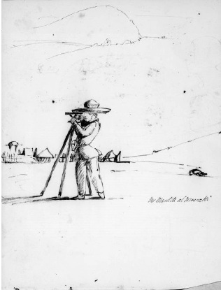
Francis Edward Nairn, ‘Mr Mantell at Moeraki [1848]’, ink on sketchbook.
E333-084-3, Alexander Turnbull Library, National Library of New
Zealand/Te Puna Matarauranga o Aotearoa.
THE COLONIAL LAND SURVEYORS
So who were these men and how might they best be
described? The land surveyors in colonial New Zealand worked in a number
of different capacities. From 1854 surveyors were included on the staff
of the Land Purchase Department (incorporated into the Native Department
in 1885), established to manage the acquisition of Maori land. Until
1862 it was possible to obtain work as a land surveyor without
registration, although surveyors under contract to the Crown to survey
Crown lands (and so-called ‘waste lands’) were required to satisfy the
standards set by the provincial chief surveyors. In the absence of a
standardised system of registration, any person with a minimum knowledge
of surveying could practice with minimal experience or qualifications.
Consequently, many young men turned to surveying as a relatively easy
source of income and adventure.
Following the signing of the Treaty of Waitangi and
the assumption of British sovereignty, increasing numbers of British
settlers arrived in New Zealand. With expectations about the superior
quality and potential of the land, the pressure for land quickly
intensified and the demand for surveyors consequently grew. During the
1840s, tension between the nascent colonial government and the New
Zealand Company over disparate land policies, together with the demands
of Company settlers, who felt cheated of their purchases, stretched the
existing resources of both the New Zealand Company and Crown survey
services. Sons of missionaries and traders, many of whom were educated
in mission schools and were fluent in the Maori language, were readily
recruited as surveyors. It is worth noting that their intimate knowledge
of Maori culture and language proved invaluable not only in negotiating
the survey, but also in facilitating the purchase of much of the Maori
land estate. With the further influx of settlers in the 1850s and 1860s,
the colonial government increasingly looked to the immigrant population
for additional survey staff.
Most but by no means all of the early surveyors were
born in England and made New Zealand their adoptive home. Some came from
Scotland and Ireland, while others came from further afield,
particularly central Europe. A large number of land surveyors had spent
time in the Australian colonies before arriving in New Zealand; indeed,
most of the early surveyors who have left records had travelled
extensively before arriving in the colony. Some had left established
careers to immigrate and brought experience with them, while others were
young men who chose to ‘cut their teeth’ in developing a surveying
career in New Zealand. Robert Park and John Rochfort, for instance, were
trained in engineering; Charles Heaphy initially trained as a
draughtsman; and Theophilus Heale, later chief surveyor and inspector of
surveys, was educated as a classical scholar, mathematician and
navigator. Some—Charles Heaphy, Samuel Brees and John Buchanan, for
instance—were highly accomplished artists, while others had trained as
draughtsmen and drew on these technical skills in the course of their
surveying fieldwork. Others became active in political roles, at both
the provincial and national level. Frederick Carrington, for example,
was a provincial superintendent and a Member of the New Zealand
Parliament. Land surveying was often a natural choice of occupation for
those young male settlers who could make use of their skills in a
particularly practical fashion. In addition, the colonial land surveyors
were often men of learning and intellectual ability, with interests in
poetry, ethnology, philology and geology. It would be fair to say too
that land surveying, due to its physical rigors, typically attracted
young men with a keen sense of adventure and an abundance of energy. For
many young men, a surveying career also promised the challenge of
working on the colonial frontier (3).
Two descriptions of the colonial land surveyors
vividly depict their appearance and countenance. The first is the young
Edward Jerningham Wakefield's colourful impression of meeting a group of
survey cadets in 1845 and is worth citing at some length. ‘I met two or
three of these [cadets] on the Porirua road’, Wakefield recalled, 'with
labourers and theodolites and other baggage, starting for the Manawatu
[a region of New Zealand]. I remember laughing at their dandified
appearance and wondering what new arrivals had thus suddenly taken to
the bush’. Wakefield was amused (and possibly irritated) by what he saw
as their youthful exuberance and highly affected appearance. 'Everything
about them was so obviously new; their guns just out of their cases
fastened across tight-fitting shooting jackets by patent leather belts;
their forage caps of superfine cloth; and their white collars relieved
by new black silk neckerchiefs. … Some positively walked with gloves and
dandy-cut trousers,' he continued, 'and, to Crown all, their faces shone
with soap. There had been a little rain the night before and, having
only got about two miles from the town, they were still picking their
way and stepping carefully over the muddy places.' Wakefield, with
first-hand experience of the hardships of colonial life, knew these
efforts at cleanliness and respectability would be short-lived. 'I sat
down on the stump of a tree', he concluded, 'and vastly enjoyed the
cockney procession; wondering how long their neat appearance and
fastidious steps would last.' (4)
John Turnbull Thomson's description of the colonial
surveyor provided a startlingly contrasting picture that emphasised the
egalitarian nature of life on a survey team. 'The Colonial Surveyor', he
wrote, ' ... is clothed in fustian trousers and blue shirt, Panama hat,
and stout hob-nailed shoes. He is not known from his chainman. If he
smokes, it is … through a "cutty" pipe, and he puffs at that
energetically.' Thomson's surveyor was not only resourceful, but a
jack-of-all-trades: 'He has a hundred things about him; knives, needles,
telescopes, matches, paper, ink, thread and buttons; these are stowed
away in all corners of his dress; and then his "swag" contains his tent,
blankets, and [a] change of clothes.' Thomson’s surveyor was also a man
of the land. 'These [items] with his theodolite he carries on his back,'
Thomson went on to say, 'and walks away through bogs, "creeks", and
scrubs, at the rate of 3 miles an hour. He cleans his shoes once a month
with mutton drippings, and he lives on "damper", salt junk and oceans of
tea. His bed is on the ground, and he considers himself lucky if he gets
into a bush where he can luxuriate in the warmth of a blazing fire.'
Thomson's was also a man with certain qualities and precious skills. 'In
this land of equality he shares bed and board with his men,' he
observes, 'but they are not of the common sort, for "the service" is
popular among the enterprising colonists, and he has to pick. They are
men that know their place and their duty ... I prefer the homely
enjoyments of colonial life.' (5)
The everyday reality for the colonial land surveyor
was clearly challenging and probably sat somewhere between these highly
romanticised images. The rain, 'the bog' and the inclement weather
elicited frequent comments and complaints. Generally, the climatic
challenges, while inconvenient, were seen as a test of strength and
fortitude. 'The [New Zealand] Company's surveyors whose life is almost
wholly spent in the bush,' Charles Heaphy remarked in 1842, 'and who
often pursue their vocation in all weathers, are amongst the healthiest
and most robust men in the colony.' (6) They had to be able-bodied and
strong, as living arrangements were often makeshift, temporary and
haphazard, and often fraught with risk.
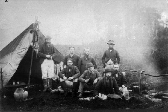
’Stephenson Percy Smith and his survey party’, black and white
photograph, ½-061056, F, Alexander Turnbull Library, National Library of
New Zealand/Te Puna Matarauranga o Aotearoa
NEGOTIATING CULTURAL BOUNDARIES
Despite the aggressive pace of the British
colonisation of New Zealand post-1840, most of the early colonial land
surveyors were keenly aware that they were not ‘first-time’ explorers,
but were traversing landscapes that were already known, named and mapped
by indigenous Maori. Certainly, from the 1840s through to the 1860s the
land surveyors’ efforts to name, tame and claim the land were much less
an exercise in possessing it outright and more about transitioning the
meaning of land (its value, attributes and qualities) from one cultural
framework to another. From the 1860s, and especially with the operation
of the Native Land Court from 1865 onwards, the work of land surveyors
took on a more formidable role as Maori land was transferred from
collective customary tenure to individual Crown-derived titles and, in
many cases, was permanently alienated. This meant that land surveyors
were in frequent contact and negotiation with resident Maori
communities; indeed, for many communities, the land surveyor was the
‘face’ of the new colonial order.
Fortunately, many of the early land surveyors
recorded their contact with Maori in great detail, often acknowledging
their dependence on their Maori assistants, cooks and chainmen. The
early land surveyors also noted that Maori survey hands—accurately
referred to by surveyors as 'the compass'—were especially valued for
their navigational skills. Indeed, Maori often proved more able than
European assistants. John Rochfort, who surveyed in the Nelson and
Canterbury provinces in the South Island during the 1850s, chose to
employ only Maori survey hands. While surveying the boundaries of the
Canterbury and Otago provinces in 1858, Edward Jollie wrote how he 'took
an old Maori with me named "Governor Grey", who had lived for some time
in the Wanaka District' and the ways in which he relied upon this
particular guide. Women, too, worked in this capacity. In January 1844,
when Jollie travelled from the Manawatu River [in the North Island] back
to Wellington, he and his party 'secured a canoe to take us the first 12
miles of our journey, the crew consisting of two Maori girls'.(7)
Maori responded to the increased demand for their
services from the land surveyors by adapting and expanding their
existing economic networks. Arthur Dobson, for instance, wrote that on
the West Coast of the South Island, 'as time went on able-bodied young
men that I had working for me sent word to the various pas (Maori
village settlements) down the coast that I was coming, and that I would
pay for help for canoeing on the rivers'.(8) When Dobson arrived to
commence his survey, members of the local tribe Ngai Tahu, were ready
and waiting for business.
Maori employed as guides for the colonial land
surveyors therefore played a contradictory role in the surveying and
exploration of New Zealand. These contradictions were particularly acute
when European explorer-surveyors paid indigenous Maori guides, who were
already familiar with the area, to assist them in their 'discovery'. In
the Australian context, Henry Reynolds has considered how European
explorers used Aboriginal guidance to ‘open up’ much of the Australian
continent to European settlement. Paul Carter has also observed how in
Australia the European explorer was more often led than leader. Apart
from complicating what we mean by the term ‘exploration’ in the early
colonial period, this engagement clearly posits Maori and other
indigenous actors as active, rather than passive players in the larger
colonial project.(9)
The negotiation of this sort of boundary making
eventually cut both ways, however, and Maori opposition to surveying was
not uncommon as lines were drawn, often arbitrarily, through
cultivations and across tribal boundaries. Indeed, from the 1860s
onwards, for many Maori communities the presence of the land surveyor
became a metaphor for loss and a portent of impending land alienation.
According to land surveyors who worked in Taranaki [in the southern
North Island], Maori frequently (and publicly) demonstrated their
opposition to the conduct of land surveys. While laying out the
settlement of New Plymouth, a New Zealand Company settlement in the
lower North Island Taranaki region during the early months of 1841,
Frederick Carrington was confronted by 'natives from the interior who
said we that we should not cut any more. They flourished their
tomahawks, and danced and yelled, and I thought we should all be
massacred.'(10) In Taranaki, this reaction was not surprising, given
that many of the purchases were highly contested, both at the time, and
later, in the form of submissions to successive government commissions
of inquiry. Tensions between the Ngati Toa tribe and the New Zealand
Company land surveyors working at Wairau, near Nelson in the north of
the South Island, reached a climax in June 1843, when 22 settlers and
six Maori were killed. The incident followed an attempt by officials of
the New Zealand Company in Nelson to seize by force land from the great
rangatira (chief) Te Rauparaha, who denied having sold the land.
For Maori, the surveyor's theodolite—commonly
referred to as the 'taipo' or 'tipo'—was also a symbol of uncertainty
and possible conflict. From the 1840s, the erection of survey poles,
like the traditional pou whenua marker-poles of Maori society, signified
an explicit and aggressive act of possession. Maori leaders therefore
often regarded the intrusion of the surveyors and their boundary markers
as overt challenges to their mana. While surveying Ngai Tahu land
reserves in the South Island in September 1848, the surveyor Walter
Mantell noted how '[t]wo or three old men not understanding the erection
of a pole at their huts at Waitueri threw it away with the others which
the man carried. I went down [and] lectured them [and] explained the use
of the pole and remained there.'(11) There is much evidence to suggest
that Maori well understood the erection of the survey poles, and their
removal was a deliberate act of protest at Mantell's marking out of the
reserves. The surveyor Edwin Brookes cited the suspicion Taranaki Maori
held towards the theodolite in the 1870s: 'The invariable expression
that would come over them after a long drawn breath was "taipo", meaning
evil spirit: by my interpretation was—a mystery, or something
mysterious. In order to show them a friendly spirit, I would allow many
of these natives to look through the telescope, when they would withdraw
from it much perplexed.'(12) While impressed by the technology, Maori no
doubt appreciated the powerful role of the theodolite in the survey and
alienation of their lands.
The initial phase of breaking in the land,
establishing European settlements and striving for political dominance
led to increasing tension between Maori and surveyors. According to the
records created by the land surveyors themselves, resistance from Maori
towards the progress of surveys continued well into the latter half of
the nineteenth century. Under the instructions of Wi Kingi Te Rangitake,
for instance, women pulled up the survey pegs at Waitara [near New
Plymouth] in February 1860 to demonstrate their opposition to the survey
of what is now considered to be a highly disputed 'purchase'. In other
parts of Taranaki there were frequent incidents of antagonism between
Maori and surveyors. While laying out military settlements in north
Taranaki during 1865-66, Stephenson Percy Smith worked under the
protection of armed military covering parties. Given that Smith's
surveying work was part of implementing the punitive policy of land
confiscation (the raupatu), it seems hardly surprising that Maori
directed their frustration at surveyors, the most visible agents of this
pernicious policy.(13)
These examples of conflict serve both to illustrate
the precarious position occupied by the early land surveyors working in
the field and highlight how an indigenous Maori system of naming and
mapping pre-dated and indeed co-existed with the new order imposed by
the colonial land surveyors. For Maori, boundaries on the land formed
the basis of an indigenous system of mapping. As the basis of tribal
economy and community life, land was identified through a complex system
of rights and privileges that relied on physical as well as cultural
boundary markers. While whakapapa (genealogical) connections, waiata
(song), and 'mental maps' were used in navigating the land, boundaries
were indicated by geographical features such as hills, rock formations
and rivers. Stones, wooden posts and holes dug into the ground also
functioned as markers between tribal areas, and individual cultivation
plots were often the most enduring divisional marks. Maori also diverted
streams and constructed estuarine canals to assist with fishing and to
act as boundary markers. Prior to organised British settlement in the
mid nineteenth century, there was little need to precisely delineate
physical boundaries. From that point forward, however, boundaries on the
land became symbols of identity, ‘ownership’ and esteem; established and
legitimized in public and official discourse and given popular currency
by government legislation. Western capitalist ideas of land tenure and
individual property ownership then quickly dominated. The land wars, and
their issue—the Native Land Courts and the raupatu—also played a role in
this fundamental shift in thinking. While indigenous Maori perceptions
of land use and ownership continued, European (and especially British)
ideals about land usage and administration soon became the norm rather
than the exception.
CONCLUSION
While much of the map of modern New Zealand is
testimony to the work of the early colonial land surveyors, they have
been largely overlooked as a founding group of colonists in this
country’s history. Notwithstanding a few recent publications that have
attempted to remedy this oversight, it is something of a paradox that
while the dominant story of New Zealand has written them out of history,
the land surveyors themselves had been actively engaged in writing
themselves in. Their legacy lives on in placenames that survive as
historical artefacts from another era. Indeed, in almost every corner of
contemporary New Zealand, the land surveyors’ names and descriptors can
be found in geographical features, suburbs, districts and even streets.
Finally, the diaries and field books of the colonial land surveyors
offer valuable evidence to the interested reader. As well as containing
technical details regarding the conduct of early land surveying, these
records reveal rich and detailed botanical and ethnological information
as well as personal reflections on the processes of land transformation
and settlement.(14)
Land surveying was fundamental to the British
colonizing vision and the acquisition of new territories, such as New
Zealand, for settlement. The work of the colonial land surveyors
reflects much that is central to the history of New Zealand,
particularly the transformation and domestication of the natural
environment. The land surveyors were crucial in effecting change, as
they occupied a central role in implementing the principles of
colonization on the ground: they operated, quite literally, at the
‘cutting edge’ of colonization. Their work deserves, therefore, to be
remembered, though it also needs to be understood in context. While it
would be tempting to oversimplify the contribution of the land surveyors
to New Zealand’s past, and (depending on your point of view) to either
valorize or demonize their work as colonial entrepreneurs, it is worth
remembering that the land surveyors were agents of their time who were
capable of questioning the longer-term outcomes as well as the immediate
impact of their work. We need to remember them as complex historical
actors whose work has shaped the contours of our historical trajectory
and fashioned our modern society in ways more powerful than we fully
realize.
ENDNOTES
-
Land alienation, in addition to a range of other
issues, is the subject of the vast majority of claims by modern
Maori to the Waitangi Tribunal, a commission of inquiry established
in 1975 to inquire into the allegations by Maori tribes that the
Crown has consistently failed to honor its responsibilities under
the 1840 Treaty of Waitangi. See further, Claudia Orange, The
Treaty of Waitangi, Allen and Unwin, Wellington, 1987; Alan
Ward, An Unsettled History: Treaty Claims in New Zealand Today,
Bridget Williams Books, Wellington, 1998; Giselle Byrnes, The
Waitangi Tribunal and New Zealand History, Oxford University
Press, Melbourne, 2004.
-
Surveying in North America embraced both types of
survey, while in the Australian colonies, planned rectilinear (or
equal square) land division was the most common practice. Chain
surveying was also a common practice, where the Gunter’s chain,
66-foot long and divided into equal links, was used for calculating
distance.
-
John Rochfort, The Adventures of a Surveyor in
New Zealand and the Australian Gold Diggings, London, 1853.
-
Edward Jerningham Wakefield, Adventure in New
Zealand, first edition John Murray (ed.), London, 1845, revised
edition Joan Stevens (ed.), Auckland, 1975, pp. 233-34.
-
John Turnbull Thomson, ‘Extracts from a journal
kept during the reconnaissance survey of the southern districts of
the province of Otago’, in Nancy Taylor (ed.), Early Travellers
in New Zealand, London, 1959, p. 347. See also John Turnbull
Thomson, MS-Papers-0176, Alexander Turnbull Library, Wellington, and
John Turnbull Thomson, Rambles with a Philosopher, Dunedin,
1867.
-
Charles Heaphy, Narrative of a Residence in
Various Parts of New Zealand, London, 1842, p. 23.
-
Rochfort, The Adventures of a Surveyor;
Jollie wrote 'this old Maori was named after Sir George Grey the
Governor—twice—of New Zealand, by I believe, Mr Walter Mantel
[sic].' Edward Jollie, Reminiscences 1825-94, MS-Papers-4207,
Alexander Turnbull Library, Wellington, p. 27. Similarly, the wives
of Kehu and Pikewate joined them in guiding Thomas Brunner down the
West Coast of the South Island on his 'Great Journey' of discovery
in 1846-48.
-
Cited in Arthur Dudley Dobson, Reminiscences
of Arthur Dudley Dobson, Engineer, 1840-1930, Christchurch,
1930.
-
Henry Reynolds, 'The land, the explorers and the
Aborigines', Historical Studies, vol. 19, no. 5 (1980), pp.
213-26; Paul Carter, The Road to Botany Bay: an essay in spatial
history, London, 1987, p. 340.
-
F. A. Carrington, cited in William H. J. Seffern,
Chronicles of the Garden of New Zealand Known as Taranaki,
New Plymouth, 1896, p. 47.
-
Walter Mantell, 'Journal Kaiapoi to Otago,
1848-49', MS-Papers-1543, Alexander Turnbull Library, Wellington.
-
Edwin Brookes, Frontier Life: Taranaki, New
Zealand, Auckland, 1892, pp. 38-39.
-
The confiscation of Maori land, or raupatu, was
ushered in under the rather euphemistically titled ‘The New Zealand
Settlements Act 1863’.
-
As Nola Easdale has shown in New Zealand and
Stephen Martin for Australia, surveyors’ diaries and field books are
particularly rich historical sources. See further Nola Easdale,
Kairuri, the measurer of land: the life of the nineteenth century
surveyor pictured in his art and his writings, Highgate/Price
Milburn, Petone, 1988; Stephen Martin, A New Land: European
perceptions of Australia, 1788-1850, Allen & Unwin, St Leonards,
New South Wales, 1993.
BIOGRAPHY
Professor Giselle Byrnes is Pro
Vice-Chancellor of the Faculty of Law, Education, Business and Arts at
Charles Darwin University. Professor Byrnes moved to the Northern
Territory from New Zealand in mid 2011 with her family to take up this
role. She was formerly Professor of History and Pro Vice-Chancellor
(Postgraduate) at the University of Waikato, Hamilton, New Zealand
(2007-2011).
Giselle Byrnes completed a PhD in History at the
University of Auckland in the mid-1990s and then worked as an historian
for the Waitangi Tribunal. She returned to academia in 1997 and taught
in the Department of History at Victoria University of Wellington for a
ten-year period (1997-2007). Here she established the Public History
programme and developed a suite of courses in social and cultural
history, with a particular emphasis on exploring history in colonial and
postcolonial contexts.
Professor Byrnes' publications include Boundary
Markers: Land Surveying and the Colonisation of New Zealand (2001), The
Waitangi Tribunal and New Zealand History (2004) and The New Oxford
History of New Zealand (2009), for which she was Editor. She has also
published numerous articles on various aspects of colonial, settler and
Indigenous histories, in addition to public history. While the focus of
her work has been grounded in New Zealand historical experiences, she
has expertise in comparative colonial and transnational historical
methodologies.
In 2006 Giselle Byrnes was Fulbright Visiting
Professor in New Zealand Studies at Georgetown University, Washington
DC, and she has served a term as National President of the New Zealand
Historical Association.
CONTACTS
Professor Giselle Byrnes
Faculty of Law, Education, Business and Arts
Charles Darwin University
E-mail:
Giselle.Byrnes@cdu.edu.au
FIG-IIHSM CONFERENCE AT NORFOLK ISLAND
Visit Norfolk Island and experience the historic site together with FIG
International Institution for the History of Surveying and Measurement,
who invites you to Charting and Mapping the Pacific Paradise of the
Pitcairners Conference The conferences will be held at Norfolk
Island, New Zealand, 6-10 July 2014.
 |


