Article of the Month - February 2020
|
Possibilities of implementing crowdsourcing
initiatives in rural development programmes in Poland
Wioleta Krupowicz, Adrianna Czarnecka, Poland,
Magdalena Grus, Netherlands
 |
 |
 |
| Wioleta Krupowicz |
Adrianna Czarnecka |
Magdalena Grus |
This article in .pdf-format
(16 pages)
This paper was presented at the FIG Working Week 2019
in Hanoi, Vietnam. The article presents the possibilities of
implementation of the idea of crowdsourcing in rural development
programmes in Poland
SUMMARY
Rural areas in Poland are inhabited by 39.8% of the country’s
population (GUS, 2018a). They face various challenges in the scope of
development of efficient and competitive agriculture and forest economy,
strengthening of area structures as an independent living and economic
space, and preservation of cultural landscape and natural environment.
Measures aimed at the improvement of rural development instruments have
been undertaken in Poland for many years. The Rural Development
Programme for the years 2014-2020, specifying the framework of
development of rural areas in Poland, draws attention to the need of
activation of residents of rural areas, and use of endogenic potentials
for the purposes of local development. The entire process of spatial
planning in rural areas in Poland requires undertaking measures
promoting creative attitudes among residents of rural areas and enabling
their involvement in joint undertakings.
One of the tasks of ongoing rural development projects is to take
social conditions into consideration. The research seeks potential
activities to be undertaken by local self-governments interested in the
development of local identity and sense of belonging. The development
and common use of the Internet and new digital tools come with a wide
range of new possibilities, challenges, and perspectives in the scope of
rural development. One of such tools is crowdsourcing. The survey
applies this relatively new approach to knowledge acquisition,
information diffusion, and exchange of thoughts and views among
authorities, experts, and the crowd. It entails a combination of
top-down, traditional, hierarchical process, and a bottom-up, open
process engaging an online community. The analysis of trends observed in
European policies reveals that the application of the idea of
crowdsourcing for strengthening social participation is a very desirable
and important issue.
The article presents the possibilities of implementation of the idea
of crowdsourcing in rural development programmes in Poland, particularly
in planning works related to the implementation of land consolidation. A
dedicated application was created in the GIS environment especially for
this purpose.
1. INTRODUCTION
Rural areas in Poland face many challenges in the scope of efficient
and competitive agriculture and forest economy, strengthening area
structures as an independent living and economic space, and preservation
of the values of the cultural landscape and natural environment. Poland
stands out in Europe in terms of its environmental and landscape
diversity. This results from the natural conditions (diverse land relief
and variability of soil and climate conditions), uneven
industrialisation and urbanisation of the country, high contribution of
permanent grasslands, and preservation of extensive agriculture over a
considerable area, particularly in regions with mosaic spatial structure
(in the eastern and south-eastern part of the country) (Kaługa 2009).
Arable land constitutes 60.2% of the territory of the country (GUS,
2018b). Half of it constitutes unique habitats disappearing in the
European landscape, with havens of rare and endangered species of flora
and fauna (Machnik and Kurczewski, 2014). High environmental and
landscape values of agricultural areas are confirmed by covering their
considerable part by the Natura 2000 network (Gwiazdowicz, 2010).
Reconciling the economic development of rural areas with environmental
and landscape protection is a difficult task. Activities with this goal
in mind have been undertaken in Poland for many years in the framework
of the Common Agricultural Policy of the European Union.
Rural development in Poland is currently stimulated by the Rural
Development Programme for the years 2014-2020. It draws attention to the
need of activation of residents of rural areas, and use of endogenic
potentials for the purposes of local development. The entire process of
spatial planning in rural areas in Poland requires activities promoting
creative attitudes among residents of rural areas, and enabling their
involvement in joint undertakings. One of measures related to the
transformation of the spatial structure of rural areas in Poland,
implemented in the scope of the programme, is land consolidation.
Consolidation works performed so far did not make the most of the
knowledge resources of the local community regarding their area of
residence (in the scope of resources of local material and intangible
cultural heritage, local environmental conditions affecting agriculture,
functionality and quality of access roads to arable and forest land,
problem areas, etc.). This translated into: a unilateral character of
the solutions of the consolidation plan, and the exclusive consideration
of the improvement of the area structure of agricultural farms and
transportation system, lack of implementation of the currently promoted
idea of sustainable development of areas, non-optimal use of funds for
the purposes, and a small number of implemented consolidation
procedures.
The development and common use of the Internet and new digital tools
comes with a broad range of new possibilities, challenges, and
perspectives in the scope of development of rural areas. One of such
tools is crowdsourcing – a tool allowing for effectively reaching the
interested social groups, use of their knowledge on the area, acquiring
their opinions and ideas, and then their involvement in the
implementation of the planning works. It permits the inclusion of the
community in the decision-making process regarding the type of aspects
of space that should be considered in the implementation of works
related to the transformation of the space of rural areas, as well as
acquiring detailed information on the study area, not available in the
existing spatial data bases. It may also result in the development of
innovative solutions by reducing the cost and time usually required in
the traditional problem-solving process (Brabham, 2008).
Public participation is a key priority in public planning and
crowdsourcing. It is regarded a good way to engage citizens and
facilitate an open dialogue between them and planners (Bugs et al.,
2010). The analysis of trends observed in the European policy (projects
CAPS – Collective Awareness Platforms for Sustainability and Social
Innovation) shows that the application of the idea of crowdsourcing for
the purpose of strengthening of social participation is a very desirable
and important issue. Numerous examples also include among others
crowdsourcing platforms engaging residents in common search for
solutions to local problems, as well as in transforming, improving, and
governing the city, e.g. WeDundee.com in Scotland, FixMyStreet.com in
Great Britain, or OtwartaWarszawa.pl in Poland. Holland also has
considerable experience in the scope (among others Bol et al., 2016;
Grus and Sjoukema, 2017). It has been applying the tool in works related
to updating topographic maps with the support of elementary school
pupils for several years. OpenStreetMap (OSM) is the most famous example
of crowdsourcing available today (Haklay and Weber, 2008).
Land consolidation is one of the processes shaping the spatial
structure of rural areas. Therefore, the implementation of
consolidations (but also preparation of strategic documents for local
development affecting the functional-spatial structure of rural areas)
requires undertaking measures promoting creative attitudes among
residents of rural areas, and enabling their involvement in joint
undertakings. The article presents the concept of implementation of the
idea of crowdsourcing in processes transforming the spatial structure of
rural areas based on a dedicated application.
2. CHARACTERISTICS OF THE LAND CONSOLIDATION
PROCESS IN POLAND
One of the basic measures contributing to the development of
agriculture and rural areas in Poland, as well as in the countries of
the European Union (Vitikainen, 2004), is the land consolidation
process. Consolidation works in Poland currently gradually cease to be
treated as measures limited only to new planning of boundaries of
registered plots optimal only from the point of view of owners of
agricultural farms. From the moment of Poland’s accession to the
European Union (in 2004), land consolidation increasingly frequently
constitutes an element of a group of measures aimed at complex
development of an area subject to consolidation, with consideration of
complex renewal of villages, improvement of the transport system,
protection of the natural environment, protection of landscape values
and cultural heritage, and improvement of water relations (Bielska and
Leń (eds.), 2015; Krupowicz et al., 2017; Kupidura et al., 2014;
Sobolewska-Mikulska (ed.), 2015; Sobolewska-Mikulska and Wójcik, 2018;
Stańczuk-Gałwiaczek et al., 2018; Wilkowski and Pułecka, 2002).
Poland is one of the largest beneficiaries of EU projects oriented at
rural development, where the land consolidation process is of particular
importance (Janus and Markuszewska, 2017). Poland currently experiences
high demand for implementation of such works. The needs in the scope
cover more than 7 million ha, constituting approximately 69% of the area
of arable land of family farms in the country (Jędrejek et al., 2014).
Depending on the region, they are respectively larger or smaller. The
greatest needs concern the southern, south-eastern, and central part of
the country, due to a small surface area of plots and their high
dispersal (Jadczyszyn and Woch, 2017). In the programming-financial
perspective 2014-2020, approximately 285 million EUR is allocated for
the implementation of land consolidation procedures. This will permit
the consolidation of land with a total surface area of approximately 106
thousand ha (Programme, 2018).
2.1 Legal regulations and technical procedures
As directly stipulated by the Act of 26 March 1982 on land
consolidation and exchange (Journal of Laws of 2018, item 908)
regulating the land consolidation procedure in Poland, the objective of
this type of measures is the provision of more favourable management
conditions in agriculture and forestry through the improvement of the
area structure of agricultural farms, forests, and forest land, rational
management of the plot layout, adjustment of real estate boundaries to
the system of melioration facilities, roads, and land relief. The scope
of the measure covers a number of surveying, legal, and administrative
activities necessary for initiating the consolidation procedure,
conducting administrative proceedings, and disclosure of the decision on
the approval of the consolidation plan in the land and buildings
register and in land and mortgage registers. It particularly covers the
preparation of the consolidation plan (surveying-legal documentation),
as well as implementation of post-consolidation management –
particularly considering the construction and adjustment of agricultural
transport roads, correction of the course and improvement of technical
parameters of melioration ditches, land reclamation, and implementation
of other measures resulting from the consolidation plan, permitting
taking possession of newly designated plots and land management in a
given area. Consolidation proceedings are performed by the starost as a
task in the scope of governmental administration from the resources of
the State Budget, with a prevalent contribution of financing from the
resources of the European Agricultural Fund for Rural Development. The
highest authority in the scope is the voivode. Consolidation works are
coordinated and performed by the voivodeship self-government with the
support of voivodeship offices of surveying and arable land.
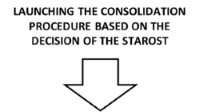
Two types of consolidation are designated: initiated on request and
ex officio. Pursuant to the act on land consolidation, initiation of the
consolidation procedure can occur on request of the majority (more than
50%) of owners of agricultural farms (with an area of more than 1 ha)
located in the designated consolidation area, or on request of owners of
land with a total area exceeding half the surface area of the designated
consolidation area (irrespective of the total area of land in
possession). In order to apply for financing of consolidation works, the
starost applies for financial resources in a competition announced by a
respective department of the Marshal Office. The criteria of admission
of applications are specified in the Regulation of the Minister of
Agriculture and Rural Development of 10 December 2015 on detailed
conditions and course of granting and provision of financial support for
land consolidation procedures, in the scope of submeasure “Support for
investments related to development, modernisation, and adjustment of
agriculture and forestry” covered by the Rural Development Programme for
the years 2014-2020 (item 2180). Preference is given to undertakings
that have a positive effect on the landscape and environment, and
implement allocation of land for public purposes and for tasks
increasing retention.
Consolidations initiated ex officio, particularly (after obtaining
the opinion of the village administration and social-vocational farmer
organisations operating in a given village) so-called infrastructural
consolidations, are implemented in an area where the plot layout was or
will be considerably worsened as a result of the course of the existing
or constructed public roads (particularly motorways), railways,
on-ground pipelines, and water reservoirs or melioration facilities. The
objective of such consolidation is to eliminate or minimise the
unfavourable effect of investments on rural space. The costs of
consolidation works and post-consolidation management are covered by the
investor, if they apply for the consolidation. Next to the
aforementioned types of land consolidations, the following are also
implemented in Poland (Sobolewska-Mikulska (ed.), 2015):
- Land consolidations related to the implementation of anti-flood
investments, aimed at obtaining real estate for the purposes of
construction of anti-flood structures,
- “secondary” land consolidations resulting from secondary
fragmentation of the area structure of agricultural farms in already
previously consolidated areas, or liquidation of common land,
consolidation of forests and forest land, alteration and
modernisation of agricultural transport roads, counteracting
erosion.
The course of the land consolidation process in Poland is presented
in Figure 1.
Figure 1. Land consolidation procedure in Poland (red colour
designates elements of the procedure involving active participation of
the local community)
DETERMINATION OF NEEDS AND QUALIFICATION
OF THE OBJECT FOR CONSOLIDATION
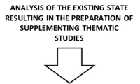 |
The analyses are performed based on the following data:
- Land and mortgage registers,
Land and buildings register,
- soil-agricultural maps,
- spatial management plan of the commune, study of the
conditions and directions of - spatial management of the
commune,
- agricultural land management programmes,
results of field inventory,
- social consultations
involving the identification of the needs of the local
community,
- consultations with institutions from the industry
- Digital Terrain Model (DTM).
The analyses result in the preparation of the following thematic
studies:
- study of land relief,
- study of soil erosion,
- study of soil classification of arable land,
- study of land governance,
- study of plot surface area,
- study of spatial distribution of plots of a group of
farms with the greatest surface area,
- study of spatial distribution of plots of a group of
farms with the highest number of plots,
- study of forest and tree stand cover with proposed
agricultural-forest boundary,
- study of existing and planned roads,
- study of plots with no access road,
- study of water relations,
- study of land use by field inventory, inventory and
photographic documentation.
|
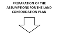 |
The graphic part of the concept presents:
- boundaries of the consolidation area,
- proposals
concerning changes in the boundaries of communes or villages,
- land excluded from consolidation,
- proposals of
changes in the arable land structure, and of designation of land
allocated for forestation, development of wind protection belts,
anti-erosion measures, etc.
- requirements in the scope of
maintenance and protection of field tree stands, tree stands and
bushes constituting biological enclosure of water streams,
gullies, ravines, high balks – counteracting erosion phenomena,
- correction of the course of the existing melioration
canals and ditches requiring renovation, and planning of
melioration ditches in areas requiring meliorations,
- proposals for the range of reclamation,
- needs in the
scope of changes in the transportation system with consideration
of footpaths and road crossings, - proposals for the
location of land of large-area farms, commune property, common
land, etc.,
- proposals for road management,
- improvement of water conditions and water management,
- direction of planning plots,
- changes in the land use structure,
- designed agricultural-forest boundary,
- tree stands and bushes,
- protected areas, location of land for public purpose
investments.
|
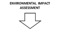 |
- Preparation of the environmental study for land
consolidations with an area of arable land exceeding 10 ha
in areas covered by forms of environmental protection and
100 ha for the remaining areas.
- Decision (issued by the starost) on the obligation of
preparation of the EIA report or revoking the obligation.
Issuing the decision on environmental conditions (issuing
authority – starost).
|
 |
- Election of the Council of Consolidation Participants
(up to 12 persons among the participants – as a consulting
authority).
- Appointment by the starost of the Commission fulfilling
consulting functions in the preparation of the comparative
land appraisal and issuing opinions on reservations to the
consolidation plan.
|
 |
- Passing the rules of land appraisal by consolidation
participants.
- Preparation of the map of land appraisal and register of
comparative land appraisal before consolidation, and
disclosing them to the public.
- Detailed and thorough analysis of particular appraisal
contours in the field.
|
 |
- Measurement of invariable elements of the plan –
external boundary (protocol designation on land with plot
owners), built-up plots (protocol designation on land with
plot owners), roads (protocol designation on land with road
administrator), waters (protocol designation on land with
administrator), agricultural-forest boundary.
- Collection of requests from consolidation participants
in writing in terms determined in a notification letter.
- Divisions of common land – in the case of requests for
such works.
- Planning plots of the new state based on collected
requests and performed measurements of invariable elements.
- Preparation of the register of comparative appraisal of
land designated as a result of consolidation.
- Preparation of the list of planned plots and cash
equivalents.
|
 |
- Elevation, stabilisation, and presentation in the field
of the planned new plots.
- Presentation of the plan and collection of
complaints
regarding the plan.
- Examination of the justification of the complaints by
the starost (after prior issuing of an opinion by the
Commission) and introduction of potential amendments to the
plan.
|
 |
- Decision approving the land consolidation plan together
with the conditions of gaining possession of land designated
as a result of the consolidation, and ways of settlements
constituting an integral part of the decision (terms and
rules of gaining possession of new plots, scope of
reclamation works, list of new planned roads, and existing
roads for modernisation, etc.).
- Update of the land and buildings register and
commencement of works related to post-consolidation
management.
- Disclosure of the new legal state in land and mortgage
registers.
|
 |
Post-consolidation management includes works involving:
- construction of adjustment of access roads to arable and
forest land, and access roads to homesteads of particular
consolidation participants,
- correction of the course
and improvement of the technical parameters of melioration
facilities,
- liquidation of redundant balks and roads, and
performance of reclamation measures permitting mechanical
cultivation of land (among others removal of bushes,
planation of ditches, removal of balks, ploughing).
|
2.2 Participation of the local community
The scope and character of participation of the local community in
consolidation proceedings is stipulated in legal provisions (Act, 1982).
The land consolidation process is implemented with the participation of
the Council of Consolidation Participants consisting of 3-12 persons as
a social consulting authority appointed by the consolidation
participants. It fulfils consulting functions towards the surveyor,
planner, and starost – it issues opinions on reservations to the plan,
proposes the course of new roads. Consolidation participants have an
important role of submitting individual requests concerning the location
of their plots, and pass the rules of estimation providing the basis for
the accurate determination of the value of land. Customarily in the
Polish consolidation procedure, residents of the consolidation area do
not actively participate in the planning works. It is a manifestation of
social participation with informative and consultation character.
Residents participate in the following stages of the process (see Figure
1):
- analysis of the existing state resulting in the preparation of a
group of thematic studies,
- launching the consolidation procedure on request of the majority
of owners of agricultural farms located in the area of the planned
consolidation, or on request of owners of land with a total area
exceeding half of the surface area of the planned consolidation
area,
- land estimation,
- preparation of the detailed plan and register of comparative
land estimation after consolidation,
- presentation of the plan and collection of complaints concerning
the plan.
In such a situation, residents have no actual influence on the
planned investment measures (directly or indirectly) concerning them.
Only actual participation of the local community in the design works
allows for minimising the number of socio-spatial conflicts, and for
obtaining social acceptance in the scope of decisions taken in the scope
of the land consolidation procedure (Hindsworth and Lang, 2009; Urbanik
et al., 2010).
A measure that would enable active and actual participation of the
local community in shaping their space of residence, as well as building
the sense of local identity and belonging to the place of residence, is
the concept of implementation of the idea of crowdsourcing at the stage
of planning of consolidation works, recommended in this article. As a
consequence, the community assumes shared responsibility for the
undertaken measures and decisions, making the entire process more
permanent and effective.
3. PROPOSAL OF APPLICATION OF THE IDEA OF
CROWDSOURCING FOR THE PURPOSE OF IMPROVED USE OF THE POTENTIAL OF THE
LOCAL COMMUNITY IN RURAL DEVELOPMENT PROJECTS
3.1 Study material and methods
In the approach proposed in this article, crowdsourcing for the
purposes of implementation of land consolidation in Poland can be
considered as a process evolving through the following steps (Figure 2):
- online presentation of a problem,
- obtaining opinions, needs, information from stakeholders
(potential consolidation participants) regarding:
- local environmental conditions affecting land and crop
cultivation (for example scarps, balks, self-sown forest,
shading by trees),
- functionalities and quality of access roads to arable and
forest land (for example roads with damaged surface,
inaccessible during snowmelts and excessive precipitation, dirt
roads, unadjusted to modern means of transport, machines, and
agricultural tools, requiring paving, unused roads, informal
roads – occasional crossings through neighbouring land (see
Krupowicz et al., 2017)),
- agricultural problem areas resulting from the spatial
variability of the natural environment, particularly including
soil and water conditions, and reckless human activity (for
example mountain areas, land damaged by erosion, land threatened
with steppisation, wetlands or stony land, wastelands,
devastated and degraded land (see Sobolewska-Mikulska and
Wójcik, 2018; Wójcik-Leń et al., 2018)),
- resources of local material and intangible cultural heritage
not constituting an element of the existing spatial data bases,
such as: important places related to local traditions, customs
(for example wetlands where flax was soaked, holly springs,
magic places, places related to local legends or beliefs),
places important for residents, memorial places (of burial,
forgotten graves), locations of already non-existent buildings
such as mills or windmills, etc. They are generally places which
could be preserved and marked in the physical space of a village
in the scope of the post-consolidation management (see Kupidura,
2013; Kupidura, 2017)),
- others (it is an open group, depending on the local
conditions and needs).
- generation of alternative solutions by the stakeholders
(potential consolidation participants),
- evaluation of the solutions proposed by the stakeholders
(potential consolidation participants) and surveyor-planner,
- selection of the best solution provided by the surveyor-planner,
and
- introduction of the selected solution in the assumption of the
land consolidation plan.
Figure 2. Concept of crowdsourcing for the land consolidation
procedure in Poland
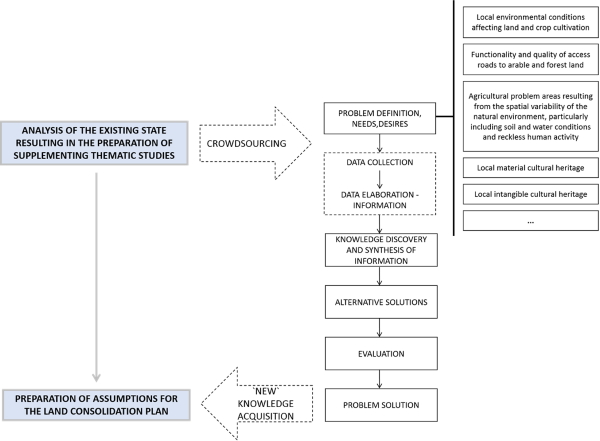
Source: own elaboration based on Papadopoulou and Giaoutzi (2014).
3.2 Application prototype
The objective of the application is on the one hand the disclosure of
the existing reference data concerning the selected area, and on the
other hand collecting data from the local community (crowdsourcing data
layer). The tool for the provision and collecting data will be a web
application available for stakeholders in the online environment. The
web application will be developed by means of ArcGis Online software by
Esri. It will be composed of reference data, e.g. base map, descriptive
layer concerning terrain attributes, and crowdsourcing data layer
permitting adding point data (with a description and/or photograph) by
the local community. The reference data and crowdsourcing data layers
are disclosed as feature service in the ArcGIS Online cloud. The feature
service is available for users through web applications, allowing for
adding and supplementing new data on a current basis (see Figure 3).
Depending on the needs, some data can be hidden or disclosed only to a
specified group of people. The user will be able to gain access to the
online application through a link or a generated QR code. The online
application will be available for iOS, Android, and Windows, and
displayed on mobile phones, tablets, and desktops. Access with no
necessity of prior logging in is assumed. The only condition of use of
the online application is access to the Internet.
Figure 3. Web application architecture
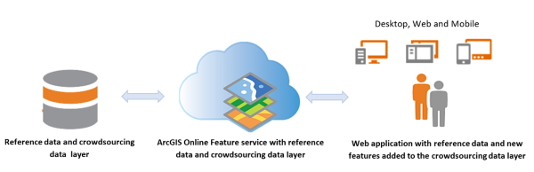
Source: own elaboration.
The presentation and testing of the application in the field will
involve three parts: introduction, practical test, and questionnaire. At
the introduction stage, the promoter (surveyor-planner) will briefly
explain the test’s objectives, the interface, and its functionalities,
and encourage users to use the web application. In the second part,
participants will implement a task. Users can interact for as long as
they need. Participants will be encouraged to go outside using the web
application. Last, they will answer a questionnaire with five direct
questions and three open questions (Table 1). The direct questions will
consider topics related to the ease-of-use, satisfaction and usefulness.
The open questions will serve mainly to analyse the usefulness of its
functionalities and tools for future improvements.
Table 1. Questionnaire
Do you agree with these statements? () yes () no
1. I found the web application easy to use and understand
2. I think that people in general would be able to use a web
application like this easily
3. I found the information interesting and important
4. I think this web application can strengthen public participation
in land consolidation process
6. I think all municipalities should have a web application like
this available for the community in the case of implementation of
documents affecting the functional-spatial structure of rural areas
Please answer:
6. What did you like most and what did you dislike?
7. What do you think is missing?
8. What do you think could be improved?
Source: own elaboration based on Bugs et al. (2010).
3.3 Discussion
The presented issues and data obtained from the local community will
allow for a better and more detailed examination of the consolidation
area by the surveyor-planner, and therefore more accurate consideration
of the useful, spatial, environmental, and landscape values in the
assumptions of the consolidation plan. We expect the proposed solution
to permit effective reaching of the interested social groups, use of
their knowledge on the area, acquiring their opinions and ideas, and
then their involvement in the implementation of the planning works. The
proposed solution offers a possibility of supplementing data used in
consolidation works by the perceptive level, related to experience,
preferences, associations, and memories of the local community
concerning their living space. This particularly concerns data related
to the cultural and landscape heritage of a given village (see Kupidura,
2013; Kupidura, 2017). The ideas and technical solution presented in the
article are currently undergoing tests on selected consolidation objects
in Poland.
& 4. CONCLUSIONS
Land consolidation is one of the processes shaping the spatial
structure of rural areas. Therefore, the implementation of
consolidations requires measures promoting creative attitudes among
residents of rural areas, and enabling their engagement in common
undertakings. It is possible through the application of the tool of
crowdsourcing. A dedicated application was developed in the GIS
environment especially for this purpose. The resulting obtained
information on the area and the problems and needs of the local
community will constitute input material for the surveyor-planner for
the preparation of assumptions of the land consolidation plan. Then,
they can be implemented in the land consolidation plan. The approach
presented in the article can additionally contribute to:
- increase in the acceptance of the local community for the
implementation of agricultural land management works and
transformations of the functional-spatial structure of rural areas,
unquestionably contributing to the improvement of land management
conditions – completion of the consolidation procedure provides the
basis for undertaking further common measures related to the
commencement of the broadly defined transformation of the village,
in the scope of possibilities of obtaining financial resources and
finding solutions to economic-investment and environmental-landscape
problems,
- increase in the interest of the local community in ways of
building the sense of local identity and belonging to the place of
residence,
- promotion of the quality of life in the village, or promotion of
the village as a place of life and professional development with
consideration of the economic, social, and environmental potential
of a given area,
- improvement of the spatial, technical, and aesthetic conditions
of building development in the village, and management of rural
areas through among others the use and promotion of the cultural
heritage of Polish rural areas,
- development of the digital society in rural areas through an
increase in the level of knowledge in the scope.
The methodological and technical solutions proposed in the article
will also be applicable in the preparation of other documents affecting
the functional-spatial structure of rural areas in Poland, such as:
development strategy of the commune, study of conditions and directions
of spatial management of rural communes, local spatial management plans.
REFERENCES
List of publications:
Bielska A., Leń P. (ed.), 2015. Scalenia gruntów determinantem
wielofunkcyjnego rozwoju obszarów wiejskich. Wyższa Szkoła
Inżynieryjno-Ekonomiczna w Rzeszowie, Rzeszów. (in Polish)
Bol D., Grus M., Laakso M., 2016. Crowdsourcing and VGI in National
Mapping Agency’s data collection. Proceedings, 6th International
Conference on Cartography and GIS, 13-17 June 2016, Albena, Bulgaria,
493-498.
Brabham, D.C. 2008. Crowdsourcing as a model for problem solving: An
introduction and cases. Convergence 14, 75–90.
Bugs G., Granell C., Fonts O., Huerta J., Painho M., 2010. An
assessment of public participation GIS and Web 2.0 technologies in urban
planning practice in Canela, Brazil. Cities 27(3), 172-181.
https://doi.org/10.1016/j.cities.2009.11.008
Grus M., Sjoukema J.W., 2017. Dutch Kadaster and crowdsourcing.
Conference materials, Crowdsourcing in National Mapping, 3-4 April 2017,
Leuven, Belgium.
GUS (Central Statistical Office), 2018a. Obszary wiejskie w Polsce w
2016 roku. Zakład Wydawnictw Statystycznych, Warszawa. (in Polish)
GUS (Central Statistical Office), 2018b. Rocznik Statystyczny
Rolnictwa 2017. Zakład Wydawnictw Statystycznych, Warszawa. (in Polish)
Gwiazdowicz M., 2010. Środowisko przyrodnicze na obszarach wiejskich
– zagrożenia i szanse. Studia BAS 4(24), 247–272. (in Polish)
Haklay M., Weber P., 2008. OpenStreetMap: User-generated street maps.
IEEE Pervasive Computing 7(4), 12-18.
https://doi.org/10.1109/MPRV.2008.80
Hindsworth M.F., Lang T.B., 2009. Community participation and
empowerment. Nova Science Publishers, New York.
Jadczyszyn J., Woch F., 2017. Problem rozłogu gruntów gospodarstw
rolnych o większej powierzchni. Polish Journal of Agronomy 31, 27–38.
(in Polish)
Janus J., Markuszewska I., 2017. Land consolidation – a great need to
improve effectiveness. A case study from Poland. Land Use Policy 65,
143-153.
https://doi.org/10.1016/j.landusepol.2017.03.028
Kaługa I., 2009. Korzyści dla rolnictwa wynikające z gospodarowania
na obszarach Natura 2000. Ministerstwo Środowiska, Warszawa. (in Polish)
Krupowicz W., Sobolewska-Mikulska K., 2017. Possible applications of
spatial analyses in designing the agricultural road network with
particular consideration of the environmental and landscape aspects, in:
The 10th International Conference Environmental Engineering, Čygas
Donatas (ed.), Vilnius Gediminas Technical University, 1-8.
https://doi.org/10.3846/enviro.2017.208
Krupowicz W., Sobolewska-Mikulska K., Burinskienė M., 2017. Modern
trends in road network development in rural areas. The Baltic Journal of
Road and Bridge Engineering 12(1), 48–56.
http://dx.doi.org/10.3846/bjrbe.2017.06
Kupidura A., Łuczewski M., Home R., Kupidura P., 2014. Public
perceptions of rural landscapes in land consolidation procedures in
Poland. Land Use Policy 39, 313–319.
https://doi.org/10.1016/j.landusepol.2014.02.005
Kupidura A., 2013. Dziedzictwo krajobrazowe w gospodarowaniu
przestrzenią. Prace naukowe, Geodezja, z. 53, Oficyna Wydawnicza
Politechniki Warszawskiej, Warszawa, 150 s. (in Polish)
Kupidura A., 2017. The role of landscape heritage in integrated
development of rural areas in the context of “landscape legal
regulation”. Infrastruktura i ekologia terenów wiejskich III/1/2017,
869-878.
http://yadda.icm.edu.pl/yadda/element/bwmeta1.element.baztech-31d0bc7b-bf7e-41d5-b92c-01cf9bae16d1/c/kupidura_the_role_3.1_2017.pdf
Machnik A., Kurczewski R., 2014. Dziedzictwo przyrodnicze w rozwoju
turystyki kulturowej na terenach wiejskich. Turystyka Kulturowa 7,
34-48. (in Polish)
Papadopoulou Ch.A., Giaoutzi M., 2014. Crowdsourcing as a tool for
knowledge acquisition in spatial planning. Future Internet 6, 109-125.
https://doi.org/10.3390/fi6010109
Sobolewska-Mikulska K. (ed.), 2015. Współczesne scalania gruntów w
kształtowaniu granic rolniczej przestrzeni produkcyjnej. Oficyna
Wydawnicza Politechniki Warszawskiej, Warszawa. (in Polish)
Sobolewska-Mikulska K., Wójcik-Leń J., 2018. Obszary problemowe
rolnictwa w Polsce. Wybrane aspekty realizacji scaleń gruntów. Oficyna
Wydawnicza Politechniki Warszawskiej, Warszawa. (in Polish)
Stańczuk-Gałwiaczek M., Sobolewska-Mikulska K., Ritzemab H., van
Loon-Steensmac J.M., 2018. Integration of water management and land
consolidation in rural areas to adapt to climate change: Experiences
from Poland and the Netherlands. Land Use Policy 77, 498-511.
https://doi.org/10.1016/j.landusepol.2018.06.005
Urbanik A., Boni Z., Koczanowicz-Chondzyńska J., 2010. Udział
obywateli w tworzeniu polityk publicznych. Wybór dobrych praktyk
zagranicznych. Fundacja Inicjatyw Społeczno-Ekonomicznych, Warszawa. (in
Polish).
Vitikainen A., 2004. An overview of land consolidation in Europe.
Nordic Journal of Surveying and Real Estate Research 1(1), 25-44.
https://journal.fi/njs/article/view/41504 Wilkowski W., Pułecka A.,
2002. Landscape aspects in land consolidation procedures in Poland.
Conference proceedings: XXII FIG Congress, Washington D.C., USA.
https://www.fig.net/resources/proceedings/fig_proceedings/fig_2002/Ts7-4/TS7_4_wilkowski_pulecka.pdf
Wójcik-Leń J., Sobolewska-Mikulska K., Sajnóg N., Leń P., 2018. The
idea of rational management of problematic agricultural areas in the
course of land consolidation. Land Use Policy 78, 36-45.
https://doi.org/10.1016/j.landusepol.2018.06.044
Others:
Decision No. 1 of the Minister of Agriculture and Food Economy of 24
March 1983 on land consolidation and exchange (GZ-g-630-1/83). (in
Polish)
Rural Development Programme for the years 2014-2020. Version as of
23.10.2018, European Agricultural Fund for Rural Development and
Ministry of Agriculture and Rural Development, Warsaw. (in Polish)
Act of 26 March 1982 on land consolidation and exchange (consolidated
text, Journal of Laws of 2018, item 908). (in Polish)
Guidelines for the preparation of assumptions for the land
consolidation plan with environmental impact assessment. Attachment No.
1 to Resolution No. 1191/14 of the Executive Board of the Małopolskie
Voivodeship of 30 October 2014, Department of Agriculture and Geodesy,
Marshal Office of the Małopolskie Voivodeship. (in Polish)
BIOGRAPHICAL NOTES
Wioleta Krupowicz, Ph.D. - Assistant professor at the Department of
Spatial Planning and Environmental Sciences, Faculty of Geodesy and
Cartography, Warsaw University of Technology (Poland). Valuer appraiser
with academic interest focusing on smart solutions for social,
environmental and economic challenges in rural areas, environmental and
landscape aspects in participatory planning in rural development
processes, land policy instruments for spatial development, real estate
appraisal.
Adrianna Czarnecka, Ph.D, D.Sc. - Assistant professor at the
Department of Spatial Planning and Environmental Sciences, Faculty of
Geodesy and Cartography, Warsaw University of Technology (Poland).
Landscape architect with academic interest focusing on public perception
of landscape, rural landscape changes, tangible and intangible landscape
heritage aspects in participatory planning in rural development
processes, landscape valuation, real estate appraisal.
Magdalena Grus - Product and Process Innovation Consultant at the
Cadastre. Studied Spatial Planning and Planning at the Warsaw University
of Life Science and Socio-Spatial Analyzes at Wageningen University and
Research in the Netherlands. From 2010 has been working with great
pleasure at the Cadastre, Land Registry and Mapping Agency (Kadaster) in
the Netherlands. In recent years active in the field of geographic
information systems, social geography and voluntary geographic
information. In the recent months working on IoT, DigitalTwin and
SmartCities. Searching for improvements and optimization of current
products and processes but also opportunities for the new products and
services. Actively looking for the social added value of technological
changes and the possibilities for active participation of the citizens.
CONTACTS
Wioleta Krupowicz, Ph.D.
Warsaw University of Technology
Faculty of Geodesy and Cartography
Department of Spatial Planning and Enviromental Sciences
Sq. Politechniki 1
Warsaw
POLAND
Adrianna Czarnecka, Ph.D. D. Sc.
Warsaw University of Technology
Faculty of Geodesy and Cartography
Department of Spatial Planning and
Enviromental Sciences
Sq. Politechniki 1
Warsaw
POLAND
Magdalena Grus, Msc.
The
Netherlands’ Cadastre, Land Registry and Mapping Agency
Hofstraat 110,
Apeldoorn
The Netherlands


