Article of the Month -
April 2018
|
A consideration for a conceptual
partnership framework in building spatial data infrastructures in
developing countries
 |
 |
| Lopang MAPHALE
|
Kealeboga Kaizer
MORERI |
This article is accepted as peer review
paper and will be presented at the congress 2018 in Istanbul, Turkey.
SUMMARY
This is a brief statement of the paper on Spatial Data
Infrastructures (SDI) and partnerships in the context of developing
countries. The concept of SDI started developing in the 1990s. Its real
explosion was felt after the 1993 presidential order 12906 by the then
United States of America President Clinton. It was held then that this
concept was going to spread and grow across the countries of the world
as it embraces geospatial information sharing across multiple
organizations. In terms of word, the concept did spread but in terms of
implementation coupled with growth it did not progress as anticipated
particularly in developing countries. They have struggled with the
implementation of this concept with African countries at the fore
front. To understand the challenges faced by developing countries, this
paper focuses on the aspect of partnerships. Partnerships are important
aspects which SDI foundations should be built upon. This paper explores
the SDI concept through its components and links it with the aspect of
partnerships. In so doing an SDI Partnership framework is advanced
which can be used by developing countries especially in Africa to pursue
their SDI developments. This framework is premised on the aspect of
institutional arrangements in respect to underlying behaviour, technical
and information policy issues. The framework is envisaged to guide SDI
adaptability analysis, modelling and design to meet a developing
country’s spatial data systems implementations. The usefulness and
significance of the framework was tested by interfacing it with existing
SDI assessments of African countries to prove that the proposed
partnership framework can be useful to their development and growth.
1. INTRODUCTION
A Spatial Data Infrastructure (SDI) is a conglomerate of geospatial
technologies and institutions fused with multi-sectoral professional
activity. If properly implemented and structured, it can play a leading
role in supporting major government, business and private
decision-making avenues This conglomeration of institutions together
with various professions need to be kickstarted and founded on good
working relations, which this paper refers to as partnerships. In the
last 30 years the need for partnerships in geospatial data collection,
processing and dissemination have been exposed by weaknesses such as
duplication of effort, wastage of resources and a lack of policies and
standards that enable functional partnerships to succeed. To address
these challenges, politicians like the USA President in 1994 through an
executive order 12906 and professionals like John McLaughlin in 1991
(GeoConnections, 2013) started looking at geospatial data as a resource
that can be developed into an infrastructure to benefit all stakeholders
and communities at large. This view has been emphasised by Crompvoets et
al. (2008), who stressed that spatial information should be treated as a
multi-stakeholder commodity meant to mutually benefit all those
involved.
Activities which promote partnerships in the development of SDIs are
its capabilities in spatial data sharing and exchange with the help of
Information and Communication Technologies (ICT). For data sharing
and exchange to happen effectively, sufficient collaborations and
coordination need to be established. Partnerships in the
development of SDIs can be controlled by an anchor structure such as an
SDI committee or coordinating organisation. Examples of such structures
are the USA Federal Geographic Data Committee (Williamson, Rajabifard, &
Enemark, 2003) and the European INSPIRE (Craglia & Annoni, 2006; Lipeg &
Modrijan, 2010).
Suggestions have been advanced early on regarding how developing
countries could initiate their SDI (Bishop et al, 2003) and most started
them towards the turn of the millennium. Meanwhile, SDI assessment
regimes were established in western countries like the SDI Readiness
Index (Fernandez, Lance, Buck, & Onsrud, 2005) and the INSPIRE State of
Play method (Vandenbroucke, Janssen & Van Orshoven, 2008). These methods
have recently been used to assess SDIs in developing countries
particularly in Africa. Makanga and Smit (2010) based their assessment
on the INSPIRE State of Play to assess 29 African countries, whilst
Mawange, Maluku and Siriba (2016) used the SDI Readiness Index over 13
African countries. In both studies it has been revealed that SDI
in Africa continues on an uphill struggle and its developments are
rather slow. Moreover, they stressed that new ways need to be
devised to aid SDI implementation in Africa. The foregoing has motivated
investigation of the phenomenon, leading to the suggested conceptual SDI
partnership framework that outline how the challenge can be addressed.
In an attempt to design a conceptual partnership framework for SDIs
in developing countries, this paper acknowledges that SDIs have been
described as ambiguous. Nonetheless, this study argues that to tackle
issues of ambiguity, a country developing an SDI needs to have a robust
partnerships model to address institutional arrangements, and
relationships of involved communities. The role of partnerships in
SDI development was captured by Rajabifard et al (2008, p14) by saying
that “aspects identified in developing an SDI roadmap include the
vision, the improvements required in terms of national capacity, the
integration of different spatial datasets, the establishment of
partnerships as well as the financial support for an SDI”. We have
endeavoured to describe SDI based on its well-known components and
reconciled them with partnerships in the process proposing a conceptual
partnership framework. The parts of the proposed SDI conceptual
partnership framework will be described in the context of developing
countries’ SDIs assessments and a conclusion drawn.
2. SPATIAL DATA INFRASTRUCTURE AND COMPONENTS
A SDI is a term used to denote a collection of technologies, policies
and institutional arrangements that facilitate the availability and
access of spatial data and services. It provides a basis for spatial
data discovery, evaluation and application for users and providers
within all levels of government, the commercial sector, the non-profit
sector, academia and citizens. According to Lipeg (2010, p2), SDI
development “is an on-going process leading towards spatially enabled
societies and governments”. The SDI concept involves a complex digital
environment that includes a wide range of spatial databases concerned
with standards, institutional arrangements and technologies such as the
World Wide Web (WWW). SDIs are created with efforts and aims of
maximizing the use of spatial information available in many
organizations. SDI components serve as a cornerstone to
establishing consistency and structure in regards to documenting daily
spatial data applications as well as building distributed networks to
facilitate spatial data sharing. They include: a) Technical standards,
b) Access networks, c) Policies, d) Fundamental datasets and services,
e) Institutional arrangements, and f) People (users and producers).
2.1 Technical Standards
The adoption of international standards like the Open Geospatial
Consortium (OGC) specifications helps spatial data and services to be
accessible to a variety of users (Janowicz et al, 2010). In addition,
they make spatial data integration possible over a distributed
environment. However, semantic interoperability still proves to be a
challenge when sharing data in a distributed network. It involves the
structure in which spatial data meaning and terminology are defined. A
step towards semantic interoperability is on the foundation of good data
practice. For example, it is necessary for organizations to standardize
ways in which spatial data is defined and how metadata is structured for
ease of integration with other data from different sources. Technical
standards require partnerships tailored within the context of
technology, engineering and computation viewpoints advanced by Hjelmager
et al (2008).
2.2 Access Networks
The wide adoption of technological advancements like the Internet,
Global Positioning Systems (GPS) units and smart mobile phones makes
them suitable platforms for comprehensive collaborations in SDI
environments (Rajabifard, Feeney and Williamson, 2003). The Internet
provides a primary mechanism where stakeholders can interact using
asynchronous and distributed networks (Vandenbroucke, Crompvoets,
Vancauwenberghe, Dessers, Van Orshoven, 2009). However, developing
countries face problems of slow Internet bandwidth. Spatial data can be
large especially when it involves images. Therefore, ample consideration
and investment has to be made in regard to increasing internet bandwidth
which could be a deterrent to the SDI implementation. In addition, the
widespread use of generalized GPS enabled devices like mobile phones and
hand-held GPS units provide another opportunity where the community
could contribute immensely to the initiative.
2.3 Policies
SDI policies should be backed by the highest office in a country for
the successful implementation of the initiative. For example, the
National Spatial Information Framework (NSIF) of South Africa is a
success story for a developing country, because of the Spatial
Information Bill of 2003, which paved way for the South African Spatial
Data Infrastructure (SASDI) (Spatial Information Infrastructure Bill,
2003 Revised). The NSIF created the necessary buy-in for other
organizations to participate in the initiative and promoted the
development of the country’s SDI, which was later backed by the SDI Act
implemented in 2006. Influence from higher offices has long been
experienced by developed countries. For example, in the US, the
High-Performance Computing Act of 1991, paved way for the National
Information Infrastructure Bill passed in December 1991, by the then
Vice President, Al Gore. Advancement for such initiatives are possible
when comprehensive cooperation, collaboration and coordination are in
place.
2.4 Fundamental Datasets and Services
Fundamental datasets and services are the commodities of SDIs. They
are accessed and processed in a distributed network to generate new
information. Integrating spatial data from a well-structured system like
SDI brings about a wider spectrum of applications as opposed to using
uncoordinated datasets. Furthermore, as noted by Morebodi (2001)
integrated information is of greater value to those who may not have the
expertise to appropriately prepare it for their own use. The user
base has expanded, is now more diverse and directly put pressure on a
wide spectrum of geospatial data management processes, (Elwood, 2008).
For various data sets to be integrated we need to have a robust
geospatial data governance structure mandated to prescribe policies and
standards. The governance structure should be secured through
partnerships of the stakeholders.
2.5 Institutional arrangements
Institutions are platforms on which geospatial data are collected,
collated and constructed into what is known as the SDI. Data is further
shared, exchanged and distributed across a myriad of users. In early
stages, these processes were informal and disjointed as described in
Harvey and Tulloch (2006). These loose arrangements show lack of
proper partnerships between institutions responsible for SDI. In
developing countries this scenario has played itself out for a very long
time and has been responsible for the many challenges experienced in SDI
development. Examples of these can be drawn from the works of
Maphale and Phalagae (2012); Makanga and Smit (2010); and Mawange,
Maluku and Siriba (2016).
2.6 People (users and producers)
People are an important constituency in SDIs. This statement is
relevant now and in future because technology and its advancement keep
on releasing geospatial data sensors for use by everyone. This
scenario has been articulated in Budhathoki, (Chip) Bruce, &
Nedovic-Budic (2008) who acknowledged the role of traditional producers
of SDI but stressed that users are also transcending in to producers due
to the many geospatial sensors and technological advances like
Volunteered Geographic Information (VGI) (Coleman, 2010; Moreri,
Fairbairn, James, 2016). This offers fertile ground for partnerships
where processes can be streamlined to keep SDI developments progressive.
3. PARTNERSHIPS IN SDIs
3.1 What are Partnerships?
Partnerships aim to bring aspirations of sustainability to products
and processes in innovative and collaborative ways. They can be
understood in terms of Mclaughlin (2004) who defined them by saying that
“partnerships represent an important mechanism for bringing government
departments, local authorities and professional groups both within and
between agencies, the private and the voluntary sector, those who
deliver services and those who receive them to work together towards a
common goal”. They occur at various levels ranging from within
organisations, between organisations, locally, nationally and globally.
Partnerships have been found to be very useful by encouraging new
product developments in a number of industries (Dutta and Wiess, 1997;
Ettlie and Pavlou, 2006). The aspect of ‘new product development’
is consistent with SDI and should help us to appreciate why SDIs need
cooperation and partnerships as alluded to by Warnest, Rajabifard &
Williamson (2003). Our appreciation should encourage us to realise the
importance of conceptual framework that can help analyse SDI
adaptability through partnerships.
For organizations in developing countries to have successful
partnerships, they should think and act strategically about their
information needs and the resources needed to deliver to a wider
audience. As noted by Rajabifard et al. (2002) SDIs aim to provide an
environment where stakeholders, both users and producers cooperate in
cost efficient and cost-effective ways to better achieve organizational
goals. Partnerships must not only inform SDI development processes, they
must be functional enough to deliver the benefits associated with it.
The emphasis here is that SDI concepts and partnerships need to be
harmonized to develop national SDIs. Several scholars like Crompvoets et
al. (2008) have summed up SDI concepts as ambiguous and for them to be
understood better, cross-disciplinary research needs to be conducted.
African scholars have also conducted overviews of SDI discourses for a
number of African countries that talks to how various elements that lead
to successful SDI partnerships and development can be exploited
(Morebodi, 2001; Onah, 2009; Makanga and Smit 2010; Maphale and Phalagae
2012; Mawange, Maluku and Siriba 2016).
3.2 The Conceptual SDI Partnership
Looking back at the discussed SDI components it can be deduced that
partnerships can be conceptualised on people and institutional
arrangements. People are crucial for transaction processing and decision
making. As noted, all decisions require data and as it becomes more
volatile, issues of data sharing, security, accuracy and access, make
the need for defined relationships between people and data imminent. In
SDI partnerships, it is necessary to facilitate the role of people and
data governance for decision making and sustainable development of the
initiative. Policies and institutional arrangements in an SDI
environment are concerned with governance structures, data privacy and
security, data sharing and cost recovery issues. They make it possible
for SDIs to meet their objectives and without them, activities like
coordination, cooperation and data sharing cannot be achieved. For SDI
investments to be a success, data services should be offered to a wide
audience to exploit the data usage comprehensively. A healthy and
responsible exploitation of the data would lead to self-sufficiency and
awareness of what others do. In consideration of the SDI components
discussed above a framework is constructed in figure 1 whereby
partnership defines the bedrock for people and institutional
interactions.
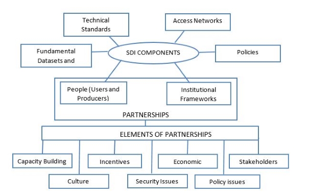
Figure 1: Conceptual Partnership for SDIs in
Developing Countries
The illustration in figure 1 is meant to reveal that SDI partnerships
can be premised on two SDI components, namely people and institutional
frameworks as a linkage between other SDI components and various
elements of system development. In that case, figure 1 highlight the
importance of partnerships in building SDIs whereby roles could be
identified in which stakeholders can partake for a successful SDI
initiative.
3.3 Conceptual SDI Partnership Framework Explained
It is necessary for organizations in developing countries to
acknowledge and recognize that there is value added in working with
other institutions. Therefore, figure 1 was constructed by considering
the six main components of SDI and then blocking the people and
institutions together to be the main components on which partnerships
are developable. A number of elements which can directly impact on
partnerships were then identified as shown on figure 1 and they include;
capacity building, culture, incentives, security issues, economic
issues, policy issues and stakeholders. Addressing the above elements
should lead to effective partnerships. Effective partnerships take time,
which requires all those involved to establish appropriate working
frameworks from the start. The structures and processes of the
partnerships evaluation as recommended by World Bank (1998) can be
followed. The partnerships advocated can start from small steps at
operational levels of organisations through management levels within an
organization up to inter-organizational. The operational level could be
involved in data production and dissemination, while the management
level could monitor the operational level as well as for decision making
and creating policies for conducive environments. It is important then
to discuss the elements of the partnership framework within the context
of underlying organisational behaviour, technical and information policy
issues.
3.4 Elements of the Partnership Framework
3.4.1 Capacity Building for SDI
Capacity building in an SDI context refers to improvements in the
ability of all stakeholders to perform appropriate tasks within the
broad set of principles of an SDI initiative. It involves the creation
and development of capacities and capabilities with efforts of solving
problems on spatial information collection, management, sharing and
dissemination. Capacity building does not only involve institutional
assessments and development, it also includes individuals. This is where
the importance of training in creating an enabling environment for SDI
development is realized. Extensive training for a successful SDI is an
essential and significant parameter of a functional partnership
framework. In agreement,
Williamson et al. (2003) stress that training requires a whole new way
of thinking about sharing and exchanging spatial data assets, and
creating optimum solutions that would benefit all partners.
According to Rajabifard (2002) there are different capacity building
factors that are necessary for the success of SDI initiatives. These
factors include technological capacity, human capacity and financial
capacity. Some examples of capacity factors cited by
Rajabifard and Williamson (2004)
include: the level of awareness of stakeholders on values of SDIs; the
state of infrastructure and communications; technological pressures; the
economic and financial stability of each member nation (including the
ability to cover participation expenses); the necessity for long term
investment plans; regional market pressures (the state of regional
markets and proximity to other markets); the availability of resources
(lack of funding, which could be a stimulus for building partnerships,
hence there should be a stable source of funding); and the continued
development of business processes.
Capacity building often focuses on staff development through formal
education and training programs to meet the lack of qualified personnel
in a project in the short term. However,
Rajabifard and Williamson (2004)
argue that capacity measures should be addressed in the wider context of
developing and maintaining institutional infrastructures in a
sustainable way. Moreover, businesses and decision makers should be made
aware of the benefits of having such an infrastructure so that there
could be investment and buy-in.
3.4.2 Culture
In the words of Kok and van Lonoen (2005) “SDI develops gradually”.
This statement need to be embedded into the organizational cultures in
SDIs of developing countries. Leadership of institutions need to be
visionary about this gradual process. Institutional leaders need to
understand that SDIs are better achieved with shared resources than as
individuals working in silos. A culture that lacks the appreciation that
more could be achieved as a collective, is common in developing
countries. Furthermore, the lack of awareness amongst stakeholders on
how they could effectively participate in the initiative is a stumbling
block in many developing countries. In addition, most organizations are
spatial data users and not producers. Users tend to concentrate on their
organizational needs and lack the hindsight that their information when
shared and integrated with others could bring value added products for
the benefit of all. This is supported by Warnest et al (2003) who have
indicated that “implementation of this type of infrastructure will be
facilitated through better understanding and awareness of the
partnerships that support SDI”.
3.4.3 Information Policy Issues
SDIs involve organizations and people sharing fundamental datasets
and services with each other (Rajabifard et al, 2003; Warnest et al,
2003; Hjelmager et al, 2008). However, with the absence of information
policies, procedures and rules that govern and guide
inter-organizational interaction, initiatives like SDIs may fail
terribly. It is necessary for coordinating agencies to clearly address
the issue of policies to all stakeholders involved. This is consistent
with the SDI information viewpoint where policy is recognised as the
starting point and a basis of shaping product specifications (Hjelmager
et al, 2008). Policies should also inform the preparation of guiding
principles for spatial data access, use and pricing models. Furthermore,
they should include legal implications for wrongful handling of
resources in the initiative, to curb abuse and encourage accountability.
These policies if properly implemented, could facilitate easy and
equitable access to spatial data and services. Policies should further
emphasize on maximizing net benefits with less variations on data
pricing and access policies between different stakeholders
(Clarke et al., 2003). In a
nutshell, stakeholders should develop policies that formalize and
legally bind partnerships, clarify participants’ roles and expectations,
such that a conducive SDI development environment is achieved.
3.4.4 Economic factors
Developing countries are known to have budgetary constraints due to
their low economic factors. As such, initiatives like SDIs are best
suited to such environments because a pool of shared resources can
provide more results at minimal cost for organizations involved.
Unfortunately, this has not been the case in most African countries. The
limited resources that developing countries have should be motivation
towards efficient and effective data sharing efforts. In addition, there
should be clear SDI directives and funding mechanisms, as these have
proved to be detrimental in establishing successful initiatives in
western countries like the USA and Canada. Such funding mechanisms can
only be achieved if the limited resources are channelled to where they
are most needed.
Developing countries tend to embrace proprietary software suites more
than free and open source software suites (FOSS). They believe that
proprietary suites have more support compared to FOSS. However,
technological advancements like the Internet, GitHub (a Web-based
development platform for FOSS), and question and answer websites (e.g.
GIS Stack Exchange and Stack Overflow) have made it possible for FOSS
development codes, strategies and documentation to be available to
everyone. Current investments made by developing countries in
proprietary software suites that are pricey and unsustainable, could be
channelled into other resources like improved data collection tools. In
addition, geoprocessing needs and adequate utilization of advanced
software suites in developing countries are very low and these could be
performed sufficiently by FOSS. Hence, the justification that ample
resources are misplaced in tools that do not meet the needs of users.
The adoption of standards in an SDI environment, could enable users and
producers to share spatial data and resources regardless of the software
suite used.
3.4.5 Security Issues
SDIs deal with many stakeholders in a distributed network. They
involve the use of spatial data and resources from a variety of
stakeholders with different needs and purposes like spatial analysis,
optimum route analysis, geoprocessing and other decision-making
activities. Therefore, it is essential that data and services in the
initiative are produced by trusted and properly registered sources.
Enforcing security within the SDI environment can also help attract more
users and producers into the initiative over time. Sufficient security
measures could further increase the integrity of the initiative, thus
attract more organizations to it including late adopters. Other avenues
to increase the integrity of the initiative include: a) upholding
technical standards, b) conducting regular updates of spatial data and
services, c) encouragement of partnerships for value added information,
d) establishing proper monitoring and security measures to ensure that
it is free from virus attacks and abuse, and e) ensuring that only
registered users benefit the most from the initiative.
3.4.6 Incentives
Partnerships are meant to benefit all those involved, hence the need
to identify areas where each participant may benefit from the initiative
is imminent. For all stakeholders involved, a return on investments
study should be conducted for each stakeholder to promote their buy-in.
An example cited by
Borzacchiello and Craglia
(2013), is that organizational structures of each stakeholder could be
inspected and in-depth case studies conducted to gather more information
for better placement into the initiative. However, it should be noted
that initiatives like SDIs may take longer for individual stakeholders
to realize financial benefits, but added value products from utilizing
spatial data from various sources may be achieved. Due to the complex
nature of SDI partnerships,
Rajabifard et al. (2002) suggest
that they should be positioned such that they develop as the SDI
progresses. The authors highlight that users and businesses should drive
the development of SDIs, which in turn will lead to business systems
relying on the infrastructure. Eventually the initiative could become an
infrastructure of successive business systems
(Rajabifard et al., 2002).
3.4.7 Stakeholders
Successful SDI implementations in developed countries have clear
defined roles and responsibilities of stakeholders in their initiatives.
They have a coordinating agency and leading organizations in each
jurisdiction responsible for coordinating efforts in that area. Such an
arrangement helps create an environment of accountability and trust
between stakeholders. Furthermore, it increases stakeholder awareness of
spatial data in the community where proper communication channels can be
used to disseminate it to other stakeholders to reduce duplication of
effort.
Institutions can have their own systems that meet their own needs,
but an infrastructure environment can only be achieved if they are made
interoperable through agreed standards and technical specifications.
This is where the significance and importance of partnerships come into
place. It is necessary for member states to assess the impacts that each
organization’s investment may have in the infrastructure
(Borzacchiello and Craglia,
2013). For example, conducting early impact assessment activities like
that of INSPIRE in 2003-04 where a programme of activities was launched
to practically verify cost and benefit assumptions of the initiative
(Borzacchiello and Craglia, 2013). Rather than being theoretical in all
aspects, some avenues within the infrastructure could be validated in
such a manner at the initial implementation stages.
4.0 A CASE FOR AFRICAN COUNTRIES
Among developing nations, African countries have made their own
efforts towards SDI and some levels of assessment have been carried
based on Inspire State of Play method (Makanga and Smit 2010) and SDI
Readiness Index (Mawange, Maluku and Siriba, 2016). In Makanga and Smit
(2010) where 29 countries were assessed, several elements which are
cornerstones to SDI development were found not to be satisfactory. These
include; coordination, political support, funding and stakeholder
participation. All these elements do bear the hallmarks of SDI
partnerships which if sufficiently promoted and implemented, can produce
positive results. Within a period of six years from Maknga and Smith
assessment a SDI Readiness Index assessment was carried out by Mwange et
al (2016) and the extracted results of the study, presented in tabular
form are shown in Figure 2.
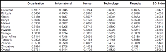
Figure 2: Extract of SDI Readiness Index (Source:
Mwange, Maluku and Siriba 2013)
The SDI readiness Index as depicted in Figure 2 indicate a minimum of
0.33 to a maximum of 0.69. These indices imply that more work needs to
be done and this paper proposes partnerships that should be utilised to
close gaps inhibiting SDI developments in these countries. From the
presented results, organisations and informational elements indices are
very low which could be attributed to weak institutional partnership
arrangements to move SDI forward. The two examples of assessments
carried in Africa by two different researchers using two different
methods suggests strongly that partnerships could be a real problem in
SDI development. Some countries like Botswana, Ethiopia, Kenya, Malawi,
Nigeria, Rwanda, Senegal, South Africa, Tanzania and Zimbabwe are
featuring in both assessments. It is a concern that some of these
countries are still returning readiness indexes which are routinely
described by Mwange et al (2013) as “a lot more work still needs to be
done”.
5. CONCLUSION
Developing countries have in the past struggled to establish SDI
initiatives because of issues that this paper has highlighted in the
conceptual partnership framework outlined. This research argues that SDI
implementations in developing countries can be as successful as those in
developed nations. However, there are some aspects regarding
partnerships that impede developing countries to establish successful
SDI implementations. These failures are attributed to a lack of
understanding and appreciation of how stakeholders can actively
collaborate in partnerships for a successful initiative that benefits
all parties. Therefore, this research has developed a conceptual
framework that highlights an enabling platform where stakeholders can
actively collaborate in the collection, sharing, storage and
dissemination of spatial data. The conceptual framework highlights
issues that developing countries should consider in their efforts to
building functional partnerships for successful SDI implementations. It
is believed that the issues raised and suggestions outlined in this
partnership framework could aid the implementation of a successful
initiative. This paper has put forward a partnerships framework for
consideration in SDI development and made relations to several
assessments carried out on the African continent. Building spatial data
through the power of the functional partnership framework can help
address the following problems; Common geodetic reference framework,
records linking, sharing and data exchange between stakeholders, removal
or reduction of data inconsistencies, cumbersome data presentation and
record keeping, lack of standards in spatial data handling, production
of fit for purpose spatial data products and reduction of
geo-information transaction costs. Future work will further investigate
the proposed conceptual partnerships elements and actually test them in
some African countries by basing then on the preceding mentioned
problems.
REFERENCES
- Bishop, I. D., Escobar, F. J., Karuppannan, S., Suwarnarat, K.,
Williamson, I., Yates, P. M. & Yaqub, H. W. 2000. Spatial Data
Infrastructures for Cities In Developing Countries: Lessons From The
Bangkok Experience. Cities, 171, 85-96.
- Borzacchiello, M. T. & Craglia, W. 2013. Estimating Benefits of
Spatial Data Infrastructures: A Case Study On E-Cadastres.
Computers, Environment and Urban Systems Journal, 41, 276-288.
- Budhathoki, N. M., (Chip) Bruce B., & Nedovic-Budic, Z. 2008.
Reconceptualizing the role of the user of spatial data
infrastructure. GeoJournal, Vol. 72, No. 3/4, pp. 149-160.
- Clarke, D., Hedberg, O. & Watkins, W. 2003. Development of The
Australian Spatial Data Infrastructure, London, Taylor And Francis.
- Coleman, D. 2010. Volunteered Geographic Information in
Spatial Data Infrastructure: An Early Look at Opportunities and
Constraints. GSDI 12 world conference, Singapore.
- Craglia, M. & Annoni, A., 2006. INSPIRE: An Innovative Approach
to the Development of Spatial Data Infrastructures in Europe.
GSDI-9 Conference Proceedings, 6-10 November 2006, Santiago, Chile
Research and Theory in Advancing Spatial Data Infrastructure
Concepts.
- Crompvoets, J., Rajabifard, A., Van Loenen, B. & Tatiana, D. F.
2008. A Multi-View Framework to Assess Spatial Data Infrastructures,
Melbourne, Australia., The Melbourne University Press.
- Dutta, S. and Wiess, A. M. 1997. The Relatioship Between a
Firm's aTechnological Innovativeness and its Pattern of Partnership
Agreements.Managment Science, Vol. 43 No. 3, 343-356.
- Ettlie J. E. and Pavlou, P. A. 2006. Technology-Based New
Product Development Partnerships. Decision Sciences, Volume 37
Number 2, 117-147
- Elwood S. 2008. Grassroots groups as stakeholders in spatial
data infrastructures: challenges and opportunities for local data
development and sharing. International Journal of Geographical
Information Science Vol. 22, No. 1, 71–90.
- Fernandez, T. D., Lance, K., Buck, M. & Onsrud, H. J.
2005. Assessing an Sdi Readiness Index. From Pharaohs To
Geoinformatics, 2005 Cairo, Egypt. Fig Working Week 2005 And Gsdi-8,
1-10.
- Geoconnections, 2013. Spatial Data Infrastructure (SDI) Manual
for The Americas. Available From:
Http://Unstats.Un.Org/Unsd/Geoinfo/Rcc/Docs/Rcca10/E_Conf_103_14_Pcidea_Sdi%20manual_Ing_Final.Pdf
[Accessed 3 Oct 2017]
- Georgiadou, Y., Puri, S. K. & Sahay, S. 2005. Towards a
Potential Research Agenda to Guide the Implementation Of Spatial
Data Infrastructures – A Case Study From India. International
Journal Of Geographical Information Science, 19, 1113-1130.
- Hjelmager J., Moellering H., Delgado T., Cooper A., Rajabifard
A., Rapant P., Danko D., Huet M., Laurent D., Aalders H., Iwaniak
A., Abad P., Düren U. and Martynenko A. (2006). An Initial Formal
Model for Spatial Data Infrastructures. ICA Spatial Data Standards
Commission. International Journal of Geographical Information
Science Volume 22, Issue 11-12. From URL:
DOI:10.1080/13658810801909623.
- Harvey F., & Tulloch D., (2006). Local-Government Data Sharing:
Evaluating the Foundations of Spatial Data Infrastructures.
International Journal of Geographical Information Science Vol. 20,
No. 7, 743–768.
- Janowicz K., Schade S., Arne Bröring A., Keßler C., Maué P., &
Stasch C. (2010). Semantic Enablement for Spatial Data
Infrastructures. Blackwell Publishing Ltd, Transactions in
GIS, 14(2): 111–129.From: doi:
10.1111/j.1467-9671.2010.01186.x [Accessed 29 Sept 2017].
- Kok, B. and van Loenen, B. 2005. How to assess the success
of National Spatial Data Infrastructures? Elsevier, Computers,
Environment and Urban Systems 29 (2005) 699–717.
- Lipeg, B. 2010. Future Challenges for Surveyors in Developing
European and National Societies :- Nmca Point Of View [Online].
Available:
Http://Www.Clge.Eu/Documents/Events/2/18_S_1_En.Pdf [Accessed 14
April 2011].
- Lipeg, B. & Modrijan, D. 2010. NSDI in The Context Of Inspire -
Slovenia’s State Of The Art And Private Sector Challenges.
International Conference Sdi, 2010 Skopje, Macedonia. 1-19.
- McLaughlin, H. (2004). Partnerships: Panencea or Pretence?
Journal of Interprofessional Care, VOL. 18, NO. 2, 104-113.
- Makanga, P. & Smit, J. 2010. A Review of The Status of Spatial
Data Infrastructure Implementation in Africa. South African Computer
Journal, 45, 18–25
- Maphale, L. & Phalaagae, L. (2012). National Spatial Data
Infrastructure in Botswana – An Overview. CSCanada Advances in
Natural Science Vol. 5, No. 4, 2012, pp. 19-27.
DOI:10.3968/j.ans.1715787020120504.1953.
- Morebodi, B. H., 2001. Botswana – Towards a National Geo-Spatial
Data Infrastructure. International Conference on Spatial
Information for Sustainable Development, 2-5 October 2001 2001
Nairobi, Kenya. 1-8.
- Moreri, K., Fairbairn, D. & James, P., 2016. Establishing the
Quality and Credibility of Volunteered Geographic Information in
Land Administration Systems in Developing Countries. GIS Research
UK, 24th Annual Conference, GISRUK, University of Greenwich, London.
- Mueller, H. 2010. Spatial Information Management, an Effective
Tool to Support Sustainable Urban Management. URL:
Http://Www.Isocarp.Net/Data/Case_Studies/1654.Pdf [Accessed 13
Sept 2017].
- Mwange, C., Mulaku, G.C., & Siriba, D.N. 2016. Reviewing the
Status of National Spatial Data Infrastructures in Africa. Survey
Review, Taylor And Francis Group. From Url:
Http://Dx.Doi.Org/10.1080/00396265.2016.1259720 [Acessed 1 Oct
2017].
- Nebert, D. D. 2004. The SDI Cookbook. Global Spatial Data
Infrastructure, 2, 171.
- Onah, C. C. 2009. Spatial Data Infrastructures Model for
Developing Countries – A Case Study of Nigeria. Msc, Westfaelische
Wilhelms Universitaet.
- Rajabifard, A. 2002. Diffusion for Regional Spatial Data
Infrastructures: Particular Reference to Asia and the Pacific. Phd,
The University Of Melbourne.
- Rajabifard, A., Feeny, M. F. & Williamson, I. P. 2002. Future
Directions of SDI Development. International Journal of Applied
Earth Observation and Geoinformation, 4, 11-22.
- Rajabifard A, Feeney M F, and Williamson I. 2003. Spatial Data
Infrastructures: Concept, nature and SDI hierarchy. In Williamson I,
Rajabifard A, and Feeney M F (eds) Developing Spatial Data
Infrastructures: From Concept to Reality. Boca Raton, FL, CRC Press:
17–40
- Rajabifard, A. & Williamson, I. 2004. SDI Development And
Capacity Building. Proceedings of the 7th GSDI Conference, 2-6
February 2004 Bangalore, India.
- Vandenbroucke D., Janssen K., & Van Orshoven, J. 2008. INSPIRE
State of Play: Generic approach to assess the status of NSDIs.
In:J.Crompvoets, J. Rajabifard, B. Van Loenen and T.D.Delgado
Fernandez (Eds). A Multi- view framework to assess Spatial Data
Infrastructures Multi-view framework to assess SDIs pp.11-22. Space
for Geoinformation, Wageningen University and Centre for SDIs and
Land Administration University of Melbourne.
- Vandenbroucke, D., Crompvoets, J., Vancauwenberghe, G., Dessers,
E., & Van Orshoven, J. (2009). A network perspective on spatial data
infrastructures: application to the sub-national SDI of Flanders
(Belgium). Transactions in GIS, 13(s1), 105–122.
- Warnest, M., Rajabifard, A. & Williamson, I. 2003. Understanding
Inter-Organisational Collaboration and Partnerships in the
Development of a National SDI [Online]. Available:
Http://Www.Undp.Org.Cu/Eventos/Espacial/Urisapaper_Warnest.Pdf
[Accessed 24 Sept 2017].
- Williamson, I., Rajabifard, A. & Enemark, S. 2003.
Capacity Building for SDIs. Proceedings of 16th United Nations
Regional Cartographic Conference for Asia and The Pacific, 14-18
July 2003 Okinawa, Japan.
- World Bank 1998. World Bank Partnerships Group, Strategy and
Resource Management In: Bank, P. F. D. P. A. F. T. W. (Ed.)
BIOGRAPHICAL NOTES
Lopang Maphale is a PHD Candidate at the University
of Cape Town in South Africa. He is a Lecturer of geomatics at the
University of Botswana where he is currently on study leave. He is a
Registered Professional Land Surveyor and has MSc in GIS, MBA and
BSc(Hons) in Surveying and Mapping Sciences. He is the former President
of Botswana Surveying and Mapping Association and regular Botswana
representative at FIG. His research in geomatics is in spatial data
infrastructures, modern geospatial technologies, land administration and
geospatial information management in developing economies.
Kealeboga Kaizer Moreri is a PhD student at
Newcastle University, UK. He is a staff development fellow in geomatics
at the University of Botswana where is currently on study leave. He
holds an MSc in Geomatics Engineering from the University of New
Brunswick, Canada and a Bachelor of GIS from the University of South
Australia, Australia. His research interests are in geomatics, spatial
data infrastructure, volunteered geographic information and land
administration.


