Article of the Month -
September 2006
|
Issues in the Governance of Marine Spaces
Dr. Michael SUTHERLAND and Dr. Sue NICHOLS, Canada
|

Michael Sutherland |

Sue Nichols |
 This article in
.pdf-format
This article in
.pdf-format
1) This paper is the introduction chapter of FIG publication
“Administering Marine Spaces: International issues”. This publication is
result of FIG Commissions 4 & 7 Working Group 4.3. FIG publication 36,
Copenhagen 2006, ISBN 87-90907-55-8.
Abstract
Good governance is based on recognition of the interests of
all stakeholders and inclusion of their interests where possible. Interests
can be expressed in a variety of ways, for example: sovereignty,
jurisdiction, administration, ownership (title), lease, license, permit,
quota, customary rights, aboriginal rights, collective rights, community
rights, littoral rights, public rights, rights of use, and public good.
Coastal states are challenged with managing the multidimensional tapestry of
these interests (and perhaps others) in the coast and offshore. Over the
next few decades those responsible for marine policy and administration have
been challenged with trying to understand this tapestry and communicating it
to the various decision makers and stakeholders. However, addressing the
complexities associated with these interests solely from a boundary
delimitation perspective does not necessarily improve the governance of
marine spaces. This paper explores a number of legal, technical, and
stakeholder issues related to governing marine spaces.
1. INTRODUCTION
The governance of any geographical area, including marine
spaces, is actually the management of stakeholder relationships with regard
to spatial-temporal resource use in the pursuit of many sanctioned economic,
social, political, and environmental objectives. Good governance is based on
recognition of the interests of all stakeholders, and inclusion whenever
possible. Governance involves setting priorities that may establish
hierarchies of interests, but the basis is recognition of what is excluded,
as well as what is given priority in certain situations.
These interests can be expressed in a variety of ways, for
example: sovereignty, jurisdiction, administration, ownership (title),
lease, license, permit, quota, customary rights, aboriginal rights,
collective rights, community rights, littoral rights, public rights, rights
of use, and public good. One feature of being a coastal state is that there
is a multidimensional tapestry of these interests (and perhaps others) in
the coast and offshore. Marine administrators are challenged with trying to
understand and communicate this to the various decision makers and
stakeholders.
A marine cadastre, or other marine information management
system, serves to meet the information requirements for governance of marine
spaces by facilitating the management of thematic information and their
boundaries and limits. In past research we initially assumed that spatial
delimitation of interests would help clarify resource management and use
regime in marine spaces. What was learned from our research was that this
approach was very limited and probably impossible. The main reason is that
there are numerous marine boundaries, and four dimensions at least had to be
considered. Drawing lines on charts was often not feasible, legally valid
nor of value. The legal profession taught us that there were a myriad of
boundaries: at least one if not more for every resource and every resource
use. Starting from the boundary perspective was a nonstarter.
Effective governance of marine spaces requires that a number
of things need to be considered including:
-
the need for inclusion;
-
the need to change our concepts of a cadastre to deal with
multiple interests for the same space at the same time;
-
the difficulties in identifying, yet including, all the
stakeholders;
-
the importance of information, not necessarily precise
boundary delimitation;
-
the need to develop tools better than the traditional
cadastre to govern marine spaces effectively.
To address the listed considerations, this chapter will
explore the governance of marine spaces by focusing on a number of
stakeholder issues, legal issues, and technical issues. However what is
meant by governance will first be discussed.
2. GOVERNANCE
The governance of marine spaces is the management of
stakeholder activities in these spaces. To optimize this management and to
address stakeholder issues requires that effective governance frameworks be
in place. Collaborative, cooperative, and integrative governance are
improved frameworks for dealing with stakeholder issues. Traditional
governance models have been based on a management science approach where the
premise is that leadership of organizations (public, private or civic) is
strong, and have good understanding of their environment (future trends,
rules of the game, and the organization's goals) [Paquet, 1999]. As such,
the leaders provide direction for the groups they represent.
A hierarchical governance model is one such example. This
form of governance, usually practiced by the state or some other governing
authority, is usually enacted through policies, laws and regulations
[Hoogsteden, Robertson and Benwell, 1999; Paquet, 1999; Savoie 1999]. This
hierarchical model assumes a top-down approach is always best, whereas
subsidiarity (i.e., the principle based on the assumption that individuals
are better able to take care of themselves than any third party) might
alternatively provide a better solution in some circumstances. Subsidiarity
would support, for instance, the devolution of responsibilities to citizens
by provincial/state authority (or to states/provinces by federal authority)
as much as possible unless they were unable to manage [Rosell, 1999;
Chiarelli, Dammeyer and Munter, 1999].
The management science approach also assumes that
organizations are operating in "a world of deterministic, well-behaved
mechanical processes" [Paquet, 1999]. However, life is full of paradoxes,
contradictions, and surprises [Handy, 1996], so the management science
approach has been inadequate, continually faced with situations that are
ill-defined, uncertain, unstable, or unreliable. As a result of the failure
of the management science approach to governance to adequately handle all
the complexities of life, other models have been proffered. These models are
based on cooperation, coordination, collaboration, integration or other
principles of shared responsibilities. The similarities or overlaps in the
definitions of these models again underscore the absence of general
principles to help guide in the design of good governance structures
[Paquet, 1999]. Among these models are:
-
Distributed governance which is embedded in a set of
organizations and institutions built on market forces, the state, and
civil society, and which deprives the leadership of the exercise of
monopoly in the direction of the organization. [Paquet, 1999; Meltzer,
2000];
-
Co-governance (e.g. practiced on a state-civic level) that
comprises mutual organization by two or more involved groups [Charette and
Graham, 1999; Hoogsteden, Robertson and Benwell, 1999];
-
Triangle-wide governance that consists of the integration
of the three families of institutions (economy, society and polity) into a
sort of neural network [Paquet, 1999; Meltzer, 2000];
-
Transversal and meso-innovation systems of governance that
employ “consensus and inducement-oriented systems to achieve coordination
among network players” [Paquet, 1999];
-
Renaissance-style independency forms of governance that
utilize informal terms, and the devolution and decentralization of
decision-making to achieve its objectives [Paquet, 2000].
These models are by nature subversive to those
organizational structures based on traditional models of governance. They
challenge the view that an "omnipresent person or group has monopoly on
useful knowledge and can govern top down" [Paquet, 2000].
There are many definitions of governance. Some of these
include:
-
“The process whereby a society, polity, economy, or
organization (private, public or civic) steers itself as it pursues its
objectives” [Centre on Governance, 2000; Paquet, 1994; Paquet, 1997;
Rosell, 1999].
-
“The process of decision-making with a view to managing
change in order to promote people's wellbeing” [Kyriakou and Di Pietro,
2000].
-
“The set of processes and traditions which determine how a
society steers itself thereby according citizens a voice on issues of
public concern, and how decisions are made on these issues” [Meltzer,
2000].
-
“The guidance of national systems shared by ensembles of
organizations rooted in the three sectors (economy, polity, civil society
and community)” [deBlios and Paquet, 1998].
-
The means by which local, regional, national and
international communities organize themselves and subsequently respond to
issues of interest to members of those communities. It involves leadership
on the part of government and the use of policy and programs to control
and influence activities within communities [Manning, 1998].
A number of points essential to governance are alluded to in
the above definitions. Firstly, governance is all encompassing, touching
virtually every area of human existence. Secondly, governance can take many
forms, and takes place on many levels. This is supported by Masson and
Farlinger [2000]. Each form of governance makes use of facilitative
processes, mechanisms and systems to pursue goals. Thirdly, governance is
about the provision of direction towards the achievement of objectives. The
direction taken must take cognizance of the interests, rights,
responsibilities, and differences among all stakeholders.
3. STAKEHOLDER ISSUES
Practical problems in governance include:
-
how identify who the stakeholders are;
-
how to engage them effectively; and
-
how to manage their input, including keeping the dialogue
going over time.
This can be summarized as defining the governance process in
terms of liaising, listening, learning, and leading. Too often agencies
responsible for programs and projects focus only on the last step.
3.1 Stakeholder identification
One of the greatest limitations in most marine programs and
projects is having a narrow approach to stakeholder participation. This is
often driven by issues such as: time constraints, lack of knowledge, single
issue focus, or governmental silos. It is particularly true in coastal
region were there may be jurisdictional uncertainty, overlaps, and gaps.
However, the top down approach, while perhaps being the easiest to manage,
is also the least likely to have sustainable results. Spending time at the
local level in the initial stages of marine activities (e.g., through
workshops and town hall meetings) can help to identify the breadth of
stakeholders and their interests.
3.2 Effective Stakeholder Engagement
Effective consultation is not just “this is what we are
going to do for you.” Frequently, information meetings allow question
periods but do not include processes for taking and putting input to use. A
variety of means can be used to obtain input including web portals. The
information provided for consultation also has to have the right message and
medium for the variety of different audiences.
3.3 Managing Stakeholder Input
Once input is obtained, consensus building strategies are
required to establish priorities and identify appropriate solutions.
Frequently the priorities are different at the local, regional, and national
level. Whoever is leading also has to listen and learn if the differences
are to be accommodated or resolved. And this is an on-going process that
will effect the life of the governance activity.
The above may seem simplistic, but ignoring these issues can
undermine the best intentioned activities. Some examples in Canada include:
-
Significant delays in establishing a Marine Protected Area
(MPA) because a First Nation (aboriginal) group was excluded in the
initial discussions: The MPA program is led by the federal government
which has taken nearly ten years to recognize and understand the
importance of provincial, municipal, and private interests [Leroy, 2002].
-
Ineffectiveness of a provincial policy to limit coastal
development because of lack of trust at the local level despite numerous
“information” meetings: The result was that policy implementation was
delayed for 10 years and inappropriate construction increased in the
meantime to avoid the expected regulations [Nichols, et al., 2006].
-
Lack of comprehensive coastal zone management programs due
to uncertainty and fragmentation in jurisdiction, administration,
ownership, and use of coastal resources: There are not well established
arrangements for collaboration among all of the government agencies at the
several levels involved and each activity causes a new process of
stakeholder identification and consultation. From an information
perspective this has led to a lack of consistent data about interests and
boundaries along the coast.
4. LEGAL ISSUES
Another way of viewing marine governance is through an
analysis of governance functions that link governance to the law and
information. These include the following (Nichols, Monahan and Sutherland,
2000):
-
allocation of resource ownership, control, stewardship and
use within society;
-
regulation of resources and resource use (e.g.,
environmental protection, development and exploitation, rights to economic
and social benefits);
-
monitoring and enforcement of the various interests;
-
adjudication of disputes, including inclusive processes;
-
management of spatial (geographically referenced) and
other types of information to support all of the above functions.
This approach highlights the role of the legal frameworks
within each nation in managing marine space. These frameworks are generally
multi-layered ranging from the United Nations Law of the Sea Convention
(UNCLOS), international customary law, and international treaties to
national, state, and local level laws derived from tradition, legislation,
and the courts.
4.1 The Legal Complexity of Interests in Marine Space
The United Nations Law of the Sea Convention [UN, 1982]
establishes a framework for national and international governance by, among
other provisions, establishing limits of national resource use and control.
However, each nation must also have a set of procedures for allocating
resources within these zones. In many cases, this depends on tradition and
legal frameworks. These frameworks may be defined by the local, regional
(provincial/state) and/or national legal systems and constitutions. Even
when only government interests are considered, the resulting marine/coastal
legal arrangements are usually complex.
To illustrate this complexity, consider the following terms
often used interchangeably or inappropriately [Cockburn and Nichols, 2002]:
-
Sovereignty: supreme rights of ownership; entities
holding sovereign rights reserve the right to impose their will on others
and to usurp the ownership rights of others (e.g. by expropriation). In
international law, to be sovereign means that a state “must be able to
exercise jurisdiction, over a determinate tract of territory,...and have
legally independent powers of government, administration and disposition
over that territory.” [Walker, D, 1980].
-
Legislative Jurisdiction: “[t]he sphere of
authority of a legislative body to enact laws and to conduct all business
incidental to its law-making function.” [Black, 1979] or that aspect of
power where rules (i.e. rights, responsibilities and restrictions) of
social, cultural, economic and political behavior are defined, and wherein
it is determined how and when those rules are applied and enforced.
-
Administrative Authority: “[t]he power of an agency
or its head to carry out the terms of the law creating the agency as well
as to make regulations for the conduct of business before the agency;
distinguishable from legislative authority to make laws.” [Black, 1979].
It is therefore the means by which jurisdictionally defined rules are
applied and enforced.
-
Title or Ownership: the means whereby the owner of
the rights to the object of property has the just possession of that
object (although actual possession or occupation may be by another). Where
sovereign, jurisdictional, and administrative rights are normally rights
vested in governments and their agencies, title may be held by different
levels of government, groups, and individuals. Depending on the legal
system, ‘ownership’ may be full or partial and usually consists of
derivative interests (e.g., lease, use, license, mortgage).
4.2 The Specific Nature of Marine Interests
In theory, land and marine spaces both have this complex
legal regime. However, three characteristics of marine interests make the
complexity more apparent:
-
The legal frameworks are evolving rapidly and therefore
can be incomplete and contain more uncertainty than on land: Although
property and other related law always evolves on land, over the last
century, marine legal frameworks have been changing more rapidly. Causes
include:
-
expansion of national territories under the Law of the
Sea (and consequent boundary and limit delimitation issues);
-
need to clarify intergovernmental title, jurisdiction,
and administration within these expanded territories;
-
rapid development of relatively new marine resource uses
or increasing intensity of existing uses (e.g., petroleum and mineral
exploitation and transportation, coastal development, recreation and
tourism, aquaculture and sea ranching, renewable energy production);
-
emergence of new issues such as conservation and
environmental risk reduction;
-
increasing recognition of the rights of indigenous
groups and other groups in coastal and marine resource.
-
There are virtually no rights of exclusive use or
ownership in marine space: The three dimensional aspect of ‘a parcel’ is
more apparent (Figure 1) than on land because rights are usually allocated
for specific portions (e.g., seabed, water column) or specific activities
(e.g., fishing, navigation). The interests usually coexist and even this
coexistence may change over time (e.g., seasonal rights). This increases
the number of stakeholders that must be considered for any marine/coastal
area. It also results in myriad boundaries of jurisdiction,
administration, ownership and use – in some instances, a boundary or limit
for each specific resource or activity.
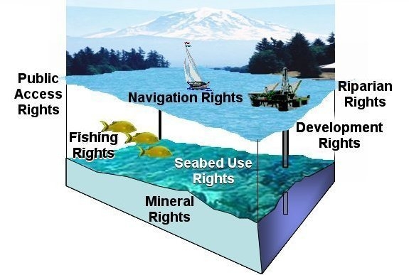
Figure 1: 3-Dimensional Marine Parcel
(From Sutherland [2005])
-
Interests in marine space tend to come in smaller
‘packages’: Related to the first point is the fact that the management of
marine interests tends to focus on specific resources or activities rather
than geographic areas. On land, for example, we package spaces as:
-
state land vs. private land;
-
federal land vs municipal land;
-
exclusive rights of surface ownership such as freehold,
which include fixtures (e.g., trees, buildings, and at least some
subsurface rights).
This fragmentation of interests is also usually reflected in
(or caused by) the institutional structures of government. Thus the Ministry
of Fisheries may administer an area of marine space for fishing and related
activities and the same space is subject to different regulations for
navigation that is regulated by the Ministry of Defense. One result is the
fact that information about the stakeholders, their interests, and
activities is widely scattered throughout government.
4.3 The Elusive Land-Water Interface
Much of marine activity is focused on the coast. Similarly,
the intensity of land use in many countries is greatest at the coast in
large part because of traditional transportation and shipping through ports.
The result is that the number of stakeholders, the opportunities for
conflict among their interests, and the value they or society places on
those interests is at a maximum at the coastline. This results in and is
affected by the following issues, among many others:
-
Overlaps and gaps: There are often overlaps of
jurisdiction, administration, and ownership between government bodies that
are primarily land based and those that are marine based (e.g., in ports
where land and marine activities are intertwined). One consequence is that
information about those interests may not only be fragmented but also
inconsistent and incomplete;
-
Complex private and public interests: Private land
interests frequently extend into marine space (e.g., rights for wharf
development, littoral rights associated with upland ownership, traditional
rights to areas for fishing through weirs). In many cases these rights are
undocumented and have been acquired through traditional use. Furthermore,
these rights are not usually well understood by planners, managers, and
policy makers without a water law background. An additional complexity is
that there are emerging or increasing interests such as the public right
to access beaches and to have environmental protection of endangered
habitats. Such public interests typically clash with private interests,
and in many cases neither are well defined or documented.
-
Lack of appropriate information for traditional governance
practices: Information about coastal interests is generally not well
managed because, for example:
-
there are numerous government agencies involved
resulting in fragmented, duplicated, incomplete and inconsistent
datasets;
-
historical datasets are often incomplete and out of date
because there was little concern until recently;
-
no one agency (and in some cases no specific level of
government) has the responsibility to lead data management activities in
both coastal land and marine spaces.
-
Boundaries and limits are not well delimited: Boundaries
and limits in the coastal zone are typically made with reference to
physical features, many of which are difficult to clearly define or
relocate (e.g., high water, the shoreline, the normal baseline). The land
water interface is ambulatory and traditionally most boundaries and limits
followed the motions of that interface. Today greater emphasis is placed
on ‘fixing’ these lines. This may be driven by law (e.g., nations
generally declare their national baselines under the Law of the Sea at a
point in time for offshore boundary delimitation); by institutional
structure and practice (e.g., the municipal coastal boundaries defined on
a map); or by technology (e.g., the desire to establish co-ordinates or
boundaries for geographical information systems). However, for the most
part, the law only delimits boundaries when, and if, an issue arises.
Therefore without court decisions or specific legislation the location of
many boundaries is a matter of considerable interpretation [Sutherland,
2005].
5. TECHNICAL ISSUES
5.1 The importance of information
Information is an essential technical component of the
governance of marine spaces. Information on resources that currently exist,
the nature of the environment within which those resources exist, as well as
on the users and uses of those resources is always a requirement for
effective evaluation and monitoring of marine areas. Information on, for
example, living and non-living resources, bathymetry, spatial extents
(boundaries), shoreline changes, marine contaminants, seabed
characteristics, water quality, and property rights can all contribute to
the sustainable development and good governance of coastal and marine
resources. All of these types of information have spatial components and
therefore spatial information is important to the good governance of marine
spaces (Figure 2) [Sutherland, Wilkins and Nichols, 2002].
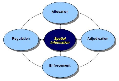
Figure 2: The role of spatial
information in governance
(From Nichols, Monahan and Sutherland, 2000)
Boundary information is one type of spatial information that
is essential in the management and administration of marine spaces. However
in some cases it may be better not to focus on boundaries, as boundary
uncertainties (e.g., as with federal and provincial boundary uncertainties
in some coastal regions in Canada) are sometimes the cause of social and
administrative conflicts in coastal and marine spaces. Recent governance
research supports the relevance of imprecise or ill-defined boundaries
insofar as the existence of these boundaries is not a catalyst for dispute
[Nichols, Monahan and Sutherland, 2000]. The precise delimitation of
boundaries usually become important in relation to the need to allocate
equitable resources perceived to be dissected by the potential boundary
[Hildreth and Johnson, 1983]. For example, such is the case with the
boundary dispute between Nova Scotia and Newfoundland [Arbitration Tribunal,
Nova Scotia-Newfoundland Dispute, 2002].
5.2 The issue of four-dimensional rights in marine spaces
When considering marine environments from a right-based
perspectives, one ought to consider that in one column of the marine
environment there are rights to the surface of the water column (e.g.
navigation), to the water column it self (e.g. fishing), to the seabed (e.g.
fishing and mineral resources), and to the subsoil (e.g. mineral resources).
The very nature of the marine environment requires that rights be considered
in terms of at least three dimensions, in snapshot, and more practically in
four dimensions considering that rights to marine spaces change over time.
Technically, therefore, tools developed to manage and administer rights to
marine spaces should consider the inherent multidimensional nature of those
rights [Ng’ang’a et al, 2004].
5.3 Dealing with multiple interests for the same space at
the same time
Concepts such as the marine cadastre or marine
administration systems have been discussed in many academic papers as
technical means for aiding in the management and administration of rights in
marine spaces. Any technical tool such as a marine cadastre or marine
administration system is faced with the challenges of not only dealing with
the multidimensionality of rights to marine spaces but also with the fact
that in many international jurisdictions there is the added complexity of
overlapping interests (e.g., jurisdictional rights, administrative rights,
title, leases, customary rights, aboriginal rights, public rights, etc.).
The design of marine information systems dealing with the management of
rights information ought to take the possibility of overlapping and
co-existing rights into consideration [Ng’ang’a et al, 2004].
5.4 Fitting into larger ‘information’ initiatives
The management of marine spatial information is an asset to
the efficient management of marine resources, and can in many instances help
to avoid minimize conflict among the many stakeholders. Recognizing this,
and the fact that no one stakeholder possesses all necessary information,
many jurisdictions have begun initiatives to better manage coastal and
marine spatial information and to apply information technology and concepts
to the management of marine spatial information [Ng’ang’a et al, 2004;
Nichols, Monahan and Sutherland, 2000].
In order to coordinate the dissemination of marine spatial
data that can support good governance of coastal and marine spaces, marine
geospatial data infrastructure initiatives are underway in many parts of the
world. Initiatives such as Canada’s Marine Geospatial Data Infrastructure
(MGDI) and the U.S. Federal Geographic Data Committee (FGDC) are considering
the information and other infrastructure components necessary to provide
geographically dispersed stakeholders with spatial data to support
governance decision-making. Regional bodies such as the Permanent Committee
on GIS Infrastructure for Asia and the Pacific (PCGIAP) are also taking
steps to implement marine geospatial infrastructures.
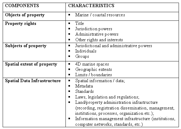
The components of any marine geospatial data infrastructure
are expected to include key spatial data, computer network infrastructures,
spatial data management software and other software, data- and other
standards, metadata, stakeholders, and possibly a spatial data
clearinghouse. Table 1 shows spatial data infrastructures as part of a
marine information system from a property rights perspective.
Table 1: Components of a Marine
Information System from a Property Rights Perspective
(After Sutherland, 2005)
5.5 Issues in defining coastline boundaries
Tidal boundaries along coasts in North America are defined
in law either by the “intersection of a specific tidal datum with the shore”
or by “tide marks left on the shore by the receding waters of a particular
stage of tide” [Nichols, 1983]. Internationally this is more or less true.
Because tidal datums are related to specific sea levels and therefore
subject to temporal and spatial variations, and because the marks left by
tidal actions on shores also vary with the changes in sea level and tides,
boundaries defined by these methods are sometimes subject to ambiguous
positioning in 3-dimensional space.
Constant tidal action against the shore can cause the
deposit of material on the shore or the erosion of shore material and
therefore the physical configurations of shorelines are subject to constant
change [Flushman, 2002; Lamden and de Rijcke, 1985; Nichols, 1983]. This
means that resurveys are sometimes necessary in order to keep coastal
boundary information up to date. These and other factors are issues in
defining coastline boundaries and therefore indirectly affect the governance
of marine spaces since, for example, the implementation of jurisdictional
and administrative rules and regulations often depend upon defined
boundaries.
5.6 Science and Local Knowledge
As on land, traditional or local knowledge can play an
important role in marine governance. Unfortunately the value of local
knowledge is not always appreciated or is ignored because: it is not
standardized; it is not considered ‘objective’; or it is difficult to
obtain. However science has only begun to give a picture of the vast ocean
territory, even near the coast. We have snapshots and sporadic data, which
like lead line depth measurements, leave much to be discovered and
understood. Local knowledge is an asset not to be underestimated in filling
in those gaps, validating the scientific sample and theories, or in
understanding the interconnection within ecosystems. Fishers along the East
and West Atlantic coasts, for example, could have advised the scientists who
helped governments who established fishing quotas in the 1970s-1990s that
many north Atlantic the fish stocks were declining, long before the science
driven government policies endangered the fishing resources.
6. DISCUSSION
Marine cadastres and other marine administration information
systems have been proposed as technical solutions to the management of
information about interests in marine resources in support of coastal and
ocean governance. It is easier to design such systems to be useful for
managing information on single activities or resource use (e.g., petroleum
leases) occurring in marine spaces. However, in order to be of maximum
benefit to the governance of marine spaces these information systems will
have to be able to manage and visualize information on multiple marine
resource interests that overlap in 3-dimensional space, and time. These
systems should also function in an environment of efficient and effective
governance and legal frameworks, and optimal institutional arrangements that
meet the often diverse needs of identified and engaged stakeholders.
Therefore, we would like to propose that activities affecting the rights and
responsibilities, including information management, need to consider the
following:
-
A multidisciplinary approach is needed in the governance
of marine spaces. Surveyors, lawyers, planners, and resource managers all
understand part of the picture. To be complete or even useful, any
information system to support marine governance needs to reflect the
variety of interests, their complexity, and the unique aspects of marine
interests.
-
The emphasis should not necessarily on precise boundary
delimitation. Many of the boundaries and limits are undefined or
un-delimited until an issue arises. Others are fuzzy or moveable by nature
and best serve the interest of stakeholders that way.
-
The sheer number of overlapping and coexisting interests
in four dimensional space means that new approaches to presenting
appropriate information are needed. Rather than imposing a land-based
system (i.e., grids, straight lines and co-ordinates), the focus should be
on helping stakeholders and decision makers visualize the complexity and
multiplicity of interests.
-
Co-management arrangements may be a better option than
management of zones and geographical areas defined by boundaries if
governance is to be inclusive and recognize all interests. Co-management
(e.g., networking of information sources) will also be necessary in
developing truly useful information systems, rather than a single agency
approach.
The oceans provide an opportunity to not make the same
mistakes we have made in land resource management and land information
systems. Perhaps what we can create for marine space can help to improve our
governance and information systems on land.
REFERENCES
Arbitration Tribunal, Nova Scotia-Newfoundland Dispute
(2002)
http://www.boundary-dispute.ca/. Accessed March 2002.
Black, H. C. (1979). Black’s Law Dictionary Fifth Edition,
by Henry Campbell Black (5th Ed. By the Publisher’s Editorial Staff), West
Publishing Co., St. Paul, Minn. 1979.
Charette, N. and A. Graham (1999). "Building partnerships:
Lesson learned." In Optimum, Vol. 29, No. 2/3.
Chiarelli, B., M. Dammeyer and A. Munter (1999). "Why
regions matter: Perspectives from Europe and North America". In Gouvernance,
No. 1, March.
Cockburn, S. and S. Nichols (2002). “Effects of the Law on
the Marine Cadastre: Title, Administration, Jurisdiction, and Canada’s Outer
Limit.” Proceedings of the FIG Congress, Washington DC, USA, April 24, 2002.
DeBlois, P. and G. Paquet (1998). "APEX Conference 1998:
reflections on the challenges of governance." In Optimum, Vol. 28, No. 3,
pp. 59-69.
Flushman, B. S. (2002). Water Boundaries: Demystifying Land
Boundaries Adjacent to tidal or Navigable Waters. Wiley Series in Surveying
and Boundary Control.
Handy, C. (1996). "Finding sense in uncertainty." In
Rethinking the Future: Rethinking business, principles, competition, control
& complexity, leadership, markets and the world. Reprinted (1997). Ed.
Gibson, R., Nicholas Brealey Publishing, London.
Hildreth, R. and R. Johnson (1983). Ocean and Coastal Law.
Prentice-Hall, Inc., New Jersey.
Hoogsteden, C., B. Robertson, G. Benwell (1999). "Enabling
sound marine governance: Regulating resource rights and responsibilities in
offshore New Zealand." In Proceedings of the New Zealand Institute of
surveyors & FIG Commission VII conference & Annual General Assembly, October
9-15.
Kyriakou, D. and G. Di Pietro (2000). "Editorial." In The
IPTS Report, No.46, June 2000.
Lamden, D. W. and I. de Rijcke. (1989). “Boundaries.” In
Survey Law in Canada: A collection of essays on the laws governing survey of
land in Canada. The Canadian Institute of Surveying and Mapping; Canadian
Council of Land Surveyors; Carswell Toronto • Calgary • Vancouver
Leroy, A.S. (2002). "Public Participation and the Creation
of a Marine Protected Area at Race Rocks, British Columbia". Masters of
Science in Planning Thesis, School of Community and Regional Planning,
University of British Columbia, 137pp.
Manning, E. (1998). "Renovating governance: lessons from
sustainable development." In Optimum, Vol. 28, No. 3, pp. 27-35.
Masson, C. and S. Farlinger (2000). " First nations
involvement in oceans governance in British Columbia." Paper presented at
Coastal Zone 2000 conference, Saint John, NB, September.
Meltzer, E. (2000). "Oceans governance: A paradigm shift or
pipe dream?" Paper presented at Coastal Zone 2000 conference, Saint John,
NB, September.
Ng'ang'a, S. M., M. Sutherland, S. Cockburn and S. Nichols
(2004). "Toward a 3D marine cadastre in support of good ocean governance: A
review of the technical framework requirements." In Computer, Environment
and Urban Systems, 28 (2004), pp. 443-470.
Nichols, S. (1983). “Tidal Boundary Delimitation.” Technical
Report # 103, Department of Geodesy and Geomatics Engineering, University of
New Brunswick, Canada.
Nichols, S., D. Monahan and M. D. Sutherland (2000). "Good
Governance of Canada’s Offshore and Coastal Zone: Towards and understanding
of the Maritime Boundary Issues." In Geomatica, Vol. 54, No. 4, pp. 415-424.
Nichols, S., O. Chouinard, H. Onsrud, M. Sutherland, and G.
Martin [2006]. “Adaptation Strategies” Section 4.8 in Impacts of Sea-Level
Rise and Climate Change on the Coastal Zone of Southeastern New Brunswick,
R. Daigle, ed., Environment Canada (in press).
Paquet, G. (1994). "Reinventing Governance." In Opinion
Canada, Vol. 2, No. 2, April.
Paquet, G. (1997). "Alternative service delivery:
Transforming the practices of governance." In Alternative Service Delivery:
Sharing governance in Canada. Eds. Ford, R. and D. Zussman, KPMG • The
Institute of Public Administration • University of Ottawa Libraries.
Paquet, G. (1999). Governance Through Social Learning.
University of Ottawa Press.
Paquet, G. (2000). "Subsidiarity is an ugly but powerful
design principle." In The Hill Times, Ottawa, October 2nd
Rosell, S. A. (1999). Renewing Governance: Governing by
learning in the information age. Oxford University Press.
Savoie, D. J. (1999). Governing from the Centre: The
concentration of power in Canadian politics. University of Toronto Press.
Sutherland, M. D. (2005). “Marine Boundaries and the
Governance of Marine Spaces”. Ph.D. Dissertation (University of New
Brunswick) and University of New Brunswick technical paper, 2005.
Sutherland, M. D., K. Wilkins and S. Nichols (2002).
"Web-Geographic Information Systems and Coastal and Marine Governance." In
Optimum, Issue 3, Spring 2.
United Nations (1982). United Nations Law of the Sea
Convention. New York: UN.
Walker, D.M. (1980). The Oxford Companion to Law. Oxford:
Clarendon Press.
BIOGRAPHICAL NOTES
Dr. Michael Sutherland is a graduate in land
information management from the Department of Geodesy and Geomatics
Engineering, University of New Brunswick, Canada. He is currently engaged in
marine environment-related research activities at the School of Management,
University of Ottawa and Department of Oceanography, Dalhousie University,
Canada. He lectures part-time at Ryerson University, Canada. Michael is a
member of the Canadian Institute of Geomatics, and is Chair of the
International Federation of Surveyor’s Working Group 4.3, Commission 4
(hydrography, coastal zone management, ocean governance, and marine
cadastre).
Dr. Sue Nichols is a Professor in Land Administration
and Property Studies at the University of New Brunswick and has conducted
research on tidal and marine boundaries for over 20 years. Sue is a
Past-President of the Canadian Institute of Geomatics and has been on the
Advisory Committee for the Canadian Minister of Natural Resources. She
engaged in research as Project Leader on a multi-year, interdisciplinary
research project on "Good Governance of Canada's Oceans: The Use and Value
of Marine Boundary Information" that included examination of boundary
uncertainty, marine cadastre, and other issues related to ocean governance.
CONTACTS
Michael Sutherland, Ph.D.
School of Management
Vanier Hall, Box 141
University of Ottawa
136 Jean-Jacques Lussier Privée
Ottawa, Ontario, K1N 6N5
Tel. + 1 613 562-5800 ext. 4920
Email:
michael.d.sutherland@unb.ca
Sue Nichols
Professor and Director of Graduate Studies
Dept. of Geodesy and Geomatics Engineering (GGE)
University of New Brunswick
Fredericton, NB
Canada E3B 5A3
Tel: + 1 506-453-5141
Fax: + 1 506-453-4943
E-mail: nichols@unb.ca
 |


