František PAVLÍK, Arnošt MÜLLER, Svatava MARADOVÁ and
Michal GEBHART, Czech Republic
There have been increasing hydrological extremes in the Czech
Republic during the last years. Drought periods are often alternated by
flood events including flash floods. According to predictions of global
climate models for the Czech Republic these phenomena will be more
likely in the future. These facts cause higher demand on the land
consolidation process and introduce new challenges especially in the
design of adaptation measures through the Common Facilities Plan as an
important part of land consolidation process.
The Common Facilities Plan proposes a new structure (infrastructure),
in which new plots (parcels) are situated. Adaptation measures are
designed using a complex multifunctional system: organizational (the
shape and size of plots, direction of farming), agro-technical (seeding,
leaving harvest residue) and technical (ditches, retention basins)
measures.
The State Land Office is currently participating in the project,
which is focused on conceptual modification of landscape with respect to
impacts associated with climate change. This project from the
agricultural practice aims to define most vulnerable areas of the Czech
Republic and develop adaptation measures to mitigate negative effects,
especially floods and droughts. Proposed measures need to be acceptable
by farmers. The project responds to the priorities of the Government in
the food self-sufficiency, increasing flood protection, and increasing
protection of soil and landscape. State Land Office was delegated by the
Czech Republic´s Government in 2015 to be responsible within the
Ministry of Agriculture for the development and maintenance of the
national agricultural drought monitoring and early warning system.
The Common Facilities Plan as a part of Land Consolidation process it
is one of the tools for implementation of new findings from the present
project or monitoring of drought into practice of designing adaptation
measures.
State Land Office try to be ready for new challenges in process of Land
Consolidation.
The decisive factor in adapting to climate change remains the political
will to implement the proposed measures.
1. INTRODUCTION
Present day landscape of the Czech Republic faces multiple challenges
including the ongoing climate change that is at many locations combined
with soil degradation. At the same time, erosion risks and the rate of
the soil degradation are still deemed as unsustainable in some areas
despite a number of existing measures being taken (Vopravil et al.
2012). The deterioration of the soil properties through unsustainable
agricultural practices and changing climate could lead to fall in the
productivity beyond the point of no return with devastating effect on
the ecosystem services in large area (Trnka et al., 2016). With that
closely related increasing hydrological extremes in the Czech Republic
during the last years, drought periods are often alternated by flood
events including flash floods. According to predictions of global
climate models for the Czech Republic these phenomena will be more
likely in the future.
This also realized the Agrarian Chamber (representing the great
majority of farmers in Czech Republic) and State Land Office that major
revisions of the existing policies related to the management of soil
degradation frequently associated with intensive rains and the increased
drought risks due to climate change are needed. Therefore
multidisciplinary task force was formed and supported through so called
“Master Plan of Landscape Water Management of the Czech Republic”.
The ultimate goal of the whole procedure is the quantification of
these risks, putting into place policies and measures leading to risk
reduction and ensuring their adoption in practice through the use of
demonstration areas, as well as through technical and financial
assistance. This may be achieved only when hazards, vulnerability and
exposure are known, allowing for the calculation of the expected damages
related to the risks associated with different hazardous scenarios. This
study uses concept of more-than-one-hazard and focuses on drought and
soil degradation hazard assessments for the agricultural landscape of
the Czech Republic. While according to Kappes (2012) the multi-hazard
assessment maybe understood as assessment of „the totality of relevant
hazards in a defined area’’.
For the supression of hydrological extremes is possible to use the
process of Land Consolidation which can propound and then implement
water management, erosion control, ecological and land accessibility
measures and so the measures to reduce the effects of drought.
Nevertheless the expected climate change cause higher demand on the land
consolidation process and introduce new challenges especially in the
design of adaptation measures through the Common Facilities Plan. In
this process is therefore essential to use latest scientific knowledge
and respond to the economic and political development. Very important is
also to choose the right measures for the specific area of the Czech
Republic in the current and expected future climate.
2. MATERIAL AND METHODS
2.1 Common Facilities Plan
Common Facilities Plan is an elementary document of the whole Land
Consolidation because it allows propound many elements and measures
which fulfill public interest (Figure 1). These measures we divide into
measures for land accessibility, for erosion control, water management
measures and ecological measures.
Common Facilities Plan (CFP) must tally to the Urban Planning
Documentation (UPD), otherwise the CFP represents a propound for
actualization or a change in UPD. If it is necessary to provide an area
of land fund for common facilities, firstly is used land in ownership of
state and then in the ownership of municipality. Finished CFP has to be
passed by the municipality council and other involved authorities are
expected to apply their objections. Municipality council also defines
the priorities in implementation of realizations of the proposed
measures.
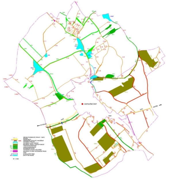
Figure 1. Example of Common Facilities Plan
In CFP there are often combinations of various types of measures to
complement each other. An example can be a field road with tree alley
and dike alongside (Fig. 2).
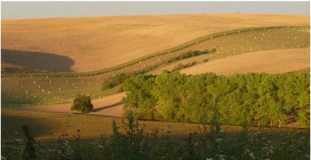
Figure 2. Erosion control belt with a planting
2.1.1 Measures for land accessibility
These measures are trying to solve the principles of the proposed
concept of the transport system and in the same time it includes
relations with the transport system network with the higher order. The
proposed transport system and its technical parameters must be in
accordance with the valid technical standards and regulations. This
transport system also has to fulfill the requirements for the movement
of the agricultural vehicles, enable the rational agriculture and other
use out of agricultural transport. Measures which provide land
accessibility include field or forest roads (Fig. 3), small bridges,
fords, railroad crossings etc.
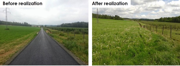
Figure 3. Example of measures for land accessibility
2.1.2 Ecological measures
Proposals of these measures have to document the process for
maintaining and improving the ecological stability of land after the
Land Consolidation Process. It also has to document the relations with
the areas out of bounds of the land consolidations and functional
relations with the transport, erosion control and water management parts
of the CFP.
To this category belong measures like local system of ecological
stability (biocenters, biocorridors), interaction elements, small water
pools, wetlands (Fig.4) etc.
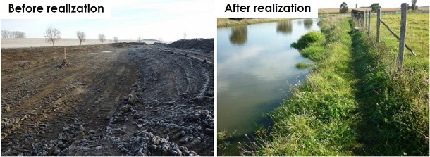
Figure 4. Example of ecological measure
2.1.3 Soil erosion control measures
To prevent soil erosion CFP often designes a complex of
organizational, agronomic and technical measures which complement each
other to reach the highest efficiency. These measures are aimed at
protecting watercourses, water pools and urban areas against the
negative effects of soil erosion, retarding surface runoff and
supporting water retention in the landscape, all with taking under
consideration requirements and abilities of the agriculture. The
enforceability of the measures, especially the “soft” ones
(organizational and agrotechnical), largely depends on the willingness
(or its lack) of agricultural subjects to implement these measures.
Therefore is essential to consult the planned measures with these
subjects.
Soil erosion control measures are divided into three groups:
- Organizational measures – grassing, foresting, shape and size of
the parcels, rotation of crops on the soil, change of land use (Fig.
5) etc.
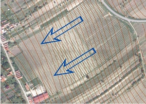
Figure 5. Change of land use (arable / vineyard with anti-erosion
function)
-
Agrotechnical measures – growing measures, grassing between
fields, seeding into protective crop (Fig. 6), leaving crop residues
etc.
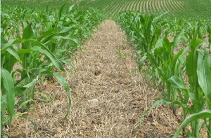
Figure 6. Seeding into protective crop
-
Technical measures – sedimentation reservoirs, ditches,
stabilization of the paths of runoff (Fig. 7), infiltration zones,
terraces, windbreaks etc.
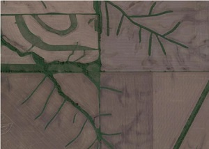
Figure 7. Stabilization of the paths of runoff
2.1.4 Water management measures
These measures deal with the water management with particular
attention to the relations in the watershed (which means also outside
the border of the land consolidation). The principles of these measures
are based on legal obligations consisted of improving water conditions,
drainage of surface water, flood protection, water resources protection,
surface and groundwater protection, measures for water works and the
elimination of the drought.
These measures are projected primarily to eliminate negative
hydrological conditions (floods, droughts) and they include reservoirs,
revitalizations of water streams, ponds, dams, stream adjustments etc.
2.2 Master Plan of Landscape Water Management of the Czech Republic
Master Plan of Landscape Water Management of the Czech Republic is a
project which is focused on conceptual modification of landscape with
respect to impacts associated with climate change. The project tries to
find new legislative, economical and technical solutions which can be
enforced by the process of Land Consolidations (CFP). The main
institutions involved under the rule of State Land Office are Czech
Agrarian Chamber, universities (Mendel University in Brno, Brno
University of Technology), Research Institute for Soil and Water
Conservation, T. G. Masaryk Water Research Institute and Global Change
Research Institute. This project from the agricultural practice aims to
define most vulnerable areas of the Czech Republic and develop
adaptation measures to mitigate negative effects, especially floods and
droughts. Proposed measures need to be acceptable by farmers. The
project responds to the priorities of the Government in the food
self-sufficiency, increasing flood protection, and increasing protection
of soil and landscape.
2.2.1 Description of the solution
First step of the solution was to describe the current situation
(studies, legislation, foreign experience, etc.) and evaluation of
available data sources.
The second step towards the implementation of the proposed framework
is the identification regions with the highest hazards so that the next
steps of risk assessment (vulnerability and exposure assessments) and
policy application can be targeted to these regions.
The potential indicators that could be used to for the assessment of
hazards are numerous. Because the focus of this study was on assessing
combined hazards for agricultural land, we focused on the indicators
that in our view can best be used to quantify these hazards.
Towards the assessment of the combined hazard (Fig. 8) for the
agricultural lands analyzed, we identified the following hazards as
being the most critical ones:
- Agricultural drought during the growing season
- Pre-existing poor soil conditions decreasing the ability of the
soil to hold water (quicklyt drying soils)
- Increased susceptibility to water erosion, including the
occurrence of concentrated runoff pathways
- Pre-existent infrastructure and/or settlements in the path of
the concentrated runoff pathways
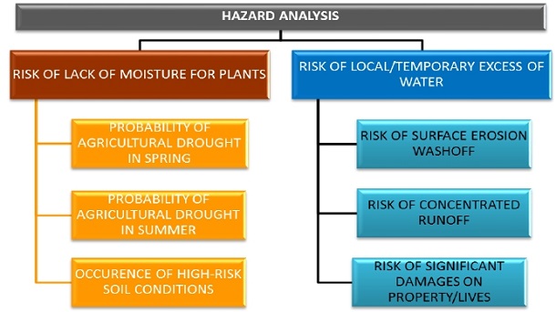
Figure 8. Overview of the individual hazard indicators with arrows
showing their interactions
2.2.2 Individual hazard indicators
Agricultural drought during the growing season
As the indicator of drought hazard, we selected the median number of
days per season (based on 1991-2014 data) with a saturation of the
surface soil layer below 30 % of the relative soil water content (i.e.,
the percentage up to which water fills the soil pores between the
so-called wilting point and field capacity) in the topsoil. In general,
this value could be considered as the level below which the
physiological processes of the plant begin to be significantly limited
by a lack of water (e.g., Larcher 2003). The calculations were performed
in 500 m grid covering the whole Czech Republic (Trnka et al., 2015b).
Based on the drought-yield relationship, we divided the growing season
into two parts: April-June and July-September. The former, mostly
spring- and winter-sown cereals (usually harvested in July) are known to
be affected the most (e.g., Hlavinka et al., 2009), while the latter
season represents the time period in which latter-maturing crops (e.g.,
maize, potatoes or sugar beets) can be negatively affected.
Quickly drying soils
In Czech Republic, this issue is of concern in the northwestern and
southeastern parts of the country. The expansion of fast drying soils is
driven by erosion, and many areas with very fertile soils less than 100
years ago (e.g., chernozems) are presently fast drying soils consisting
of an underlying loess or sand from the original bottom of the sea. The
process is accelerated by ongoing climate change connected with the
increasingly frequent occurrence of long periods of drought and also by
unsuitable tillage practices with a low re-supply rate of organic matter
to the soil. Determining the occurrence of fast drying soils was
performed through the evaluation of a high resolution (5x5 m grid) map
of the soil conditions based on the information obtained from the soil
database that is maintained and permanently updated by the Research
Institute for Soil and Water Conservation.
Sheet, interrill and rill soil erosion
The first indicator of an erosion hazard for agricultural land
focuses predominantly on so-called sheet erosion (i.e., the transport of
loosened soil particles by overland flow). In this study was used an
approach based on the universal soil loss equation USLE (Wischmeier &
Smith 1978). The topography factors were estimated according to the
modified equation of Desmet & Govers (Desmet & Govers 1996) using a 5x5
m grid digital elevation model. The efficiency factor of erosive
rainfall was set to R = 40 MJ.ha-1.cm.h-1 (Janeček et al. 2012), and the
C factor was based on the actual crop proportions at the same resolution
as the slope and length estimates. After estimating annual soil loss,
those 5x5 m grids showing the annual potential loss higher than 4 tons
per ha (i.e. nationally enforced limit) were marked as those with a
significantly higher than permissible erosion rate.
Rill and ephemeral gully erosion
In addition to the classic erosion furrows on the surface slopes of
arable land, there are also so-called “rills” and "ephemeral gullies'
present, which differ from the classic erosion furrows because of their
cross-sectional area (larger than 1 square foot) (Morgan, 2005).
For the analysis of ephemeral gully erosion hazards, the method of
plotting potential paths of runoff concentration at the spatial
resolution of 5 m was used. This method is based on the modeling of flow
accumulation from drainage areas, the interpretation of the nature of
the terrain and the visual interpretation of aerial photos of the
affected land blocks. Contributing areas were used to automatically
generate the direction and accumulation of runoff over a digital terrain
model with manual correction using raster topographic maps and aerial
orthophotos (Dumbrovský et al. 2011).
Localized floods originating from agricultural land
Drbal & Dumbrovský (2009) reported that even a contributing area of 5
ha is sufficient to generate a flow that can cause severe damage to
property. The causal factors critical for the formation of a
concentrated runoff were determined based on the number of recent flood
events from torrential rainfall, and parameters were set to estimate
so-called “critical points”. Critical point (CP) was defined as the
point where the trajectory of the concentrated runoff penetrates into
the municipality. CPs were thus determined based on the intersection of
a municipality (urban) boundary with concentric lines of a track
drainage area with the contributing to a region ≥ 0.3 km2. As the area
affected by torrential rainfall tends to be limited, the contributing
area was also limited to10 km2. In this analysis we assumed that
torrential rain could occur at any location in the Czech Republic.
2.2.3 Multiple hazard analysis
The original quantification of the indicators was based on different
resolutions, with data on drought occurrence being available as a 500 x
500 m grid and the remaining indicators being calculated at 5 m
resolution due to the importance of the local terrain conditions. As the
study aimed at identifying the areas with the highest hazard level for
policy making purposes, the indicators were aggregated at the level of
the cadaster unit, which is the smallest administrative unit in the
Czech administrative division system. For each cadaster unit, the value
of each indicator was calculated. All indicators were normalized using a
z-score approach. It is one of the most commonly used normalization
procedures in which all indicators are converted into a common scale
with an average of zero and the standard deviation of one.
Value of Z-score was calculated as:
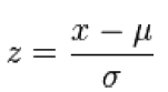
where:
x - parameter value in the cadastral; μ - average value for all
cadastral; σ – standard deviation for all cadastral
Hazard of solved area was classified according to the value of Z-scores
as show Table 1.
Table 1: Z-score table used to interpret the standardized values of
the indicators

2.2.4 Results of Multiple hazard analysis
Spatial distribution of multiple hazard analysis is shown in Fig. 9.
The percentage of territory at where the hazard level is highly above
average or worse is 8% (Fig. 9a). Within the multi-criteria analysis,
was simultaneously examined how a large part of the territory of Czech
Republic meets at least one of the criteria for an extreme degree of
risk (Fig. 9b). This combined approach provides a good overview of the
areas where the hazard level is significantly higher than the rest of
the territory. The last step of this analysis was to define the
territory that may be considered to be at a particularly high risk. As
such, was considered a territory where the average value of the z-scores
was higher than 1.5 and/or where at least two criteria had z-scores
above 2.0 to be at a high risk. These criteria are met by 4.5% of the
territory of Czech Republic. As Fig. 9c shows, two areas can be
pinpointed as the most at risk. These most vulnerable regions constitute
areas where attention and resources should be given the highest
priority.
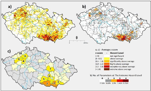
Figure 9. The result of the multiple-hazard analysis at the cadastre
(a-b) and district (c) level: a) mean z-score of all six individual
hazards, b) number of individual hazards per cadastre unit in the worst
category, and c) the districts with the highest combined hazard level
within the country. The top 10 regions according to hazard level are
numbered.
3. CONCLUSION
The mapping of multiple hazards for agricultural land is intended as
an important step in the assessment of the vulnerability of the
agricultural sector to the occurrence of drought and extreme
precipitation events under the present conditions and under the
predicted future climate conditions in Czech Republic. The map presented
here synthesizes a variety of data and serves as an indicator of areas
deserving more detailed attention. Regions whith highest hazard level
are concentrated in the southeastern and northwestern lowland areas. As
typical areas with the highest hazard levels, we can identify regions
with below average precipitation and a high proportion of soils with a
degraded or naturally occurring low water-holding capacity, and those
with steeper than average slopes and terrain configurations in
relatively large catchment areas that have urbanized landscapes located
at their lower elevations.
The identification of the most vulnerable areas in the Czech Republic
through a multi-hazard analysis is an important source of information in
guiding the prioritization of the land consolidation process and its
spatial targeting for the State Land Office. In this way, the State Land
Office receives unique material that can be used to improve their
ability to mitigate the impacts of climate change. In addition, it will
be able to effectively participate in the establishment of a legislative
and economic framework that could possibly realize adaptation measures
acceptable to agricultural entities.
As the next step in the search of new measures (technical, economic
and legislative) and their efficient spatial targeting will be analyzed
in detail farms from areas with the highest hazard levels. It will also
made a detailed proposal of adaptation measures that will be acceptable
to farms under the current (climate, economical, legislative) and future
(climate) conditions. Experiences from the pilot farms will help
indicate the necessary adaptation measures for the future. An important
question is the political will and ability to enforce the necessary
adaptation measures at national and international level.
REFERENCES
Desmet PJJ, Govers G (1996) A GIS procedure for automatically
calculating the USLE LS factor on topographically complex landscape
units. J Soil Water Conserv 51: 427-433.
Drbal, K., Dumbrovský, M. et al. (2009): Metodický návod pro
identifikaci KB. Brno: Ministry of Environment of the Czech Republic,
Prague (http://www.povis.cz/html/download_smernice.htm)
Dumbrovský, M., Ekotoxa. 2011. Vymezení přispívajících ploch nad
závěrovými profily erozně ohrožených drah odtoku na orné půdě pro
potřeby Rámcové směrnice pro vodní politiku 2000/60/ES. 2011.
Hlavinka P, Trnka M, Semerádová D, Dubrovský M, Zalud Z, Mozný M
(2009) Effect of drought on yield variability of key crops in Czech
Republic. Agric For Meteorol 149:431–442.
Janeček M, Dostál T, Kozlovsky-Dufková J, Dumbrovský M, Hůla J,
Kadlec V, Kovář P, Krása T, Kubátová E,
Kobzová D, Kudrnáčová M, Novotný I, Podhrázská J, Pražan J,
Procházková E, Středová I, Toman F, Vopravil J, Vlasák J (2012) Erosion
Control in the Czech Republic - handbook. Czech University of Life
Sciences. Prague, p. 113.
Kappes MS, Keiler M, von Elverfeldt K, Glade T (2012) Challenges of
analyzing multi-hazard risk: a review. Nat Hazards 64:1925 –1958.
Larcher, W. (2003) Physiological Plant Ecology - 4th edition,
SpringerVerlag, Berlin, Heidelberg, New York.
Morgan RPC (2005) Soil Erosion and Conservation. Third Edition.
Oxford: Blackwell Publishing.
Trnka M, Hlavinka P, Semenov MA (2015a) Adaptation options for wheat
in Europe will be limited by increased adverse weather events under
climate change, J R Soc Interface 12: 20150721.
Trnka M, Semerádová D, Novotný I, Dumbrovský D, Drbal K, Pavlík F,
Vopravil J, Štìpánková P, Vizina A, Balek J,Hlavinka P, Bartošová L,
Žalud Z (2016). Assessing the combined hazards of drought, soil erosion
and local flooding on agricultural land: A Czech case study. doi:
10.3354/cr01421.
Vopravil J, Rožnovský J, Hladík J, Khel T, Batysta M, Litschman T,
Støeda T, Støadová H, Srbek J, Novotný I, Smolíková J, Novák P, Hejduk
T, Chuchma F, Kohout M, Kniezková T, Krmelová P (2012) Možnosti øešení
degradace pùdy a její ovlivnìní zmìnou klimatu na pøíkladu aridních
oblastí. MZe ÈR.
Wischmeier WH, Smith DD (1978) Predicting rainfall erosion losses:
guide to conservation planning. USDA, Agriculture Handbook 537. U.S.
Government Printing Office, Washington, DC.
BIOGRAPHICAL NOTES
Ing. Frantisek Pavlik, Ph.D. is a Head of department at State Land
Office of the Czech Republic and works in the field of land
consolidations, soil coservation, and geoinformatics. He studied at Brno
University of Technology where he obtained PhD Degree with his thesis
“Quantification of Natural Water Retention Capacity in Selected
Watersheds” (2014). After graduation he works as a researcher at Palacký
University Olomouc and T. G. Masaryk Water Research Institute. He
published in Acta Universitatis Agriculturae et Silviculturae
Mendelianae Brunensis, in Fresenius Enviromental Bulletin and he also
contributed as an author to a books about degradation and regeneration
of soils and landscape. He also works on research projects during his
studies and further career in field of water retention, erosion, land
consolidation and soil degradation.
CONTACTS
Ing. František Pavlík, Ph.D.
State Land Office
Husinecká 1024/11a
Prague
CZECH REPUBLIC
Tel. +420 729 922 528
Email: f.pavlik@spucr.cz
Web site: www.spucr.cz